
Maryland and Virginia Snow Potential Remains Uncertain as NWS Monitors Sunday System With Possible I-95 Corridor Impacts
VIRGINIA — Forecasters are closely watching a potential winter weather system that could bring snow to parts of Maryland and Virginia from Sunday into Sunday night, though confidence remains low as uncertainty persists around the storm’s track and northwest reach.
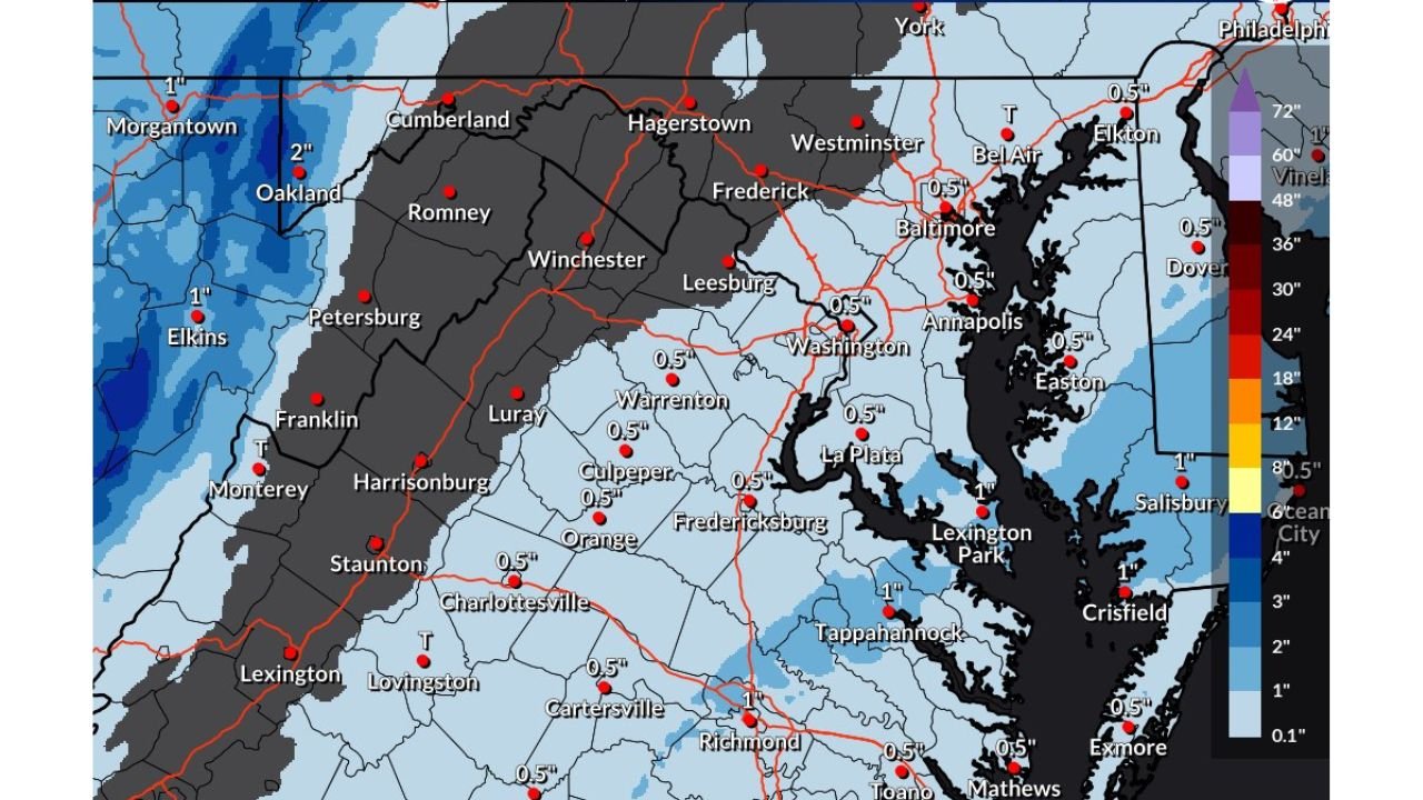
According to the latest National Weather Service (NWS) Baltimore/Washington forecast, the greatest chance for accumulating snow is currently focused on Southern Maryland and areas to the southeast, while much of central Maryland, northern Virginia, and the I-95 corridor sit near the edge of the projected snow shield. Small changes in the storm’s path could significantly alter impacts, especially for heavily traveled metro areas.
What the Current NWS Forecast Indicates
The official snowfall outlook valid through 7 PM Sunday shows generally light snow totals across portions of the region, with many locations currently forecast around 0.5 inch. However, this does not mean the forecast is locked in.
Based on the current data:
- Southern Maryland and coastal areas have the highest probability of accumulating snow
- Central Maryland and Northern Virginia, including areas near Washington, D.C., remain on the northern fringe of the system
- Western Maryland and the Appalachians are expected to see little to no impact
- Snow amounts drop off sharply just northwest of the storm’s core
This sharp gradient highlights why forecast confidence remains limited at this time.
Why Confidence Is Still Low
Meteorologists emphasize that the storm track is the main wildcard. Even a slight westward shift could bring accumulating snow closer to the I-95 corridor, potentially impacting:
- Washington, D.C.
- Baltimore
- Annapolis
- Nearby suburbs in Maryland and Virginia
If the storm remains farther east, snowfall would likely stay confined to Southern Maryland and coastal communities, with minimal inland effects.
Timing and Potential Impacts
If snow does develop, it would most likely occur Sunday afternoon through Sunday night. While totals currently appear modest, timing could still cause issues, especially if snow falls during the evening hours when temperatures drop and roads cool quickly.
Possible impacts include:
- Slick road conditions
- Reduced visibility at times
- Localized travel delays
- Rapid changes in conditions depending on location
What to Watch Over the Next Few Days
Forecasters will be monitoring:
- New model trends
- Any westward or eastward shifts in the storm track
- Temperature profiles, which will determine rain versus snow
- Expansion or contraction of the snow shield
Residents across Maryland and Virginia are encouraged to stay informed, as minor forecast adjustments could lead to noticeable changes in snowfall expectations, especially in densely populated areas.
Bottom Line
A potential snow system remains in play for Maryland and Virginia this Sunday, but uncertainty remains high. For now, Southern Maryland holds the greatest chance for snow, while the I-95 corridor remains on watch should the storm trend west.
Do you think this system will shift west and bring snow to your area, or stay confined farther south and east? Share your thoughts and stay updated with the latest regional weather coverage by following Waldron News.