
Maryland and Virginia Weather Shock: 31-Degree Temperature Gap Between Baltimore and Harrisonburg Highlights Dramatic Cold Air Damming
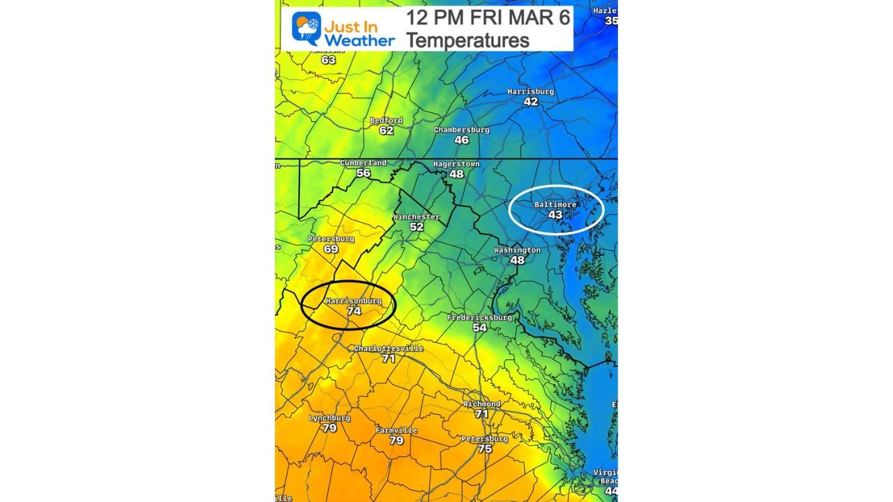
BALTIMORE, MARYLAND — A striking weather contrast unfolded across the Mid-Atlantic Friday afternoon as a powerful atmospheric setup known as cold air damming created a dramatic 31-degree temperature difference between Baltimore, Maryland and Harrisonburg, Virginia, despite the two cities being only about 130 miles apart.
Temperature observations around 12 PM on Friday, March 6 revealed a sharp boundary across the region. Baltimore remained stuck in chilly conditions near 43°F, while Harrisonburg, located west of the Blue Ridge Mountains, warmed to around 74°F under sunshine.
The unusual temperature gap illustrates how dramatically weather conditions can change over relatively short distances when terrain and atmospheric patterns interact.
A Short Drive Separates Two Completely Different Weather Patterns
Although Baltimore and Harrisonburg are separated by roughly 130 miles, the drive between the cities crosses the Appalachian and Blue Ridge mountain ranges, which play a major role in shaping regional weather patterns.
On Friday, those mountains helped trap colder air east of the range while warmer air surged northward across the Shenandoah Valley and central Virginia.
The result was a stark contrast in conditions:
- Baltimore, Maryland: around 43°F, cloudy and much cooler
- Washington, D.C.: near 48°F
- Hagerstown, Maryland: about 48°F
- Winchester, Virginia: around 52°F
- Harrisonburg, Virginia: approximately 74°F
- Charlottesville, Virginia: near 71°F
- Richmond, Virginia: roughly 71°F
This sharp temperature divide developed over just a few counties.
Cold Air Damming Locks Cooler Air Along the East Coast
The dramatic temperature difference was caused by cold air damming, a weather pattern where cool, dense air becomes trapped along the eastern side of mountain ranges.
In this setup, cooler air flows southward along the eastern slopes of the Appalachians and becomes difficult to displace. At the same time, warmer air can move freely across areas west of the mountains.
The cold air essentially becomes “dammed” against the mountains, leading to much cooler temperatures across cities closer to the Atlantic coast while inland valleys warm significantly.
This phenomenon frequently affects states across the Mid-Atlantic and Southeast, including:
- Maryland
- Virginia
- North Carolina
- Pennsylvania
During strong cold air damming events, temperatures can vary dramatically over short distances.
Mid-Atlantic Region Experiences One of the Largest Temperature Contrasts
Friday’s setup produced one of the most noticeable contrasts across the region, with temperature colors on weather maps showing a clear divide.
Cooler shades dominated areas near the Chesapeake Bay and the Interstate-95 corridor, while warmer yellows and oranges covered central and southern Virginia.
Communities located near the dividing line between these air masses often experience the fastest changes, with temperatures rising quickly once the colder air begins to break down.
Weather Patterns Like This Are Common in Early Spring
Early March is one of the most active times of year for cold air damming events because winter and spring weather patterns often collide.
Warm air from the south frequently attempts to move northward during this time of year, while lingering cold air masses remain entrenched near the East Coast.
When the mountains block the movement of air masses, dramatic temperature gradients like Friday’s event can develop quickly.
These patterns can also influence cloud cover, precipitation, and storm development across the region.
Conditions Expected to Shift as Weather Patterns Change
Cold air damming events usually weaken as warmer air gradually mixes into the cooler air mass or as stronger winds disrupt the trapped air near the surface.
Once that occurs, temperatures across cities like Baltimore and Washington may climb rapidly, bringing conditions closer to what areas west of the mountains are experiencing.
Until then, residents across the Mid-Atlantic may continue seeing large temperature swings depending on location and elevation.
Stay with WaldronNews for continuing coverage of major weather patterns and developing forecasts across the United States.