
Maryland Braces for Light but Widespread Snow as Baltimore, Central Maryland, and the Eastern Shore See 1–3 Inches Before Arctic Cold Arrives
MARYLAND — A light but impactful snow event is unfolding across Maryland, with Baltimore, central Maryland, and parts of the Eastern Shore expected to pick up 1 to 3 inches of snow through Sunday, followed closely by a sharp blast of Arctic cold early next week. While this system is not expected to be a major winter storm, forecasters say it will be just enough to cause travel issues, slick roads, and minor disruptions, especially during overnight and early morning hours.
Latest forecast updates show a slight upward trend in snowfall potential, prompting officials to urge residents to remain cautious despite relatively modest totals.
Snow Totals: Where Accumulations Will Be Highest
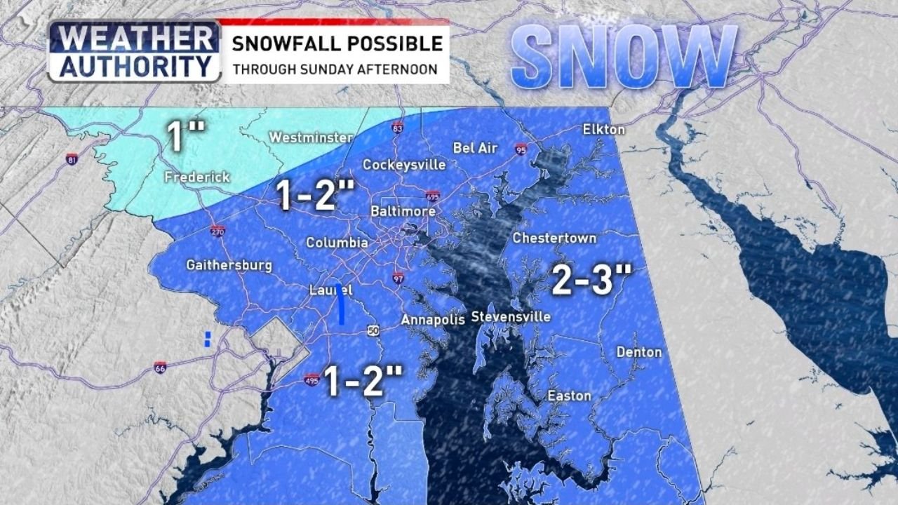
Based on the official forecast and snowfall maps, most of Maryland will see measurable snow, with totals varying by location.
- Baltimore Metro Area:
- 1–2 inches expected for most neighborhoods
- Isolated pockets could see up to 3 inches, especially in heavier bands
- Central Maryland (Columbia, Laurel, Gaithersburg):
- Generally 1–2 inches
- Eastern Shore (Chestertown, Stevensville, Easton, Denton):
- 2–3 inches, the highest totals in the state
- Northern Maryland (Frederick, Westminster):
- Around 1 inch, tapering off farther north and west
Snowfall will not be uniform, and localized heavier bursts could briefly reduce visibility and quickly coat untreated roads.
Two Rounds of Snow Expected
Forecasters indicate this system will arrive in two separate waves:
- First round: Ongoing snow tapering off around mid-day today
- Second round: Redeveloping early Sunday morning before daybreak, lasting through much of the morning
The second round may be more impactful due to colder surface temperatures, allowing snow to accumulate more efficiently on roadways.
Not a Major Storm, But Enough to Matter
Meteorologists stress that this is not a blockbuster winter storm, but it carries enough impact to be noticed.
- Light plowing or shoveling may be needed in some areas
- Roads could become slick, especially bridges and untreated surfaces
- Children may find conditions suitable for sledding in spots, depending on totals
Because snow amounts are modest, impacts will largely depend on timing and temperature, particularly during the Sunday morning commute.
Arctic Cold Follows the Snow
Perhaps the bigger concern comes after the snow ends. Forecasts show a very cold day arriving Tuesday, with daytime highs struggling to reach the upper 20s and morning lows dropping into the teens.
This surge of cold air could:
- Cause refreezing of melted snow and slush
- Increase the risk of school delays or closures
- Put stress on heating systems and exposed pipes
What to Watch Going Forward
Snow will gradually wind down by Sunday afternoon, but residents across Maryland should remain alert as dangerous cold air follows closely behind. Even light snow can lead to outsized impacts when temperatures plunge afterward.
Drivers are encouraged to slow down, allow extra travel time, and monitor local updates as conditions evolve. While this system may be relatively minor, it serves as another reminder that winter weather remains firmly in control across the Mid-Atlantic.