
Maryland Braces for Two Morning Snow Bursts as Baltimore Faces Slick Roads on New Year’s Eve and Arctic Cold on New Year’s Day
MARYLAND — A brief but impactful winter weather pattern is setting up across central and northern Maryland, with two early-morning snow bursts expected around the same time on New Year’s Eve and New Year’s Day, followed by a sharp plunge in temperatures as an arctic front sweeps through the region.
Forecast models show these events occurring before sunrise, creating a heightened risk for slick roads during the morning commute, particularly around Baltimore and nearby suburbs.
New Year’s Eve Morning: Quick Snow Burst Around Baltimore
On Wednesday morning (New Year’s Eve), guidance from multiple high-resolution weather models indicates a short-lived burst of snow developing near Baltimore around 5 a.m.
Key details from the forecast:
- Timing: Roughly 4 a.m. to 8 a.m.
- Snow amounts: A coating up to one-half inch
- Temperatures: In the 20s
- Primary impact: Roads becoming slick, especially untreated surfaces
While snowfall totals are modest, the timing is critical, as even a light accumulation can create hazardous conditions during early morning travel.
Areas Most Likely to See Snow Wednesday Morning
The snow burst may affect locations within about 50 miles of Baltimore, with the best chances focused on:
- Baltimore City and Baltimore County
- The western side of Frederick
- Washington, D.C. metro area
- Northern Maryland near York, Pennsylvania
- Chesapeake Bay region, including northeastern Maryland and the Delmarva Peninsula
Forecasters note there is still some margin of error in placement, meaning some communities may see little or no snow while others experience a quick burst.
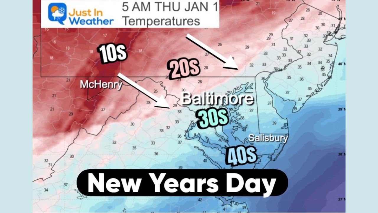
New Year’s Day: Arctic Front Brings Another Snow Squall Risk
On Thursday morning (New Year’s Day), attention turns to a fast-moving arctic front pushing through the Mid-Atlantic.
This front may trigger:
- A narrow snow squall line
- Another light coating of snow
- Sudden visibility drops
- Rapidly changing road conditions
Although snowfall amounts again appear limited, snow squalls can create dangerous travel conditions in minutes, especially if they coincide with strong winds.
Powerful Winds and Temperatures Tumbling
Behind the arctic front, conditions will turn sharply colder:
- Wind gusts: Up to 50 mph
- Temperatures: Falling into the teens and lower 20s
- Wind chills: Potentially in the single digits
The combination of wind and cold will make conditions feel much harsher than recent days and could cause blowing snow where accumulation occurs.
What This Means for Travelers
Even though this is not a major snowstorm, the setup is concerning due to:
- Poor timing during morning travel
- Quick-hitting snow bursts
- Rapid temperature drops
- Strong winds following the snow
Drivers should be prepared for sudden slick spots, especially on bridges, overpasses, and secondary roads.
Looking Ahead
Forecasters will be closely monitoring overnight model trends to refine snowfall placement and intensity. Small shifts could change which neighborhoods see snow and which stay dry.
Stay with WaldronNews.com for continued updates on Maryland winter weather, including Baltimore snow chances, road conditions, and arctic cold impacts as the New Year begins.