
Maryland Braces for Weekend Snowstorm Showdown as GFS Signals “Monster” Setup While Euro Paints Lighter Event for Baltimore
MARYLAND — A growing divide between two major global weather models is setting the stage for a high-stakes forecast battle ahead of the Sunday–Monday winter storm, with dramatically different snowfall implications for Baltimore and surrounding areas.
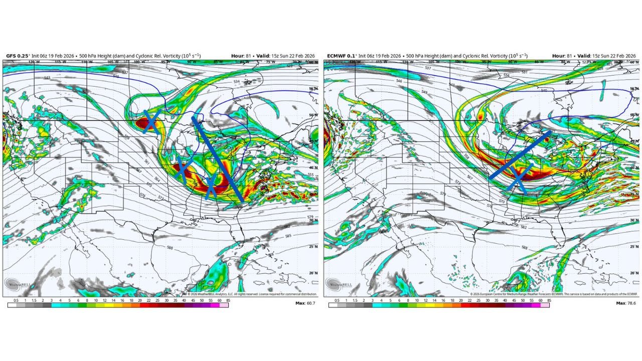
At the heart of the disagreement is how the upper-level trough evolves over the central and eastern United States — and whether it takes on a powerful negative tilt capable of producing a major Mid-Atlantic snowstorm.
GFS: Negative Tilt and Phasing Could Deliver Heavy Snow to Maryland
The American GFS model depicts a dynamic setup at 500mb, showing a negatively tilted upper trough digging into the Tennessee Valley and Mid-Atlantic. This orientation allows stronger phasing of upper-level energy and enhanced cyclonic vorticity.
Under this scenario:
- The trough sharpens as it approaches the East Coast.
- Stronger lift develops over Virginia and Maryland.
- Moisture wraps northward into the I-95 corridor.
- Baltimore could see a high-impact snowfall event.
The GFS solution suggests a more amplified system with stronger upper-level support — a configuration that often leads to heavier precipitation rates and more organized coastal development.
If this version verifies, central Maryland could experience a more robust snow event, particularly Sunday into early Monday.
ECMWF: Flatter, Open Wave Means Less Snow for Baltimore
The European ECMWF model presents a notably different picture.
Instead of a negatively tilted trough, the Euro shows a flatter, open wave that leans positive. This means:
- Less phasing of upper-level energy.
- A more progressive system.
- Reduced amplification along the East Coast.
- Lower snowfall totals overall.
In this solution, Baltimore still sees some snow, but the event would be far less intense than the GFS projection.
The flatter orientation prevents stronger cyclogenesis near the coast, limiting both precipitation intensity and duration.
Why the Upper-Level Tilt Matters
The difference between a negative tilt and a positive tilt is critical in winter storm forecasting:
- Negative tilt: Encourages stronger upward motion and rapid storm strengthening.
- Positive or flat tilt: Keeps systems weaker and more progressive.
The GFS highlights stronger vorticity maxima digging into the Mid-South and Mid-Atlantic, while the Euro keeps energy more stretched and less consolidated.
That structural difference alone explains the significant snowfall gap between the two models.
What This Means for Baltimore and Central Maryland
At this stage:
- Snow appears likely Sunday into Monday.
- Confidence in exact totals remains low.
- A major “monster” event is possible — but far from guaranteed.
Current lean based on model consensus trends favors the Euro’s less aggressive solution, meaning accumulating snow but not necessarily a historic storm.
However, the setup still contains enough volatility that shifts in upper-level energy could quickly trend the forecast upward.
Timing and Next Updates
Both models show the system impacting the Mid-Atlantic during the Sunday–Monday timeframe, with peak impacts likely Sunday afternoon into early Monday morning.
Additional model runs today will refine:
- Upper-level trough orientation
- Degree of phasing
- Coastal development strength
- Snowfall totals across Maryland
Bottom Line
Maryland remains in the crosshairs of a developing winter system, but whether Baltimore sees a moderate snowfall or a high-impact “monster” event depends entirely on upper-level dynamics still in flux.
The GFS paints a high-end snow potential for central Maryland, while the Euro keeps the storm more subdued.
Forecast confidence should increase as new data arrives later today.
Stay with WaldronNews.com for updated snowfall projections and detailed local impacts as this weekend’s storm track becomes clearer.