
Maryland, Pennsylvania, New Jersey, Delaware, and Virginia Placed Under Winter Weather Alerts as Weekend Snow Event Targets Mid-Atlantic Region
MARYLAND — The first round of winter weather alerts has been issued across parts of the Mid-Atlantic as a quick-moving snow system is expected to impact the region this weekend, bringing accumulating snowfall, overnight travel concerns, and the potential for additional advisories or warnings as the event draws closer.
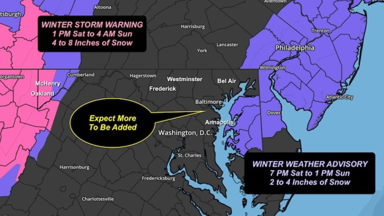
Current alerts cover portions of Maryland, Pennsylvania, New Jersey, Delaware, and Virginia, with forecasters indicating that more alerts are likely, especially across central Maryland, as forecast confidence increases and timing differences between forecast offices are resolved.
Winter Weather Alerts Issued Ahead of Weekend Snow Event
As of the latest updates, Winter Weather Advisories and Winter Storm Warnings are already in place for parts of the region.
Areas farther west and northwest, including portions of western Maryland and southern Pennsylvania, are under Winter Storm Warnings, where 4 to 8 inches of snow is expected from Saturday afternoon through early Sunday morning.
Farther east, including parts of New Jersey, Delaware, and coastal Maryland, Winter Weather Advisories are in effect, with expected snowfall totals generally ranging from 2 to 4 inches, tapering to lighter amounts closer to the coast.
Some areas currently not under alerts are flagged as “expect more to be added,” signaling a likely expansion of advisories as the event approaches.
Snowfall Totals: Most Areas 1 to 3 Inches, Higher Amounts Possible West
Updated snowfall projections indicate:
- Most of the region: 1 to 3 inches
- Central Maryland into southern Pennsylvania: 2 to 4 inches
- Far western Maryland and nearby higher terrain: 4 to 8 inches
- Coastal areas: A coating to 1 inch possible
“Overlapping snow bands” are expected, which could allow localized higher totals, especially in areas that experience persistent snowfall for several hours.
Timing: Main Snow Event Overnight Saturday Into Sunday Morning
The primary snow event is expected to unfold overnight Saturday into early Sunday morning, which increases the risk for hazardous travel conditions, especially on untreated roads.
Heaviest snowfall is most likely to occur a few hours before and after sunrise Sunday, a period that could impact early morning travel, emergency services, and road crews.
Jet Stream Setup Driving Snow Burst
One of the key drivers behind this snow event is a powerful upper-level jet streak, with winds estimated between 115 and 130 mph several miles above the surface.
This jet stream configuration enhances lift in the atmosphere, helping to rapidly intensify snowfall rates for short periods.
“Jet streak energy is the main reason for this burst of snow,” highlighting why snowfall may be brief but intense in some locations.
Forecast Confidence Improving, But Some Uncertainty Remains
While confidence is increasing, forecasters note that small shifts in storm track or timing could still influence final snowfall totals and alert boundaries.
Differences between computer models and official forecasts are narrowing, but final adjustments are still expected, particularly across central Maryland and nearby regions.
Residents are encouraged to monitor updates closely as alert areas and snowfall projections may change.
What Residents Should Prepare For
Based on current guidance:
- Snow-covered roads overnight and early Sunday
- Reduced visibility during heavier snow bursts
- Localized higher snowfall totals under persistent bands
- Potential for additional winter weather alerts
Drivers traveling late Saturday night or early Sunday morning should plan for slower travel and changing road conditions.
The Mid-Atlantic is facing its first organized winter weather event of the season, with snow expected to impact Maryland, Pennsylvania, New Jersey, Delaware, and Virginia this weekend.
While snowfall amounts are generally modest for most areas, timing, overnight accumulation, and localized heavier bands could still create travel issues.
Stay alert for forecast updates and continue following local coverage for the latest developments at WaldronNews.com.