
Maryland, Pennsylvania, New York, and New England Brace for Super Bowl Weekend Arctic Blast With Snow, Dangerous Wind Chills, and Icing Risks
UNITED STATES — A powerful Arctic outbreak is setting the stage for a dangerous Super Bowl weekend across the Northeast, with multiple states facing light to moderate snow, intense winds, and life-threatening cold from Friday through early Sunday. Forecast models consistently show a clipper system, followed by an Arctic front, ushering in some of the coldest conditions of the winter season across the region.
Snow Threat Focused on Maryland, Pennsylvania, and New England
Forecast guidance indicates light but impactful snowfall beginning Friday and continuing into Saturday, particularly across western Maryland, central and western Pennsylvania, and parts of New England.
- Western Maryland — including areas near Oakland and Garrett County — could see 4 inches or more of snow between Friday morning and early Saturday.
- Central Maryland, including the Baltimore metro area, is expected to see much lighter accumulations, generally a dusting to a few tenths of an inch, mainly Friday evening.
- Pennsylvania and interior New England may experience periodic snow showers, with locally higher amounts where bands persist.
Even minor accumulations may lead to slick roads, especially during the Friday evening commute, as surface temperatures remain below freezing.
Ocean-Effect Snow Possible in Coastal New England
High-resolution model guidance, including the Hi-Res NAM, shows a north-northeast (NNE) flow off the Atlantic developing Friday. This setup could generate ocean-effect snow showers across coastal Massachusetts, Rhode Island, and parts of eastern New England as frigid air passes over relatively warmer ocean waters.
Snow totals from these bands are expected to be spotty, but brief heavier bursts could reduce visibility and create rapidly changing road conditions.
Arctic Front Brings Extreme Cold and Violent Wind Chills
The most dangerous part of this forecast arrives Saturday night into Sunday morning, when the Arctic air mass fully settles across the Northeast.
Forecast wind chill maps show:
- Wind chills of -15°F to -30°F across Pennsylvania, New York, and New England
- Sub-zero wind chills extending southward into Maryland
- Actual temperatures running 20–30 degrees below average
Sunday is shaping up to be a strong contender for the coldest day of the season across much of the region.
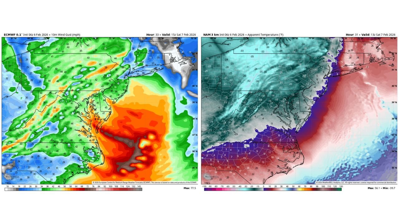
Strong Winds and Icing Along the Chesapeake Bay
Behind the Arctic front, northwest winds may gust between 40 and 55 mph, especially Saturday. These winds will:
- Turn any existing snow into blowing snow
- Create areas of reduced visibility
- Increase the risk of power disruptions
Along the Chesapeake Bay, forecasters are also monitoring the risk of freezing spray, where strong winds and sub-freezing air temperatures cause ice buildup on exposed surfaces and marine structures.
Cold Is Brief, But Impactful
While the cold will be short-lived, its intensity makes this a high-impact winter event, especially for travelers, outdoor activities, and Super Bowl plans.
The good news: temperatures are expected to moderate next week, bringing an end to this extreme stretch.
What to Watch Closely
- Friday evening travel impacts from light snow
- Rapid temperature drops behind the Arctic front
- Dangerous wind chills Saturday night and Sunday morning
- Blowing snow and freezing spray near coastal and bay areas
Stay weather-aware and take cold safety seriously this weekend.
Have you seen similar cold in your area this winter, or is this the worst so far? Share your experience and stay updated with the latest forecasts at WaldronNews.com.