
Maryland Sees Rare Thundersnow in Baltimore as Heavy Snow, Fog, and Lightning Hit BWI Area Early Morning
BALTIMORE, MARYLAND — A rare and intense winter weather event unfolded early Sunday morning as thundersnow was officially confirmed in Baltimore, with observations recorded near Baltimore/Washington International Thurgood Marshall Airport (BWI) around 4:25 a.m. The event combined thunder, lightning, heavy snowfall, and dense fog, creating dangerous travel and visibility conditions across parts of central Maryland.
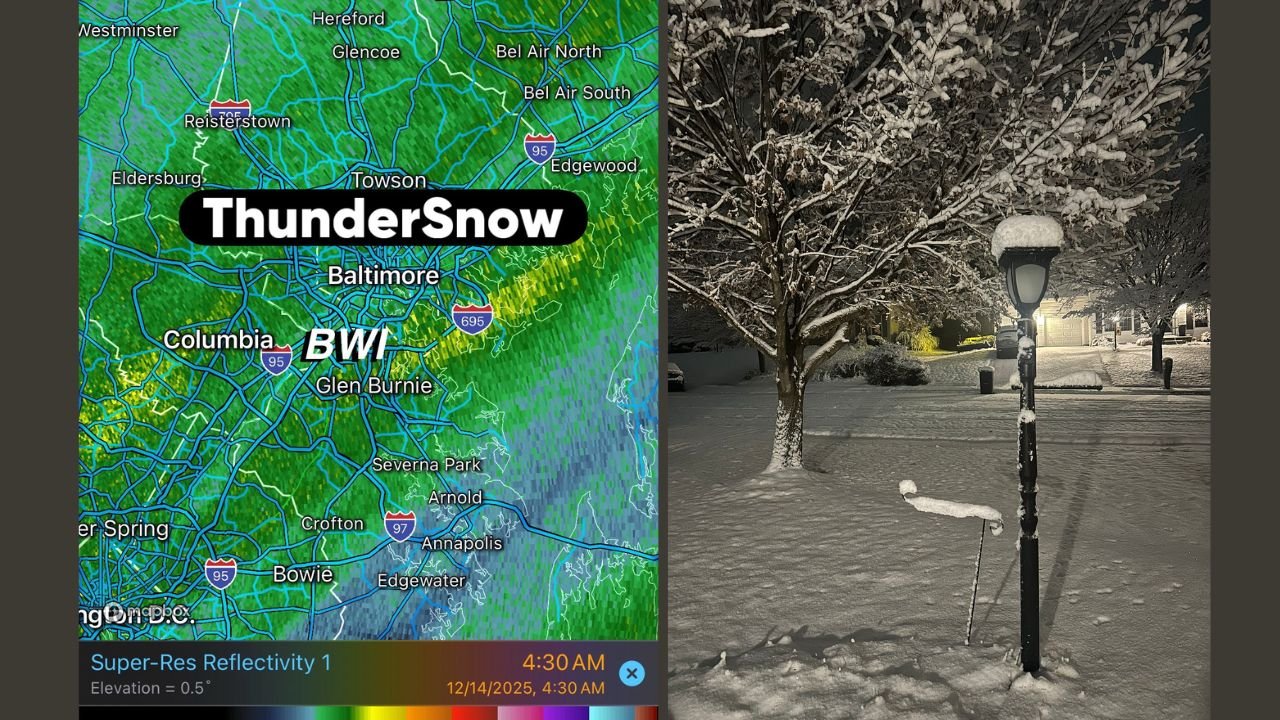
Radar imagery and surface observations show the storm developed rapidly, producing bursts of heavy snow accompanied by thunder — a phenomenon seldom seen in the Mid-Atlantic.
Thundersnow Confirmed Near BWI During Early-Morning Hours
Meteorological data from BWI confirms that thundersnow was observed at approximately 4:26 a.m., with weather conditions listed as:
“Thunder, heavy snow, and fog”
At the time of the observation, temperatures hovered around 32 degrees, humidity reached 100 percent, and visibility dropped to as low as 0.25 miles, according to station data. These conditions are consistent with intense snowfall rates capable of reducing visibility in a matter of minutes.
Radar imagery shows strong snow bands passing directly over Baltimore, Glen Burnie, and surrounding communities, with embedded lightning signatures confirming the thundersnow event.
Heavy Snow Totals Reported Near Maryland–Pennsylvania Line
In addition to the confirmed thundersnow, reports indicate approximately 5 inches of snow had already accumulated in areas near the Maryland–Pennsylvania state line by early morning.
The combination of heavy snowfall rates and fog significantly reduced visibility across roadways, especially in suburban and elevated areas.
“We have about 5 inches here around the MD/PA line,” one early report noted as snowfall continued.
Why Thundersnow Is Rare — And Dangerous
Thundersnow occurs when strong upward motion in the atmosphere allows snow-producing clouds to generate enough electrical charge for lightning. Unlike typical snowstorms, thundersnow often produces extremely heavy snowfall in short bursts, sometimes exceeding 1 to 2 inches per hour.
Because it develops quickly, it can catch drivers off guard.
“If you encounter thundersnow, conditions can deteriorate almost instantly,” meteorologists warn.
Visibility Drops and Travel Impacts Across Central Maryland
Surface observations show visibility fluctuating between 0.25 and 1 mile during the heaviest snowfall, with fog compounding the hazard. Roads that appeared merely wet earlier in the night rapidly became snow-covered and slick.
Officials urge motorists to delay non-essential travel, reduce speed, and remain alert for rapidly changing road conditions.
Residents Share Early-Morning Snowfall Scenes
Photos shared from neighborhoods across the Baltimore area show snow-covered trees, sidewalks, and residential streets, highlighting how quickly the storm intensified overnight. One widely shared image showed a family dog experiencing its first snowfall, underscoring the depth and freshness of accumulation during the early morning hours.
“First call for snowfall,” one post read, as residents were asked to share locations and photos from across Maryland.
What Comes Next
While the most intense thundersnow activity moved through before sunrise, snow showers and reduced visibility may linger into the morning hours. With temperatures near freezing, untreated roads and sidewalks remain hazardous.
Residents are advised to:
- Allow extra time for travel
- Use caution on bridges and secondary roads
- Monitor local updates for any additional advisories
WaldronNews.com will continue to track winter weather developments across Maryland, including snowfall totals, travel impacts, and any additional alerts issued throughout the day.