
Maryland, Virginia, and Washington D.C. Snow Forecast Updated as Northeast Maryland Added to New 2–3 Inch Zone
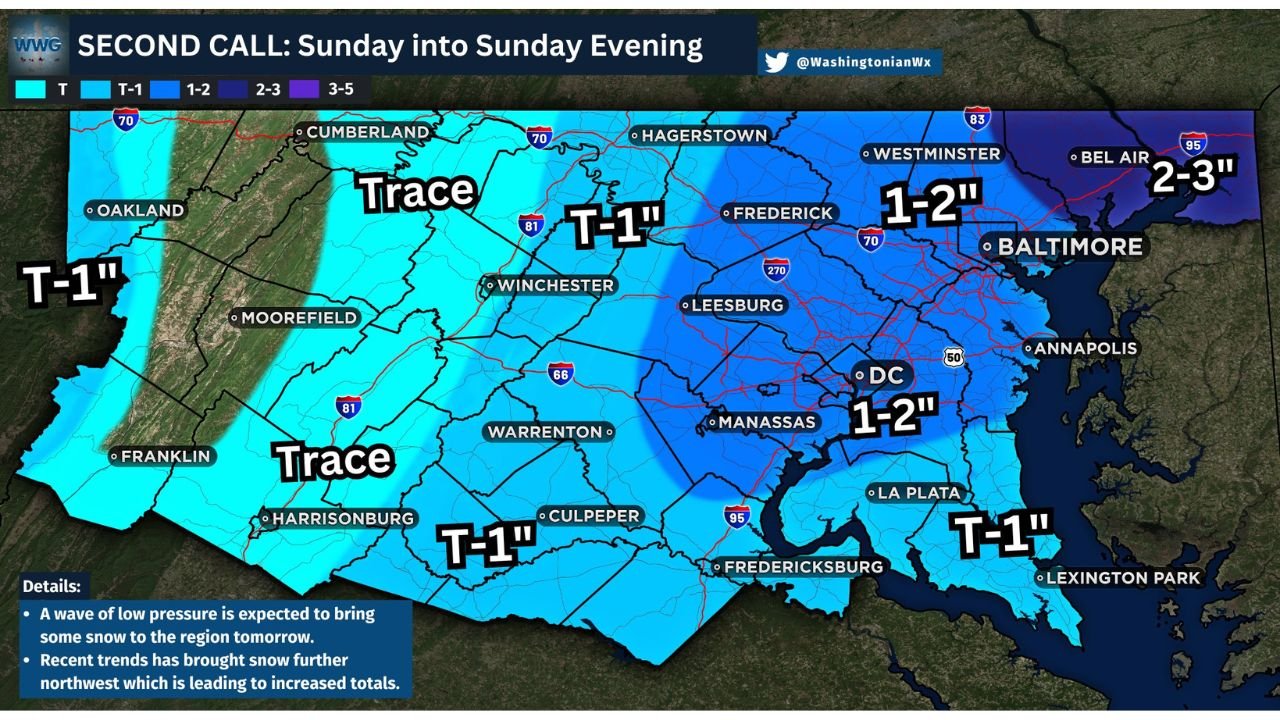
MARYLAND — Forecasters have issued a second-call snow map for the Mid-Atlantic, increasing snowfall expectations across the Baltimore–Washington metro area and introducing a new 2–3 inch snowfall zone across Northeast Maryland as confidence grows in a colder, more snow-favorable setup.
While this system is still not expected to produce a major winter storm, updated trends show greater snow coverage and slightly higher totals, especially north and east of Washington, D.C., where colder air is more firmly in place.
What Changed in the Latest Forecast
The updated forecast reflects recent model trends showing:
- Colder surface temperatures already in place
- Better alignment of precipitation timing with freezing conditions
- A narrow but more persistent band of moderate snow developing during the late morning hours
Because of these factors, snowfall totals across many metro locations have been raised to 1–2 inches, with Northeast Maryland now highlighted for localized 2–3 inch totals.
Expected Snow Totals by Area
Based on the latest second-call map:
- Northeast Maryland (including areas near Bel Air): 2–3 inches
- Baltimore metro: 1–2 inches
- Washington, D.C. metro: 1–2 inches, mainly on grassy and elevated surfaces
- Northern and central Virginia: Trace to 1 inch
- Southern Maryland: Trace to 1 inch
Snow amounts will vary over short distances, especially where heavier bands briefly set up.
Timing: When Snow Will Be Heaviest
Timing remains a key factor in impacts:
- Early morning: Rain and snow mix at onset
- Mid-morning: Transition to primarily snow
- Late morning to early afternoon: Heaviest snowfall rates possible
- 2–4 PM: Snow exits the region from west to east
Even brief heavier bursts could cause temporary reductions in visibility and quick accumulation on untreated surfaces.
Travel Impacts and Safety Concerns
Although snowfall totals remain modest, road and sidewalk conditions could deteriorate quickly due to subfreezing temperatures.
Forecasters warn:
- Slick and icy roads are possible, especially north and west of the Beltway
- Reduced visibility may occur during heavier snow bands
- Bridges, overpasses, and untreated sidewalks are most vulnerable
Anyone traveling during the late morning or early afternoon hours Sunday should allow extra time and use caution.
Why This System Still Matters
This event highlights a classic Mid-Atlantic winter challenge: marginal snow totals combined with cold surfaces. Even small accumulations can lead to outsized impacts, particularly in busy metro corridors.
While this is not a high-end winter storm, the updated forecast signals a higher-impact scenario than previously expected, especially for Northeast Maryland.
Bottom Line
Snow totals have been nudged upward across Maryland, Virginia, and Washington, D.C., with Northeast Maryland now facing the highest accumulation potential. Snow will be short-lived but could create hazardous travel conditions during peak hours.
Stay with Waldron for continued updates as radar trends and final snowfall totals become clearer. If you’re traveling Sunday, plan ahead—and let us know what conditions look like in your area.