
Maryland, Virginia and Washington DC Facing Rare April Heat Surge With 90 Degree Temperatures Possible So Residents Should Prepare Now
MARYLAND — A significant and unusual heat pattern is beginning to take shape across the Mid-Atlantic, with temperatures expected to surge into the 80s by Monday and potentially reach the 90s by midweek, raising concerns about an early-season heat wave.
This shift comes despite it being only mid-April, a time when such heat is not typical for the region.
Temperatures Set to Climb Rapidly Early Next Week
Forecast data indicates a steady warming trend:
- Monday: Highs climbing into the 80s across much of the region
- Tuesday through Thursday: Widespread upper 80s to low 90s possible
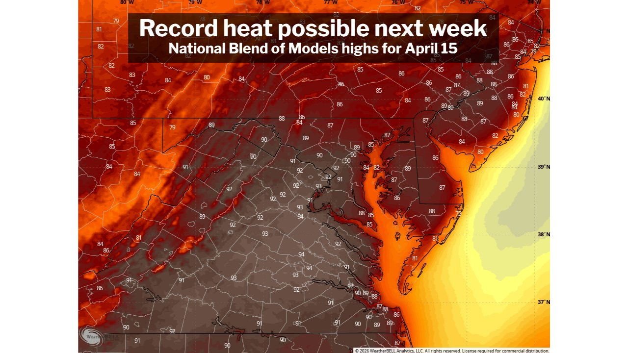
- Multiple days could reach or exceed the 90-degree mark
If these projections hold, this would mark one of the earliest appearances of 90-degree temperatures in recent years.
Washington DC Could See Earliest 90s Since 2013
In Washington DC specifically, the timing of this heat is notable.
- The average first 90-degree day typically occurs around mid-May
- This upcoming stretch could bring 90s nearly a month earlier than normal
- The last similar early occurrence was in 2013, when temperatures hit 91°F on April 10
This places the current setup among the more unusual early-season heat events on record.
Records Could Be Challenged Midweek
Several daily record highs are now within reach:
- Tuesday: Record near 91°F (set in 1960)
- Wednesday: Record near 89°F (set in 1941)
- Thursday: Record near 92°F (set in 2002)
With forecast highs pushing into the low 90s, at least some of these records could be tied or broken, especially if cloud cover remains limited.
Heat Extending Across the Mid-Atlantic Region
This is not just a localized event for Washington DC.
The heat is expected to impact a broader area including:
- Northern Virginia
- Central and Southern Maryland
- Portions of the Delmarva Peninsula
- Surrounding Mid-Atlantic communities
The map data shows widespread upper 80s to low 90s across inland areas, with slightly cooler conditions closer to the immediate coastline.
Pattern Suggests Warmer Than Normal Second Half of April
Beyond this initial heat surge, the broader pattern continues to lean warm:
- Above-normal temperatures likely to persist into late April
- Day-to-day intensity may vary, but overall trend remains elevated
- Additional warm spells cannot be ruled out
This aligns with a larger-scale shift toward a warmer-than-average pattern across the eastern United States.
What Makes This Event Stand Out
Early-season heat waves can be impactful because:
- Many people are not yet acclimated to high temperatures
- Cooling systems may not be fully in use
- Sudden temperature swings can stress infrastructure and health
Even a short-lived period of 90-degree weather in April can feel significantly more intense than similar temperatures later in summer.
Final Outlook
A potentially record-challenging heat surge is expected across Washington DC, Maryland, and Virginia next week, with multiple days of near or above 90-degree temperatures possible.
While exact highs will depend on cloud cover and timing, the signal for unusually early heat is strong.
Residents across the Mid-Atlantic should begin preparing for summer-like conditions arriving far earlier than usual.
Stay with WaldronNews.com for continued updates as this early-season heat event develops.