
Maryland, Virginia, Pennsylvania See Massive Temperature Swings With 80 Degree Warmth Followed By Sharp Cooldown Into April
MARYLAND, VIRGINIA, PENNSYLVANIA — A dramatic temperature rollercoaster is unfolding across the Mid-Atlantic, with forecasters highlighting one of the most volatile March patterns in recent memory. Recent trends show rapid warming toward near 80 degrees early next week, followed by a sharp cooldown that could bring temperatures crashing back into the 40s and 50s as April begins.
The shift comes after an already extreme fluctuation earlier this month, where Baltimore experienced a staggering 52-degree temperature drop within just 24 hours between March 11 and March 12 — a sign of how unstable this pattern has become.
Extreme Temperature Gradient Already Visible Across The Region
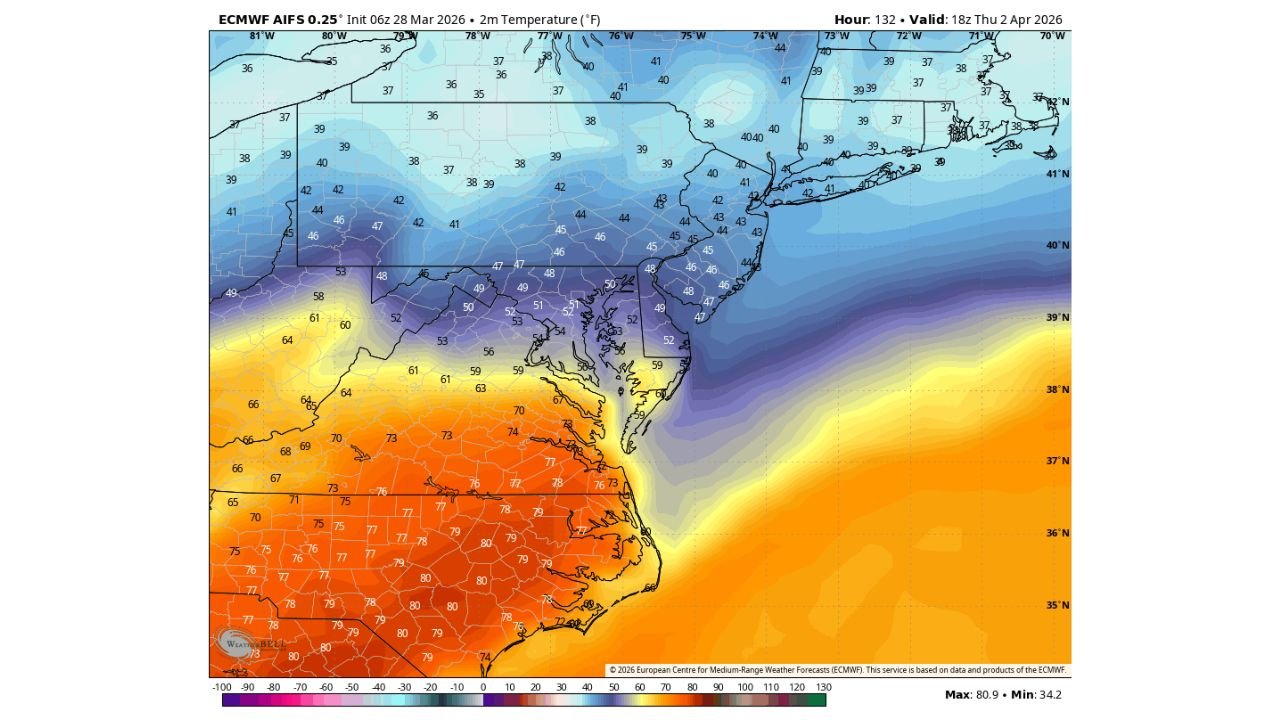
Latest model data shows a sharp contrast stretching across the eastern United States. While the southern Mid-Atlantic, including parts of Virginia and North Carolina, warms into the upper 70s and near 80 degrees, areas just to the north — including Pennsylvania, New York, and New England — remain locked in much cooler air in the upper 30s to low 40s.
This tight gradient highlights a strong boundary separating warm and cold air masses, setting the stage for rapid swings over short periods.
Temperature Trend Visualization
Below is a simplified temperature trend showing how conditions are expected to swing through the upcoming week:
Baltimore Trend Shows Wild March Pattern Continuing
Baltimore has become a prime example of this unstable pattern. After already seeing a historic 52-degree drop in a single day earlier this month, the city is now expected to:
- Climb toward upper 70s to near 80°F early next week
- Then drop sharply back into the 40s and 50s by the end of the week
This kind of rapid fluctuation is uncommon even for March, signaling a highly active atmospheric setup.
What’s Driving These Sudden Swings
The ongoing pattern is being driven by:
- Fast-moving weather systems
- Strong temperature contrasts between northern and southern air masses
- Repeated frontal passages across the Mid-Atlantic
Each system temporarily pushes warm air northward before quickly allowing colder air to surge back in, creating these dramatic back-and-forth changes.
What To Expect Moving Into April
As this pattern continues, residents across Maryland, Virginia, and Pennsylvania should prepare for:
- Rapid day-to-day temperature swings
- Warm, almost summer-like conditions followed by chilly resets
- Continued volatility as the season transitions
This back-and-forth trend is expected to remain active into early April, meaning the region may not settle into consistent spring weather just yet.
Final Outlook
The Mid-Atlantic is entering a period of extreme temperature variability, with near-80-degree warmth quickly giving way to much cooler air. After already seeing dramatic swings earlier in March, the upcoming week reinforces that the pattern is far from over.
Residents should stay prepared for rapid changes — because in this setup, today’s warmth can quickly turn into tomorrow’s chill.
Stay Ahead Of Rapid Weather Changes
Get real-time severe weather updates, detailed forecasts, and interactive data insights only on WaldronNews.com. Follow along for the latest developments and share what you’re seeing in your area to help others stay informed.