
Maryland, Virginia, West Virginia, and Washington, D.C. Face Clear but Bitterly Cold Night as Temperatures Drop Into the Teens and Low 20s
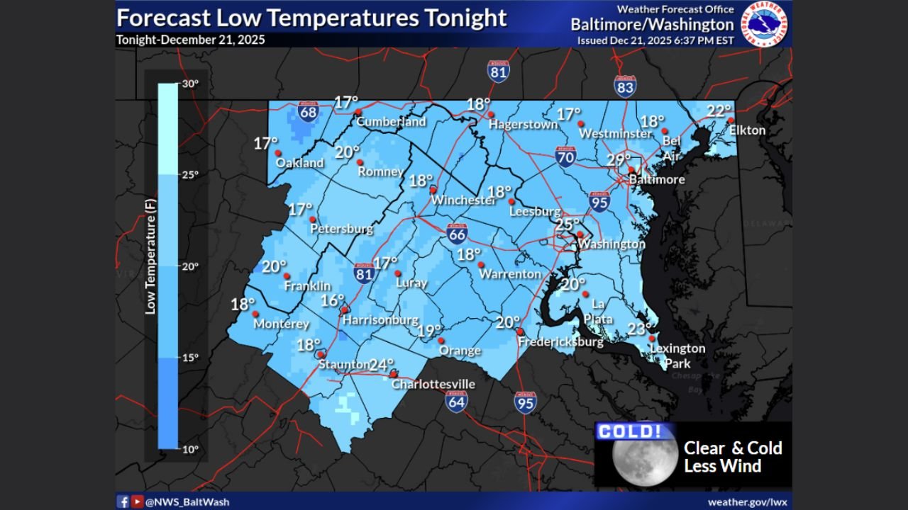
MID-ATLANTIC — A sharp cold snap is settling across Maryland, Virginia, West Virginia, and the Washington, D.C. area tonight as skies clear and winds ease, allowing temperatures to fall rapidly into the mid to upper teens and low 20s, according to the National Weather Service.
Forecasters say the combination of diminishing winds and clear skies will create ideal conditions for strong overnight cooling, making this one of the coldest nights so far this season for many communities across the region.
“Clear and cold tonight as winds diminish.”
Coldest Temperatures Expected in Western Maryland, West Virginia, and the Shenandoah Valley
Forecast low-temperature maps show the coldest readings concentrated west of the Blue Ridge, including portions of western Maryland, eastern West Virginia, and the Shenandoah Valley of Virginia.
Many locations in these areas are expected to see overnight lows between 16 and 20 degrees, with a few sheltered valleys potentially dipping into the mid-teens by early morning.
Urban Areas Slightly Milder but Still Well Below Freezing
While colder air will dominate the entire region, urban centers along the I-95 corridor — including Baltimore and Washington, D.C. — are expected to remain slightly milder due to residual heat retention.
Even so, overnight lows in these metro areas are forecast to fall into the mid to upper 20s, well below freezing and cold enough to refreeze any remaining moisture on roads and sidewalks.
“It will be cold everywhere — just less extreme in the cities.”
Sunny but Cool Conditions Expected Monday
After the frigid overnight temperatures, Monday will bring sunny skies across much of the region, with clouds gradually increasing later in the day.
Despite the sunshine, temperatures will remain cool, with afternoon highs generally reaching the upper 30s to mid-40s, keeping a winter feel firmly in place.
Winds are expected to stay lighter than recent days, helping conditions feel more manageable during daylight hours.
Travel and Safety Concerns Overnight
Officials urge residents to take precautions as temperatures fall:
- Protect exposed pipes and pets
- Use caution on bridges and untreated roads where refreezing may occur
- Dress in layers if heading out late or early
The cold may be especially noticeable during the early morning commute before temperatures rebound slightly after sunrise.
Cold Pattern Remains in Control for Now
While no major winter storms are imminent in the immediate forecast, the presence of cold air across the Mid-Atlantic means future systems could bring wintry precipitation if moisture returns later in the week.
Forecasters will continue monitoring temperature trends and potential storm development.
“Cold air is in place — the next system will determine what happens next.”
Are temperatures dropping sharply where you live tonight? Share your local conditions and stay updated with regional weather coverage at WaldronNews.com.