
Massachusetts and Rhode Island Braced for 40+ Inches as Intense Deformation Band Parks Over Boston–Providence Corridor
MASSACHUSETTS & RHODE ISLAND — An extremely intense deformation band has locked into place over eastern Massachusetts and northern Rhode Island, and forecasters warn that someone in this zone could surpass 40 inches of snowfall before the storm fully winds down.
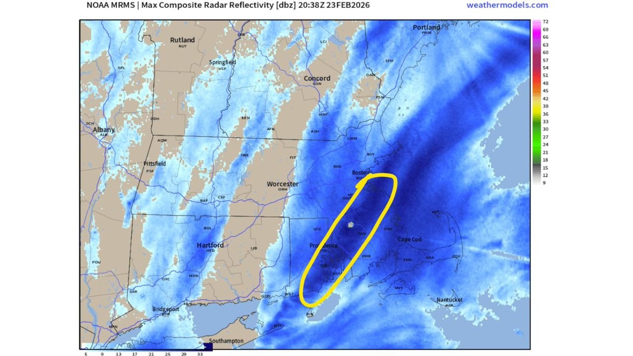
High-resolution NOAA MRMS radar imagery late February 23 shows a narrow but powerful stripe of extreme snowfall rates stretching from near the South Coast of Massachusetts northward through Providence, RI, and into the Boston metro area.
Meteorologists say this type of banding is capable of producing historic totals in a very localized corridor.
Where the Heaviest Snow Is Falling
The deformation band — highlighted on radar — is aligned roughly southwest to northeast, cutting across:
- Providence, Rhode Island
- Southeastern Massachusetts
- Boston, Massachusetts
- Areas just west of Cape Cod
Radar reflectivity imagery shows persistent high-intensity returns within this narrow zone, indicating extremely heavy snowfall rates. These bands can dump several inches per hour when fully established.
Meanwhile, cities just west of the band — including Hartford, Connecticut, Worcester, Massachusetts, and Albany, New York — are seeing snow, but not at the same relentless intensity.
Why 40 Inches Is Possible
A deformation band forms where air masses collide and lift intensely in a pivoting storm system. Once established, the band can remain nearly stationary for hours.
That appears to be happening between Boston and Providence.
If snowfall rates of 2–4 inches per hour persist, totals could rapidly climb into extreme territory. Meteorologists analyzing the radar signature suggest that at least one location within this band is likely to exceed 40 inches before the storm exits.
Such totals would rank among the highest ever recorded in parts of Massachusetts and Rhode Island.
Sharp Cutoffs Nearby
One of the defining features of this storm is the tight snowfall gradient.
- Areas directly inside the band may see 30–40+ inches.
- Locations just 20–30 miles west could end up with significantly lower totals.
- Coastal sections of Cape Cod and the Islands remain outside the most intense banding.
This sharp contrast underscores how localized extreme snowfall can be during powerful nor’easters.
Boston–Providence Corridor Under the Gun
The Boston metro area, including communities south and southwest of the city, remains directly under the heaviest radar returns.
Providence and surrounding Rhode Island communities are also in the core zone, with the band extending down toward the South Coast of Massachusetts.
If the band stalls for several more hours, parts of this corridor could face crippling totals, major transportation shutdowns, and prolonged power disruptions.
A Storm That Keeps Escalating
Earlier forecasts called for significant snowfall across southern New England, but the current radar trends suggest that the highest-end projections may be realized — or even exceeded — in this narrow axis.
Meteorologists emphasize that once deformation banding locks in, snowfall amounts can rapidly outpace expectations.
Residents in eastern Massachusetts and Rhode Island are urged to remain indoors, avoid travel, and prepare for continued heavy snowfall through the remainder of the event.
WaldronNews.com will continue providing updates as totals climb and the storm evolves across southern New England.