
Meteorologists Warn That 2026 Tornado Season Could Be Unusually Quiet Across the Central and Southern U.S., New Forecast Maps Suggest
UNITED STATES — Long-range climate models are signaling an unusually suppressed severe weather pattern for spring 2026, raising early concerns that the upcoming tornado season across states such as Kansas, Oklahoma, Texas, Arkansas, and Missouri could be significantly weaker than normal. New data from the CFSv2 forecasting system, paired with upper-air pattern outlooks, paints a picture of a strongly ridged, stable atmosphere—a setup that historically limits tornado activity.
The maps circulated widely by meteorologists this week show a rare alignment: below-average precipitation, suppressed storm energy, and a dominant high-pressure ridge cutting across the heart of Tornado Alley.
A Ridge-Dominated Pattern That Disrupts Severe Weather Formation
Forecast charts for May 2026, a core month for tornado activity, show widespread warm-toned height anomalies—a sign of persistent high pressure aloft. This kind of atmospheric ridge typically:
- Reduces storm development
- Limits deep moisture return from the Gulf
- Weakens instability needed for strong supercells
- Pushes the jet stream north, away from the Plains
The result is a season that may struggle to produce the kind of storm patterns typically associated with significant tornado outbreaks.
“The 2026 tornado season is cancelled,” one meteorologist wrote while sharing the maps, adding that the Plains appear “ridged out and reduced to atoms.”
While the phrase is dramatic, the underlying science supports a quieter-than-normal scenario.
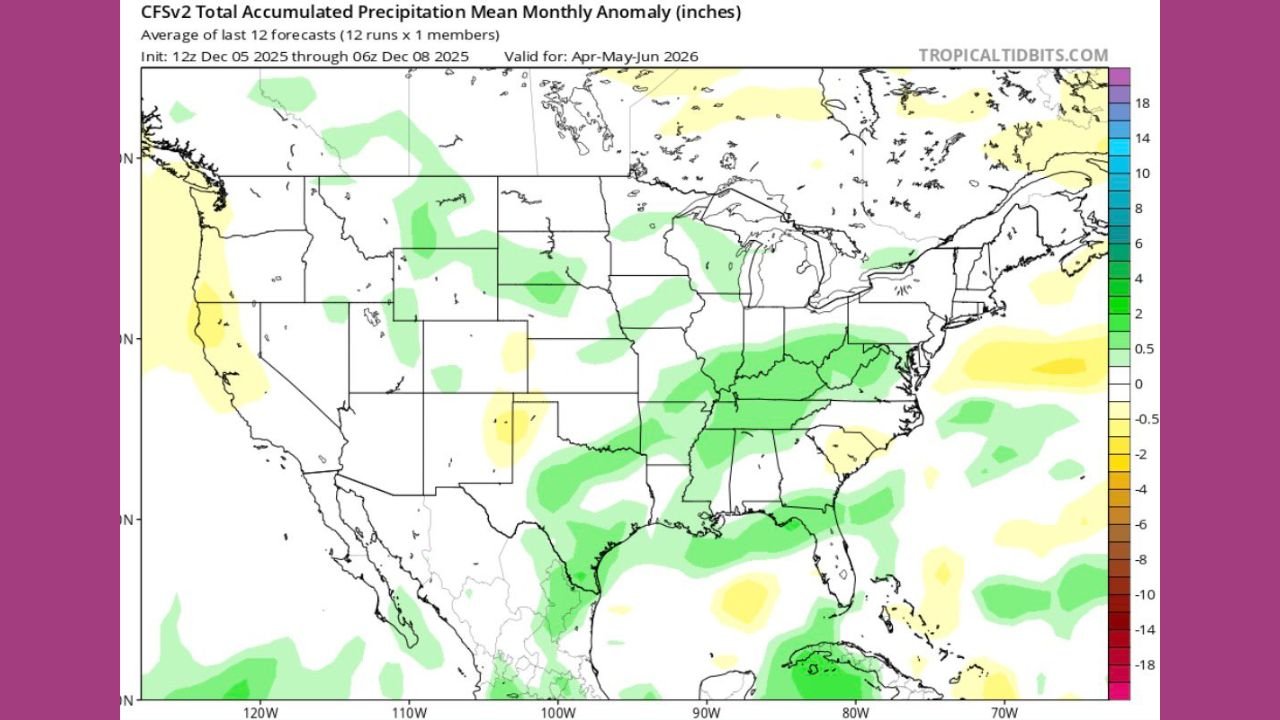
Precipitation Maps Show Weak Storm Signals Across the Plains
The CFSv2 precipitation anomaly graphics show large zones of below-average rainfall from the Central Plains through the Midwest—an indicator of:
- Fewer storm systems
- Less organized severe weather outbreaks
- Limited moisture and instability
Meanwhile, above-average precipitation appears more consistent across the Gulf Coast and parts of the Midwest, suggesting displaced storm tracks.
These precipitation trends line up closely with the persistent upper-air ridging seen in the 500 mb charts.
Atmospheric Heights Show Strong Warm Anomalies Across Tornado Alley
The geopotential height anomaly maps—a critical piece of severe weather forecasting—reveal a dominant ridge stretching across the U.S., including:
- Texas
- Oklahoma
- Kansas
- Arkansas
- Missouri
Lower tornado seasons tend to occur when stable upper-level ridges suppress rising motion and weaken storm shear. These patterns have shown up in most model runs through early December, adding confidence to the long-range signal.
Meteorologists emphasize that while no forecast 5–6 months out is absolute, all major indicators so far point to a quieter season.
Why This Matters for Residents Across the Central and Southern U.S.
A suppressed tornado season may sound like a relief, but it also:
- Increases drought potential in parts of the Plains
- Could reduce water availability for agriculture
- Shifts storm risks to other regions, especially the Southeast
- May create late-season volatility if atmospheric patterns flip suddenly
Experts caution that one major outbreak can still occur in a low-activity season, meaning preparedness remains essential.
What Happens Next?
Meteorologists will continue monitoring:
- Jet stream placement
- Gulf moisture trends
- ENSO (El Niño/La Niña) patterns
- Springtime atmospheric shifts
If the current ridging signal holds, spring 2026 may enter the record books as one of the less active tornado seasons in recent memory.
But as always in severe weather science, long-range patterns can change quickly.
Stay Updated With Waldron News
For ongoing severe weather updates, long-range climate forecasts, and safety coverage across the United States, visit WaldronNews.com regularly. Stay informed, stay prepared, and stay safe.