
Michigan, Illinois, Arkansas and Wisconsin Face Rare Multi-Threat Storm as Tornadoes, Blizzard, Ice and Fire Weather Collide Across the United States
UNITED STATES — A massive and complex storm system is expected to sweep across the country this weekend, bringing a rare combination of dangerous weather hazards at the same time, including tornado-producing storms in Arkansas and Illinois, blizzard conditions in Wisconsin and Michigan, ice storm risks in northern Michigan, and dangerous fire weather in parts of the Plains.
Meteorologists monitoring the system say it could become one of the most impactful spring storms of the season, affecting millions of people from Texas and Arkansas to Michigan and the Northeast.
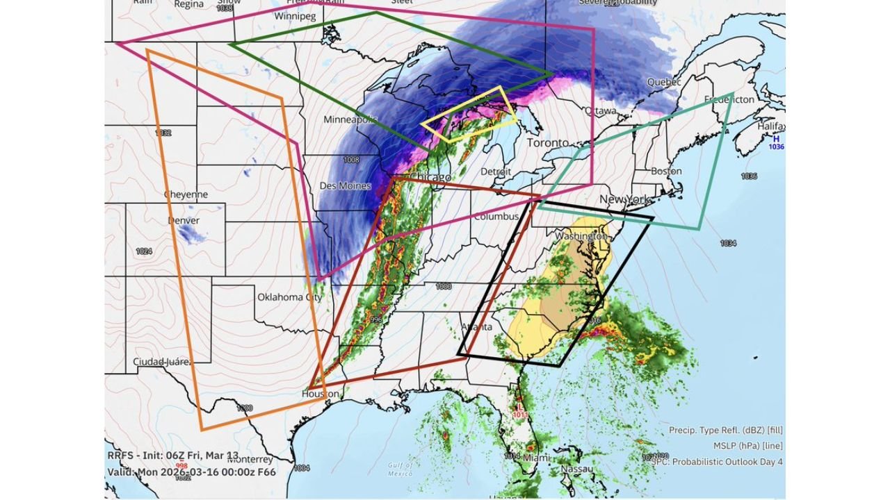
Forecast maps show the powerful storm organizing across the central United States before intensifying as it moves toward the Great Lakes, producing dramatically different weather conditions depending on location relative to the storm’s center.
Tornado-Producing Storms Possible from Texas and Arkansas to Illinois
On the southern side of the storm, warm and unstable air flowing north from the Gulf of Mexico could fuel a dangerous line of severe thunderstorms stretching from Texas through Arkansas into Illinois.
Forecasters say this system could evolve into a QLCS — a fast-moving squall line capable of producing tornadoes and destructive winds.
Areas most likely to experience severe storms include:
- Eastern Texas
- Arkansas
- Missouri
- Illinois
- Western Tennessee
Cities such as Little Rock, Memphis, St. Louis, and Chicago could see strong storms capable of producing:
- 60–75 mph damaging winds
- Brief tornadoes embedded in the squall line
- Heavy rain and lightning
The most intense storms may develop Sunday afternoon and evening, when atmospheric instability and strong wind shear overlap.
Blizzard Conditions Expected Across Wisconsin and Michigan
North of the storm’s center, temperatures will be much colder, allowing precipitation to fall as heavy snow.
Forecast guidance suggests blizzard conditions could develop across parts of Wisconsin and Michigan, particularly near Lake Superior and the Upper Peninsula.
Meteorologists say snowfall totals in the heaviest bands could reach 10 to 30 inches, accompanied by strong winds capable of producing:
- Whiteout conditions
- Severely reduced visibility
- Dangerous travel conditions
Cities that may experience the worst winter conditions include:
- Marquette, Michigan
- Green Bay, Wisconsin
- Ironwood, Michigan
- Duluth, Minnesota
Strong winds combined with heavy snowfall could make travel nearly impossible in some areas.
Northern Michigan Could Face Dangerous Ice Storm
Between the heavy snow zone and the rain region, a dangerous ice storm risk may develop across parts of northern Michigan.
In this transition zone, temperatures near the surface may remain below freezing while warmer air moves in above the ground.
This setup could allow freezing rain to accumulate on trees, roads, and power lines, potentially creating:
- Hazardous travel conditions
- Downed power lines
- Widespread power outages
Communities near northern Lower Michigan and parts of the Upper Peninsula could face the highest risk of icing.
Fire Weather Threat in the Southern Plains
Meanwhile, behind the storm system across parts of the southern Plains, dry air and strong winds may create dangerous wildfire conditions.
Meteorologists warn that Texas, Oklahoma, and parts of New Mexico could experience critical fire weather, with strong winds and low humidity increasing the risk of rapidly spreading wildfires.
Officials are urging residents in those areas to avoid outdoor burning and remain alert for fire warnings.
Storm Expected to Impact Much of the United States
Forecast models show the storm rapidly strengthening as it tracks northeast through the Mississippi Valley into the Great Lakes, impacting a huge portion of the country.
Major cities potentially affected include:
- Chicago, Illinois
- Detroit, Michigan
- Memphis, Tennessee
- St. Louis, Missouri
- Little Rock, Arkansas
Because the storm includes multiple weather hazards occurring at the same time, meteorologists are describing it as a “kitchen sink” storm system capable of producing nearly every type of severe weather hazard.
Meteorologists Urge Residents to Stay Alert
With the storm still several days away, meteorologists stress that exact locations of the most dangerous weather may shift as the forecast evolves.
However, early indications suggest that millions of Americans could experience severe storms, blizzard conditions, dangerous icing, or extreme winds as the powerful system moves through.
Residents across affected regions are encouraged to monitor forecasts closely and prepare for rapidly changing weather conditions through the weekend.
Stay with WaldronNews for continuing updates as meteorologists track this powerful storm threatening Michigan, Illinois, Arkansas, Wisconsin and much of the United States.