
Michigan Leads Eastern U.S. Snowfall Totals as Early-Season Snow Blankets Most States, New Data Shows
WALDRON, MICHIGAN — New national snowfall data from NOAA/NOHRSC reveals that most of the United States has already seen accumulating snow by early December — and Michigan now stands out as the snowiest location east of the Rocky Mountains, driven by persistent lake-effect bands and early-season storm systems.
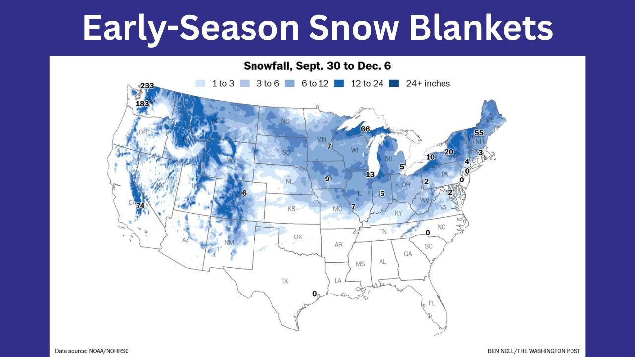
From September 30 to December 6, the heaviest eastern U.S. snowfall was recorded in Ishpeming, Michigan, which has already accumulated 66 inches, placing it among the highest totals in the entire country for the early winter period.
Snow Has Fallen in Nearly Every Northern State Already
The national snowfall map shows widespread accumulation across the northern half of the United States:
- Michigan: 66 inches in Ishpeming; widespread totals of 10–20 inches across lower Michigan.
- Minnesota: 7–13 inches across most of the state.
- Wisconsin: 5–15 inches from north to central regions.
- New York: Up to 55 inches in parts of the Adirondacks and northern tier counties.
- Pennsylvania & Ohio: 2–10 inches depending on elevation and proximity to the Great Lakes.
Even lower-elevation regions in the Midwest and Northeast have seen measurable snowfall during this early-season stretch.
West Leads the Nation: Washington’s Mt. Baker Records 233 Inches
While Michigan leads the eastern U.S., the snowiest location in the entire country remains:
- Mt. Baker, Washington — 233 inches
- Other high snowfall zones include:
- 183 inches in Idaho’s higher elevations
- 74 inches in the Sierra Nevada of California
These totals reflect the strong Pacific storm track and early-season atmospheric river activity feeding persistent snowfall into the western mountains.
Why Michigan Is Seeing Such High Totals
Meteorologists credit the Upper Peninsula’s early-season snowfall surge to:
- Cold air crossing the still-unfrozen Great Lakes
- Persistent lake-effect snow bands
- Multiple clipper systems sweeping across the Great Lakes region
Ishpeming, located in the central U.P., is frequently positioned in the heart of these snow belts, allowing totals to stack up quickly.
Most States Now Have Some Snow on the Ground
According to NOAA’s data:
- Nearly every northern state has recorded at least 1–3 inches.
- States like North Dakota, South Dakota, Wyoming, and Colorado show widespread 6–12+ inch zones.
- The only areas with zero accumulation so far include much of the South, Southeast, and parts of the interior West.
This widespread coverage signals that winter has arrived early and aggressively for much of the U.S. this season.
What This Means Heading Into Late December
Forecasters warn that early-season snowpack, especially across the Upper Midwest and Great Lakes, can:
- Intensify cold air outbreaks
- Increase the potential for lake-effect snowstorms
- Boost the risk of hazardous travel periods approaching the holidays
With Michigan already seeing winter in full force, meteorologists say another significant pattern shift could bring additional rounds of lake-effect and system-driven snow through mid-December.
Stay Informed
WaldronNews.com will continue monitoring snowfall changes, winter storm alerts, and updated federal climate data as the season unfolds.
For weather updates affecting Michigan and the surrounding region, follow Waldron News online and on social media.