
Michigan, Minnesota and Wisconsin Brace for 24-Inch Snow Threat as Powerful Winter Storm Targets Upper Great Lakes Near Canadian Border
MICHIGAN — A powerful winter storm is wrapping moisture northwest into entrenched cold air across the Upper Great Lakes, setting the stage for widespread snowfall and potentially extreme totals near the U.S.–Canada International Border.
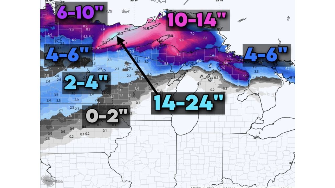
Forecast guidance shows the heaviest snow focusing across northern Minnesota, northern Wisconsin, and especially Michigan’s Upper Peninsula, where localized totals could approach two feet before the system pulls away.
Heavy Snow Expands Northwest Into Cold Air
This storm is dynamically pulling Atlantic moisture back into colder air already locked in over the region. That northwest “wraparound” effect is allowing snow to expand and persist longer across the Upper Midwest.
Snow is expected across:
- Northern Minnesota
- Northern Wisconsin
- Upper Peninsula of Michigan
- Portions of northern Lower Michigan
The interaction between moisture and deep cold air is the primary driver of higher-end totals.
Highest Totals Near the International Border
The most significant snowfall is projected closest to the Canadian border, where cold air depth and moisture overlap most efficiently.
Current projections indicate:
- 6–10 inches widespread across northern Minnesota, northern Wisconsin, and much of the U.P.
- 10–14 inches common within stronger banding zones
- 14–24 inches possible in parts of Michigan’s Upper Peninsula
Localized amounts could exceed projections if heavier snow bands stall.
Sharp Snowfall Gradient Moving South
Snow totals are expected to decrease significantly farther south:
- 4–6 inches across parts of central Wisconsin and northern Lower Michigan
- 2–4 inches in surrounding transition areas
- 0–2 inches in southern portions where forcing weakens
This sharp cutoff highlights how tightly aligned the heavy snow axis is with the deeper cold air to the north.
Why the Upper Peninsula Is Most Vulnerable
Several atmospheric ingredients are favoring extreme totals in the Upper Peninsula:
- Strong wraparound moisture
- Sustained cold air in place
- Persistent banding near Lake Superior
- Slow storm progression
That combination supports prolonged moderate to heavy snowfall, especially in higher elevations and lake-influenced areas.
Travel and Impact Concerns
Communities including Marquette, Houghton, Sault Ste. Marie, Ironwood, and northern Minnesota border towns should prepare for:
- Snow-covered and slick roadways
- Reduced visibility in heavier bursts
- Potential drifting where winds increase
Even areas expecting 4–6 inches could experience hazardous travel during peak snowfall periods.
Final Outlook
This system demonstrates how efficiently moisture converts to heavy snowfall when cold air is firmly established. The greatest impacts appear focused across northern Minnesota, northern Wisconsin, and especially Michigan’s Upper Peninsula, where totals could approach two feet.
Stay with WaldronNews.com for continued updates as snowfall projections are refined and impact zones become clearer.