
Michigan, Ohio and Indiana Face Slight Risk of Severe Storms Tuesday With Damaging Winds, Large Hail and Tornado Threat Targeting Chicago, Detroit, Toledo and Cleveland
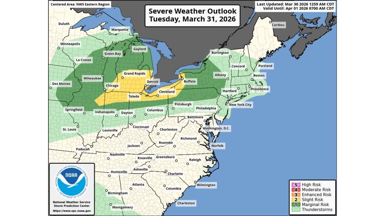
DETROIT, MICHIGAN — A Slight Risk of severe weather is in place across a large swath of the Midwest and Great Lakes for Tuesday, March 31, 2026, with the Storm Prediction Center issuing an outlook valid through April 1, 2026 at 7:00 AM CDT. Communities across Michigan, Ohio, Indiana and Illinois — including major metro areas of Chicago, Detroit, Toledo, Cleveland, Grand Rapids and Buffalo — are in the yellow Level 2 Slight Risk zone, meaning scattered severe storms are expected during Tuesday’s afternoon and evening hours. All severe hazards are on the table for this event, and forecasters are particularly focused on the tornado threat given the strong wind shear profiles in place.
Cities and States in the Severe Weather Zone
Level 2 Slight Risk — Tuesday March 31:
- Michigan: Detroit, Grand Rapids, Ann Arbor, Flint, Kalamazoo
- Ohio: Toledo, Cleveland, Columbus, Dayton, Akron
- Indiana: Indianapolis and northern Indiana communities
- Illinois: Chicago metro and surrounding northeastern Illinois
- New York: Buffalo corridor
Level 1 Marginal Risk — broader surrounding area:
- Wisconsin: Milwaukee and Green Bay
- Pennsylvania: Pittsburgh corridor
- Kentucky and Tennessee: northern fringe communities
- New York and New England: Albany through Connecticut corridor
Primary Threats Tuesday
All severe weather hazards appear possible across the Midwest and Great Lakes Tuesday:
- Damaging winds — the primary threat, with gusts capable of downing trees and power lines across Michigan, Ohio and Indiana
- Large hail — the secondary significant threat for the Chicago to Cleveland corridor
- Tornado threat — strong wind shear profiles could support rotating thunderstorms and a conditional threat of a strong tornado cannot be ruled out
- Heavy rainfall — embedded within the storm complex moving through the region
- Reduced visibility during the heaviest storm activity
The HRRR model initialized Monday March 30 at 12Z shows the storm system arriving across the Michigan and Ohio area by 4:00 PM CDT Tuesday, with intense storm cells — shown in deep red and purple on the radar simulation — concentrated across Lower Michigan, northern Ohio and the Lake Erie corridor toward Buffalo, New York.
Why the Tornado Threat Cannot Be Dismissed
What makes Tuesday’s setup more than just a typical wind and hail event is the wind shear profile in place across the region. The HRRR atmospheric sounding for the Michigan and Ohio area Tuesday afternoon shows:
STP (Significant Tornado Parameter) of 2.4 — a value above 1.0 is considered notable for tornado potential. A reading of 2.4 places this setup in a range where supercell thunderstorms with tornado potential are a realistic outcome if storms can tap into the most favorable atmospheric layer.
In plain language — the atmosphere on Tuesday afternoon across Michigan, Ohio and Indiana will have enough spin, enough moisture and enough energy to support a strong tornado if the right storm can get organized. This does not mean tornadoes are guaranteed or even likely for every community in the risk zone. It means that if you live in the Slight Risk zone covering Detroit, Toledo, Cleveland, Grand Rapids and Chicago, you need to take this seriously and have a plan.
What This Means for Chicago, Detroit and Cleveland Residents
For residents of Chicago, Illinois — you are on the western edge of the Slight Risk zone. Storms arriving from the west Tuesday afternoon could bring damaging winds and large hail to the metro area. The tornado threat is lower but not zero for the Chicago metro.
For residents of Detroit, Michigan and Toledo, Ohio — you are in the heart of the Slight Risk zone. This is where the HRRR model is showing the most intense storm activity by mid-afternoon Tuesday. Both damaging winds and the tornado threat are meaningful for your communities. Know your shelter location before Tuesday afternoon.
For residents of Cleveland and Akron, Ohio — you are also in the Slight Risk zone with a tornado-capable environment. The storm complex tracking from Michigan could arrive organized and intense by Tuesday evening.
For residents of Buffalo, New York — you are in the Slight Risk zone on the eastern edge of the system. Storms could still be organized and severe by the time they reach your area late Tuesday.
Multi-Day Pattern: More Active Weather Ahead
Tuesday’s severe weather event is part of a broader active spring pattern that is expected to continue through the first week of April. Residents across the Midwest and Great Lakes should not let their guard down after Tuesday — additional storm chances are in the forecast heading into the April 2 through 4 timeframe, with some days carrying even more significant severe weather potential than Tuesday for portions of the Midwest and South.
What to Watch Next
- Tuesday afternoon storm initiation — whether storms fire organized or in a more scattered line across Michigan and northern Indiana
- SPC watches — watch for possible tornado watches to be issued for Michigan, Ohio and Indiana Tuesday afternoon
- Storm motion — storms are expected to track northeastward, meaning Toledo and Cleveland could see the heaviest activity in the late afternoon to early evening hours
- Buffalo corridor timing — organized storm cells could reach western New York by Tuesday evening
- Post-Tuesday pattern — whether Thursday April 2 delivers a more significant severe weather event for a different corridor
Residents across Chicago, Illinois, Detroit and Grand Rapids, Michigan, Toledo, Cleveland and Columbus, Ohio, Indianapolis, Indiana and Buffalo, New York should have weather alerts enabled on mobile devices, know their shelter locations and monitor NWS Storm Prediction Center updates closely throughout Tuesday.
WaldronNews.com will continue tracking Tuesday’s severe weather threat across Michigan, Ohio, Indiana and Illinois and provide updates on watches, warnings and storm reports as the event unfolds.