
Michigan Snowfall Surges Past Normal as Parts of Ottawa, Kent, and Allegan Counties Near 50 Inches in January
MICHIGAN — January 2026 turned into one of the snowiest starts to winter in years for Michigan, with new analysis showing extreme snowfall totals across western and central parts of the state, especially along the Lake Michigan shoreline.
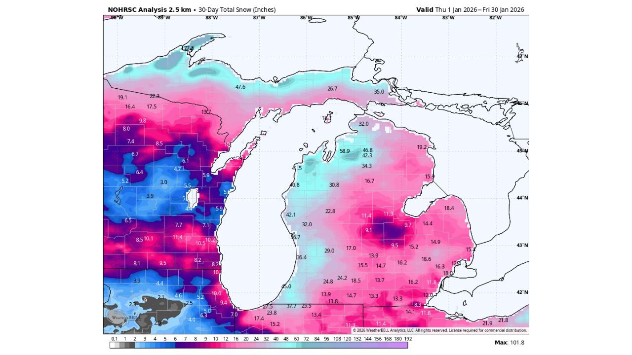
According to NOAA’s NOHRSC 30-day snow analysis, parts of Ottawa, Kent, and Allegan counties recorded close to 50 inches of snow during January alone, with nearly 80 percent of that snowfall occurring in just the final two weeks of the month. The data highlights how relentless lake-effect snowstorms dominated the second half of January, rapidly piling up snow across already cold ground.
West Michigan Hit Hardest as Lake-Effect Snow Dominates
The most intense snowfall was concentrated in west-central Michigan, where persistent northwest wind flow off Lake Michigan fueled repeated lake-effect snow bands.
- Ottawa County: Snow totals pushed toward the 45–50 inch range, especially inland from the lakeshore
- Kent County: Widespread totals of 35–45 inches, with localized higher pockets
- Allegan County: Several areas approaching 40–50 inches, particularly in rural zones
Snowfall intensity increased sharply after mid-January, with repeated overnight events allowing accumulation to stack faster than melting or compaction could reduce it.
Snowfall Patterns Show Sharp County-to-County Contrast
The snowfall map shows dramatic gradients across Michigan, a hallmark of lake-effect events:
- Western Lower Peninsula: Deep pink and purple shading indicates 30–50+ inches
- Central Michigan: Totals generally ranged from 15–30 inches
- Eastern Michigan: Significantly lower totals, many areas staying under 20 inches
This uneven distribution explains why travel and infrastructure impacts were far more severe in western counties, while areas farther east saw more manageable winter conditions.
Late-Month Snow Bursts Drove January Totals
Meteorologists noted that roughly four-fifths of January’s snowfall fell during the last two weeks, a period marked by:
- Sustained cold air outbreaks
- Favorable lake-effect wind direction
- Minimal thawing between snow events
Because temperatures remained well below freezing for extended stretches, snowpack depth steadily increased instead of settling, leading to unusually high monthly totals.
Why This Matters for the Rest of Winter
With a deep snowpack already in place, western Michigan faces heightened risks moving into February:
- Continued lake-effect snow could add rapidly to already high totals
- Snowmelt flooding concerns may rise later if temperatures warm suddenly
- Transportation and supply delays remain possible in rural counties
Officials urge residents to remain prepared for continued winter weather impacts, especially in snow-belt regions where accumulation can spike with little notice.
What are snowfall totals like where you live this winter?
Share your local snow numbers and photos with us, and stay updated on winter weather coverage at Waldronnews.com.