
Michigan, Wisconsin, and Midwest Face Major Freezing Rain Threat as Ice Storm Could Trigger Widespread Power Outages
MICHIGAN — A potentially dangerous freezing rain storm is developing across the Midwest, with forecast models indicating significant ice accumulation across Michigan, Wisconsin, and parts of Iowa and Illinois from Sunday through Monday night. Meteorologists warn that the storm could create hazardous travel conditions and trigger widespread power outages, especially as strong winds arrive late Monday.
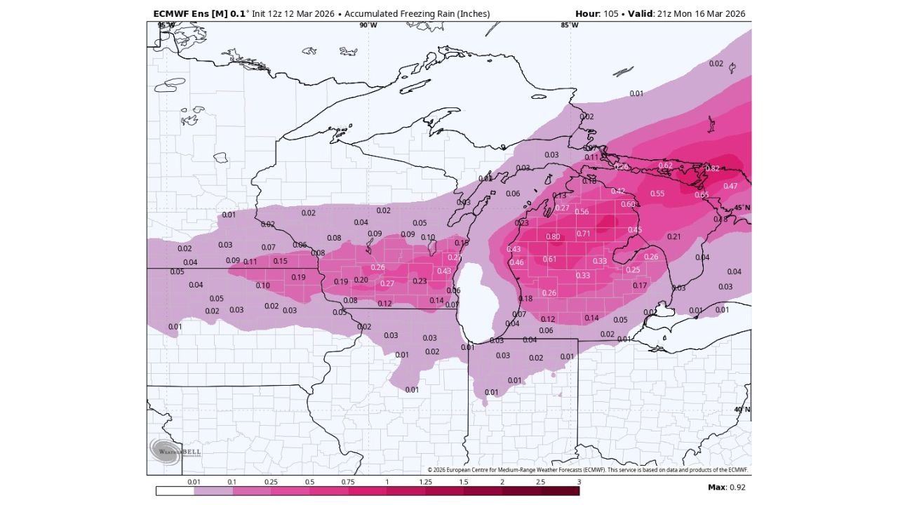
Forecast guidance shows a broad swath of freezing rain stretching across the Great Lakes region, with Michigan appearing to be one of the hardest-hit states as ice accumulation intensifies across central and northern areas.
Ice Accumulation Could Become Significant Across Michigan
Weather model projections indicate that much of Michigan may experience freezing rain, with the heaviest ice potential stretching across central portions of the state.
Some areas could see ice accumulation between 0.30 and 0.80 inches, which is enough to coat roads, trees, and power lines with thick layers of ice.
Communities across central and northern Michigan appear most vulnerable, including areas near:
- Traverse City
- Grayling
- Mount Pleasant
- Alpena
- Saginaw Valley region
Ice totals approaching three-quarters of an inch are possible in some locations, which can create dangerous conditions similar to major ice storms seen in the region during past winters.
Wisconsin and Northern Midwest Also in the Ice Zone
The freezing rain threat is not limited to Michigan. The storm system may also spread dangerous icing conditions across parts of Wisconsin, northern Illinois, and eastern Iowa.
Model guidance shows a band of moderate icing extending across:
- Southern Wisconsin
- Eastern Iowa
- Northern Illinois
Ice totals in these areas could reach 0.15 to 0.30 inches, which is still enough to create slippery roads and cause tree limbs to sag under the weight of ice.
Cities such as Madison, Milwaukee, Rockford, and Cedar Rapids could experience periods of freezing rain during the storm.
Strong Winds Monday Night Could Worsen Damage
One of the biggest concerns with this system is the combination of ice and strong winds expected Monday night.
When winds increase after significant ice buildup, tree branches and power lines become much more vulnerable to snapping. This scenario has historically led to large-scale power outages during Midwest ice storms.
If the forecast holds, the region could face a dangerous setup where:
- Trees become coated with ice during the day
- Winds strengthen later in the storm
- Heavy branches and power lines begin to fail
Utility crews across the region are likely to monitor the storm closely as the situation evolves.
Why Freezing Rain Is So Dangerous
Freezing rain occurs when rain falls through a layer of cold air near the ground and freezes instantly on contact with surfaces.
Unlike snow or sleet, freezing rain forms solid sheets of ice that cling to roads, sidewalks, vehicles, and infrastructure.
Even small amounts can cause major problems:
- 0.10 inches can make roads extremely slippery
- 0.25 inches can begin damaging trees and power lines
- 0.50 inches or more can produce widespread outages
Some parts of Michigan in this forecast zone could approach those higher levels.
Travel Conditions Could Become Hazardous
Drivers across the region may face dangerous road conditions if freezing rain develops as expected.
Bridges, overpasses, and untreated roads often freeze first, creating hidden ice known as “black ice.”
Travel could become especially dangerous across:
- Central Michigan highways
- Rural Wisconsin roads
- Northern Illinois interstates
Officials may issue winter weather alerts if confidence continues to increase in the icing forecast.
Storm Timing: Sunday Through Monday
Current projections suggest the freezing rain threat will begin Sunday and continue into Monday, with icing potentially intensifying through the event before winds increase later Monday night.
However, freezing rain forecasts can shift depending on temperature changes of only a few degrees, meaning the exact placement of the heaviest icing could still change.
Meteorologists are continuing to monitor updates closely.
Residents Urged to Prepare Early
Residents across the Midwest should prepare for the possibility of an impactful winter weather event by:
- Charging phones and backup batteries
- Securing outdoor items that could be affected by wind
- Avoiding unnecessary travel during freezing rain
- Monitoring local weather alerts
Ice storms can quickly create dangerous conditions, especially when strong winds follow heavy ice accumulation.
As the storm approaches, forecasters will refine the details of where the most severe icing could occur across Michigan and neighboring Midwest states.
Stay with WaldronNews for continuing updates on this developing freezing rain storm and other major weather events across the United States.