
Michigan Wisconsin Minnesota Blizzard Aftermath as 52 Inch Snow Buries Round Lake and Historic March Storm Smashes Expectations Across the Great Lakes
MICHIGAN — The powerful March 2026 blizzard has officially come to an end, but its impact is being described as far more intense than originally forecast. Snowfall totals across the Great Lakes region exceeded expectations in several areas, with parts of Michigan recording staggering accumulations that rival some of the biggest March snow events on record.
Snow Totals Surpass Forecasts Across the Region
What began as a major winter storm quickly turned into a historic event as snowfall totals came in higher than even the most aggressive projections.
Across Minnesota, Wisconsin, and Michigan, widespread heavy snow blanketed the region, with bands of intense snowfall producing:
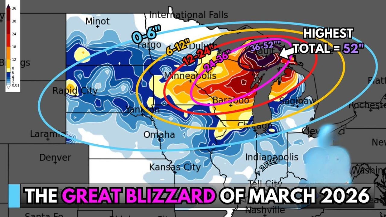
- 12 to 24 inches across large portions of Wisconsin and Minnesota
- 24 to 36 inches in more concentrated zones
- Localized areas pushing into 36 to 52 inches near the Upper Great Lakes
This placed parts of the region firmly in extreme snowfall territory.
Michigan Sees Jaw-Dropping 52 Inch Snow Total
The most extreme total reported from this storm came out of Round Lake, Michigan, where snowfall reached an incredible 52 inches.
That is:
- More than 4 feet of snow
- Enough to bury vehicles and severely impact structures
- One of the highest snowfall reports from this event
This level of accumulation is rarely seen, especially in a single March storm.
Blizzard Core Targeted Upper Midwest and Great Lakes
The heaviest snow band set up from:
- Central Minnesota
- Through Wisconsin
- Into northern Michigan and the Upper Peninsula
This corridor experienced the most intense snowfall rates and longest duration, leading to extreme totals.
Meanwhile, surrounding areas including parts of the Dakotas, Iowa, Illinois, and Indiana saw lighter but still impactful snowfall totals ranging from a few inches up to a foot or more.
Impacts Felt Across Multiple States
The storm’s reach extended well beyond just one state, affecting travel and daily life across a wide region.
Major impacts included:
- Snow-covered roads and difficult travel conditions
- Deep snow accumulation in residential areas
- Disruptions across multiple Midwest states
In hardest-hit zones, the snow depth created significant cleanup challenges.
Major Warm-Up Could Trigger Rapid Snowmelt
While the snowstorm has ended, attention is now turning to what comes next.
Forecasts indicate a major temperature warm-up later this week, with highs expected to climb into the 60s across parts of the region.
This could lead to:
- Rapid snowmelt
- Increased runoff and localized water issues
- A quick transition from winter conditions to early spring
From Blizzard to Thaw in Just Days
The contrast between extreme snowfall and upcoming warmth highlights the volatile nature of March weather in the Midwest.
After delivering historic snow totals and shutting down parts of the region, the atmosphere is now preparing for a dramatic shift toward milder conditions.
What Happens Next
Residents across Michigan, Wisconsin, and Minnesota should prepare for changing conditions as melting begins. While the snowstorm phase is over, the aftermath will continue to impact daily life for days to come.
This event will likely be remembered as one of the most intense March blizzards in recent years.
Stay with WaldronNews.com for continued coverage of this historic storm and its aftermath across the Great Lakes region.