
Mid-April Severe Weather Watch Now Emerging Across Plains And Midwest As New Storm Pattern Targets Texas Oklahoma Kansas Missouri And Iowa
UNITED STATES — A new weather signal is beginning to take shape that could bring another active round of severe storms across the central U.S. by mid-April, following a brief period of calmer conditions.
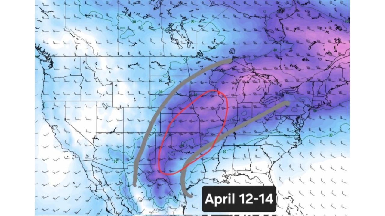
Forecast guidance highlights a developing corridor of concern from Texas and Oklahoma through Kansas, Missouri, and into Iowa, with early indications pointing toward April 12–14 as a window to watch closely.
Short Break Before Next Active Pattern Begins
After the current stretch of severe weather, conditions are expected to:
- Transition into a short-lived stable period
- Bring temporary relief across much of the Plains and Midwest
- Last only a few days before the atmosphere becomes active again
This pause will not last long, as new energy is already being projected to build across the region.
Strong Signal For Severe Weather Setup April 12–14
Long-range model trends show:
- A defined storm corridor forming from the Southern Plains into the Midwest
- Increasing moisture and instability spreading northward
- A setup supportive of organized storm systems rather than isolated activity
The highlighted risk zone includes:
- North Texas
- Oklahoma
- Kansas
- Missouri
- Iowa
This region is already being flagged as a potential focal point for stronger storm development.
Pattern Suggests Large-Scale Storm System Potential
Unlike scattered pop-up storms, this setup appears more organized, with:
- A broad south-to-north storm track
- Favorable conditions for multiple rounds of storms
- Potential for widespread impacts across multiple states
The orientation of the system suggests storms could track northeast, affecting areas farther into the Midwest over time.
Early Indicators Point To Heavy Rain And Severe Risk
Forecast models are showing:
- A concentrated band of precipitation stretching from Texas into the Midwest
- Signals of stronger storm cores embedded within this zone
- Potential for heavy rainfall and severe weather hazards
While exact threats are still uncertain this far out, setups like this can eventually support:
- Damaging winds
- Large hail
- Tornado potential depending on how the system evolves
Central U.S. Should Begin Monitoring Trends Now
Even though this is still several days away, the consistency in model signals means:
- This is not a one-off projection
- Confidence is increasing that an active pattern will return
- Details will become clearer as we get closer to the event window
Residents across the Plains and Midwest should begin preparing for another round of potentially impactful weather.
Key Areas To Watch
The highest early concern is focused along a corridor including:
- Dallas–Fort Worth and North Texas
- Oklahoma City and central Oklahoma
- Wichita and central Kansas
- Kansas City metro (Missouri/Kansas)
- Des Moines and parts of Iowa
This region may shift slightly in the coming days, but it represents the current core of concern.
More Details Will Emerge In Coming Days
As the atmosphere evolves:
- Forecast models will refine timing and severity
- Risk zones may expand or shift
- Confidence in specific hazards will increase
For now, this should be treated as an early heads-up for a developing severe weather pattern.
Stay with WaldronNews.com for ongoing updates, forecast tracking, and early alerts as this mid-April severe weather setup continues to develop across Texas, Oklahoma, Kansas, Missouri, and Iowa.