
Mid-April Storm Pattern Alert Issued for Texas, Oklahoma, Arkansas, Missouri, Illinois and Ohio Valley Farmers
UNITED STATES — A new mid-April weather alert has been issued for the Southern Plains into the Ohio Valley, as forecast models signal a return to an active storm pattern that could significantly impact agriculture and daily conditions across multiple states.
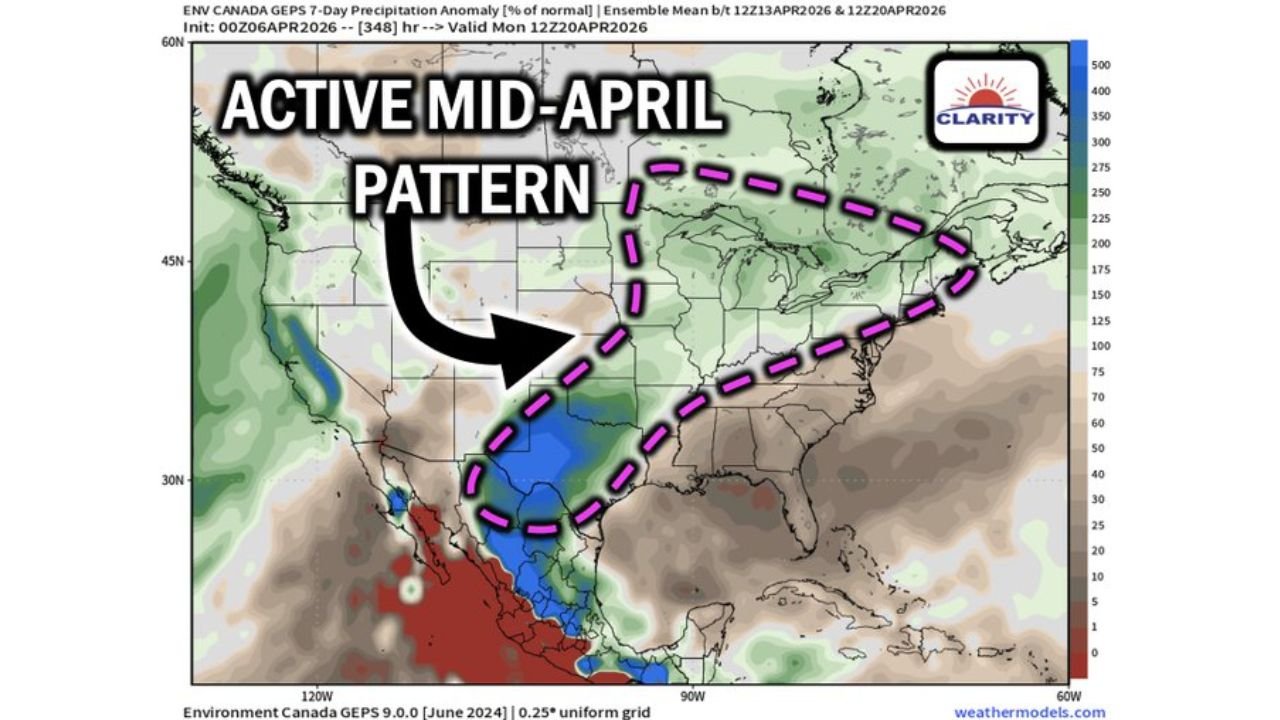
The latest data highlights a large corridor of increased storm activity stretching from Texas through Oklahoma, Arkansas, Missouri, Illinois, and into the Ohio Valley, raising concerns about frequent rainfall, storm systems, and limited dry periods.
Active Storm Corridor Taking Shape
Forecast guidance shows a well-defined storm track developing across the central United States, with the most active zone including:
- Texas
- Oklahoma
- Arkansas
- Missouri
- Illinois
- Indiana and Ohio Valley regions
This pattern is being driven by a persistent flow of moisture and repeated storm systems, creating a setup where multiple rounds of rain and storms are likely over several days.
Rainfall Increasing Across Key Agricultural Areas
The precipitation outlook suggests:
- Above-normal rainfall spreading from the Southern Plains into the Midwest
- Heaviest activity focused from North Texas through Oklahoma into Missouri and Illinois
- Continued storm chances extending into the Ohio Valley
This means many areas could see repeated rainfall events rather than a single storm system, increasing the likelihood of soil saturation and field delays.
Major Concern: Limited Planting Windows
One of the biggest impacts of this developing pattern is on agriculture.
- Frequent rain and storms will reduce available dry periods
- Field conditions may remain too wet for planting operations
- Farmers could face tight or delayed planting windows through mid-April
This is especially critical across the Corn Belt transition zone and Southern Plains, where timing is essential for early-season planting.
Why This Pattern Matters
The upcoming setup is not just a short-term event. It represents a multi-day active pattern, meaning:
- Storm systems may arrive one after another
- Dry breaks between systems could be very limited
- Ground conditions may worsen with each passing system
This kind of pattern often leads to compounding impacts, especially in regions already dealing with earlier moisture or unstable conditions.
Regions Most at Risk for Disruptions
The highest concern zone includes:
- North Texas and Central Texas
- Oklahoma and Arkansas
- Missouri and Illinois
- Extending into Indiana and Ohio
These areas fall directly under the highlighted active storm corridor, making them most vulnerable to repeated rainfall and operational disruptions.
What Residents and Farmers Should Expect
As this pattern develops, impacts may include:
- Frequent rain events and thunderstorms
- Short-lived dry breaks between systems
- Possible localized flooding in heavier rainfall zones
- Ongoing delays for agricultural activities
Even outside peak rainfall zones, the overall pattern remains unsettled, meaning conditions may stay unpredictable.
Timing of the Active Pattern
The shift toward this active setup is expected to begin around mid-April, with impacts continuing through multiple days during that period.
This timing aligns with a critical window for agricultural operations, increasing the importance of closely monitoring conditions.
Situation Requires Close Monitoring
This developing weather pattern across Texas to the Ohio Valley is one that demands attention due to its duration, coverage, and potential impacts.
With repeated storm chances and limited dry windows, both residents and farmers should prepare for an extended period of unsettled weather.
Stay with WaldronNews.com for continued updates as this mid-April storm pattern evolves and impacts expand across the central United States.