
Mid Atlantic and Northeast States From Virginia Maryland Pennsylvania New Jersey to New York Could See First 90 Degree Heat Next Week So Residents Should Watch This Rare Early Season Surge
UNITED STATES — A significant early-season heat signal is emerging across parts of the Mid-Atlantic and Northeast, with data indicating that the first 90-degree temperatures of the year could arrive next week, marking one of the earliest occurrences in decades.
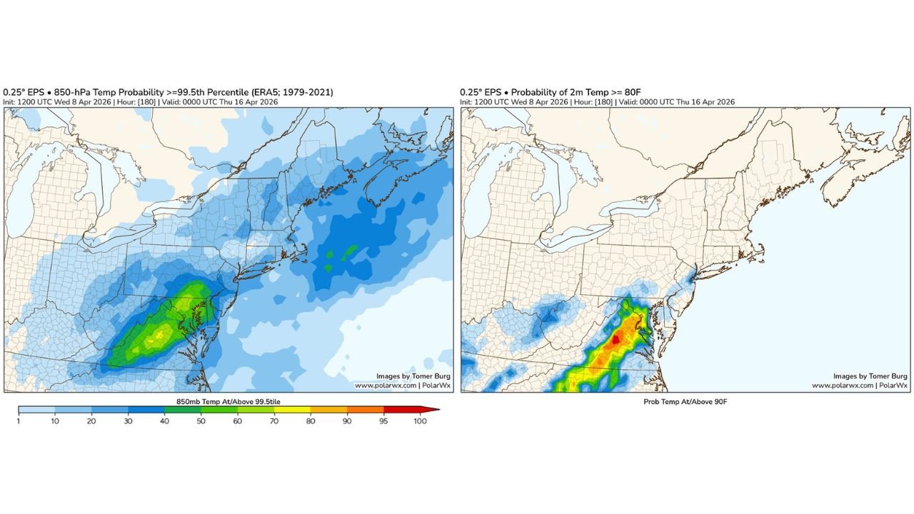
Forecast probability maps show a concentrated zone of unusual warmth stretching from the southern Mid-Atlantic into parts of the Northeast, highlighting the potential for a notable temperature spike.
Core Heat Zone Focused Over Mid-Atlantic
The highest probability for extreme warmth is centered across:
- Virginia
- Maryland
- Washington D.C. region
- Delaware
- Southern Pennsylvania
- New Jersey
This region shows the strongest signal for temperatures reaching or exceeding 90 degrees, especially during the midweek period.
Rare Early Season Heat Signal Emerging
The data suggests this event could rank among the earliest 90-degree readings since 1978, making it a highly unusual April heat event.
Key indicators include:
- Extremely high percentile temperature anomalies at upper levels
- Strong probability signals for surface temperatures exceeding 80°F and pushing toward 90°F
- A concentrated corridor of peak warmth aligned with the Mid-Atlantic region
This level of early-season heat is uncommon and stands out in long-range climate comparisons.
Northeast Sees Elevated But Slightly Lower Risk
Areas farther north, including:
- New York
- Connecticut
- Massachusetts
are also expected to experience warmer-than-normal conditions, though the probability of reaching 90°F decreases compared to the Mid-Atlantic.
Still, these regions could see:
- Significant early warmth
- Temperatures well above seasonal averages
- A noticeable shift from typical April conditions
What Is Driving This Warm Surge
The pattern behind this heat event is linked to:
- Strong upper-level ridging building over the eastern United States
- Warm air advection pushing northward from the south
- Favorable atmospheric alignment supporting heat accumulation
These factors combine to create a setup capable of producing unusually high temperatures for this time of year.
Why This Matters
An early-season heat surge can have broader impacts, including:
- Increased stress on those unaccustomed to summer-like temperatures
- Early strain on cooling systems
- Accelerated plant growth and seasonal transitions
The sudden jump from typical spring conditions to near-summer heat can catch many off guard.
Timing of the Heat Event
The peak of this heat is expected:
- Around mid to late next week
- Likely centered between Tuesday and Thursday
- With the strongest signals focused on Wednesday
Exact timing may shift slightly, but confidence is growing in a midweek warm surge.
Final Outlook
The Mid-Atlantic and parts of the Northeast are trending toward a potentially historic early-season heat event, with some areas possibly reaching 90 degrees for the first time this year.
If realized, this would mark one of the earliest such events in decades, particularly across Virginia, Maryland, and nearby states.
Residents across these regions should prepare for a sudden shift to summer-like conditions next week.
Stay with WaldronNews.com for updates as this unusual April heat pattern continues to develop.