
Mid-Atlantic Braces for Dangerous Overnight Cold as Wind Chills Drop Below Zero Across Maryland, Virginia, D.C., and West Virginia
UNITED STATES — A powerful dome of high pressure settling over the Mid-Atlantic is setting the stage for one of the coldest nights of the winter season, with temperatures plunging into the single digits for many areas and sub-zero wind chills expected in parts of Maryland, Virginia, Washington, D.C., and West Virginia late tonight into early Saturday.
Meteorologists say clear skies, calm to occasionally breezy winds, and strong Arctic high pressure will combine to allow heat to rapidly escape after sunset. As a result, conditions will become dangerously cold, especially in higher elevations and rural areas.
Temperatures Drop Into the Single Digits — Colder in the Mountains
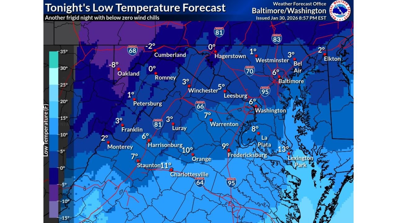
Forecast low temperatures across much of central and northern Maryland, northern Virginia, and the D.C. metro area are expected to fall into the mid to upper single digits, with some sheltered locations briefly touching the lower single digits.
Along the Allegheny Front and western highlands, conditions will be even more extreme. Overnight lows there are forecast to dip below zero, with some locations potentially reaching -5°F to -8°F before sunrise.
Wind Chills Fall Below Zero for Many
Even light winds will dramatically worsen conditions. Wind chill values are expected to fall below 0°F across wide portions of western Maryland, eastern West Virginia, and the higher terrain of Virginia. Some ridge-top and valley locations could experience wind chills nearing -10°F overnight.
Closer to Baltimore, Washington, and surrounding suburbs, wind chills are forecast to range from -5°F to 5°F, cold enough to cause frostbite on exposed skin in as little as 30 minutes.
Why This Cold Is So Dangerous
Unlike brief cold snaps, this event is driven by persistent Arctic air, meaning temperatures will remain well below normal even after sunrise. Daytime highs on Saturday are expected to struggle into the 20s to low 30s, offering little relief.
Officials warn that the cold poses serious risks to:
- Unprotected pipes, which could freeze and burst
- Outdoor pets and livestock
- Unhoused individuals and anyone without adequate heating
- Drivers, especially if vehicles fail to start in the cold
What Residents Should Do Now
Emergency officials urge residents across the Mid-Atlantic to take the cold seriously:
- Dress in multiple layers and cover exposed skin
- Limit time outdoors, especially overnight and early morning
- Bring pets indoors
- Check on elderly neighbors
- Allow faucets to drip and insulate vulnerable plumbing
- Keep space heaters away from flammable materials
Cold Persists, Then Gradual Moderation
While tonight will be the coldest period, temperatures are expected to remain below seasonal averages through the weekend. A slow moderation is possible early next week, though forecasters caution that additional cold air intrusions remain possible as winter patterns stay active across the eastern United States.
Residents are encouraged to monitor local forecasts and weather alerts as conditions evolve.
Stay with WaldronNews for continued weather updates, safety guidance, and developing forecasts as this dangerous cold grips the region.