
Mid-Atlantic States Including Pennsylvania, New Jersey, Maryland, and Virginia Likely to Turn Colder Late December Into New Year’s as Models Show Cold Returning
MID-ATLANTIC UNITED STATES — Long-range forecast guidance is increasingly signaling a return to colder weather across the Mid-Atlantic during the final days of December and into the start of the New Year, as temperature anomaly data shows cold air diving back into the region after an extended warm stretch.
While no major snowstorms are clearly indicated yet, meteorologists say the pattern shift is notable, especially compared to earlier projections that favored sustained warmth across the eastern U.S.
“Almost all long-range modeling now shows colder air returning to the Mid-Atlantic late December into early January.”
Pennsylvania, New Jersey, Maryland, and Virginia Show Clear Cooling Signal
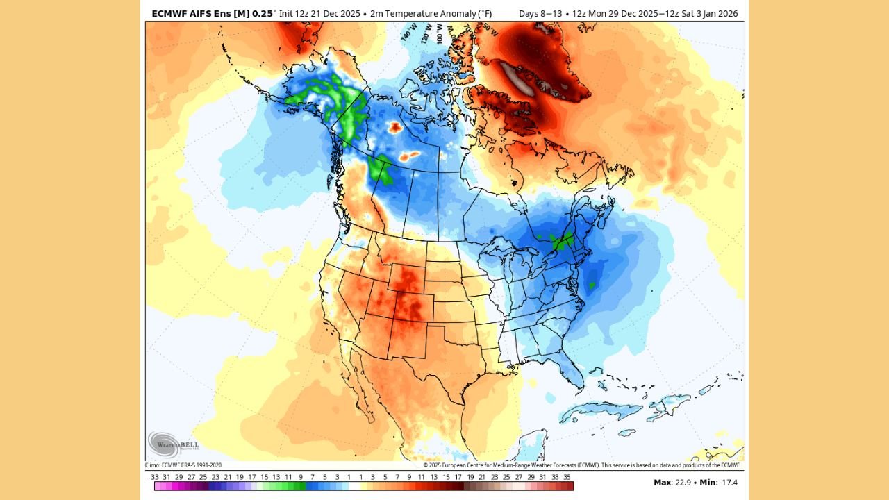
ECMWF ensemble temperature anomaly maps for December 29 through January 3 show a broad area of below-normal temperatures developing across the Mid-Atlantic, including:
- Pennsylvania
- New Jersey
- Maryland
- Virginia
This cooling stands in contrast to warmer-than-normal conditions persisting across the western and southwestern United States during the same period.
The data suggests a more seasonal feel returning to the Mid-Atlantic as the calendar flips to 2026.
No Major Snowstorms Indicated Yet, But Pattern Bears Watching
Despite the colder signal, forecast guidance does not currently show a clear snowstorm threat for the Mid-Atlantic during this window.
Most winter weather events so far this season have been fast-moving Alberta Clipper systems, primarily impacting the Midwest and Great Lakes rather than the East Coast.
“Any snowstorms? Don’t see any yet.”
Forecasters caution, however, that colder air in place increases the region’s vulnerability should a storm system develop later.
Southern Jet Stream Energy Could Become a Factor
Meteorologists note emerging hints of Southern Jet Stream energy around the same timeframe — a feature that historically plays a role in larger East Coast winter storms when cold air is present.
While confidence remains low at this range, the alignment of returning cold air and jet stream activity is something forecasters are closely monitoring.
“Southern jet energy around that time is something to keep an eye on — this is often how big snow setups begin.”
Cold Air Focused on the East as West Stays Warmer
Temperature anomaly data shows a stark contrast across the country, with colder-than-normal air focused east of the Mississippi River while much of the West and Southwest remains warmer than average.
This east-west temperature divide supports a pattern where cold air is more available for the Mid-Atlantic than earlier in the month.
What This Means Heading Into the New Year
For now, the most likely outcome is:
- A return to colder, more seasonal temperatures
- Limited snow chances unless storm systems develop
- Increased monitoring potential as January begins
Forecasters emphasize that long-range winter patterns can evolve quickly, especially once colder air establishes itself.
“Cold air returning is step one. Storms come later.”
Forecast Confidence Will Increase Closer to New Year’s
Meteorologists say confidence will improve as shorter-range models begin resolving details later this week. Any emerging snow threats would likely become clearer within 5–7 days of the event window.
For now, the focus remains on the temperature shift, not a specific storm.
Are you noticing colder air returning where you live in the Mid-Atlantic? Share your local conditions and follow continued winter weather coverage at WaldronNews.com.