
Mid-Atlantic States Including Virginia, Maryland, West Virginia and Pennsylvania Face Highest Snow Risk as Possible Bomb Cyclone Develops Offshore
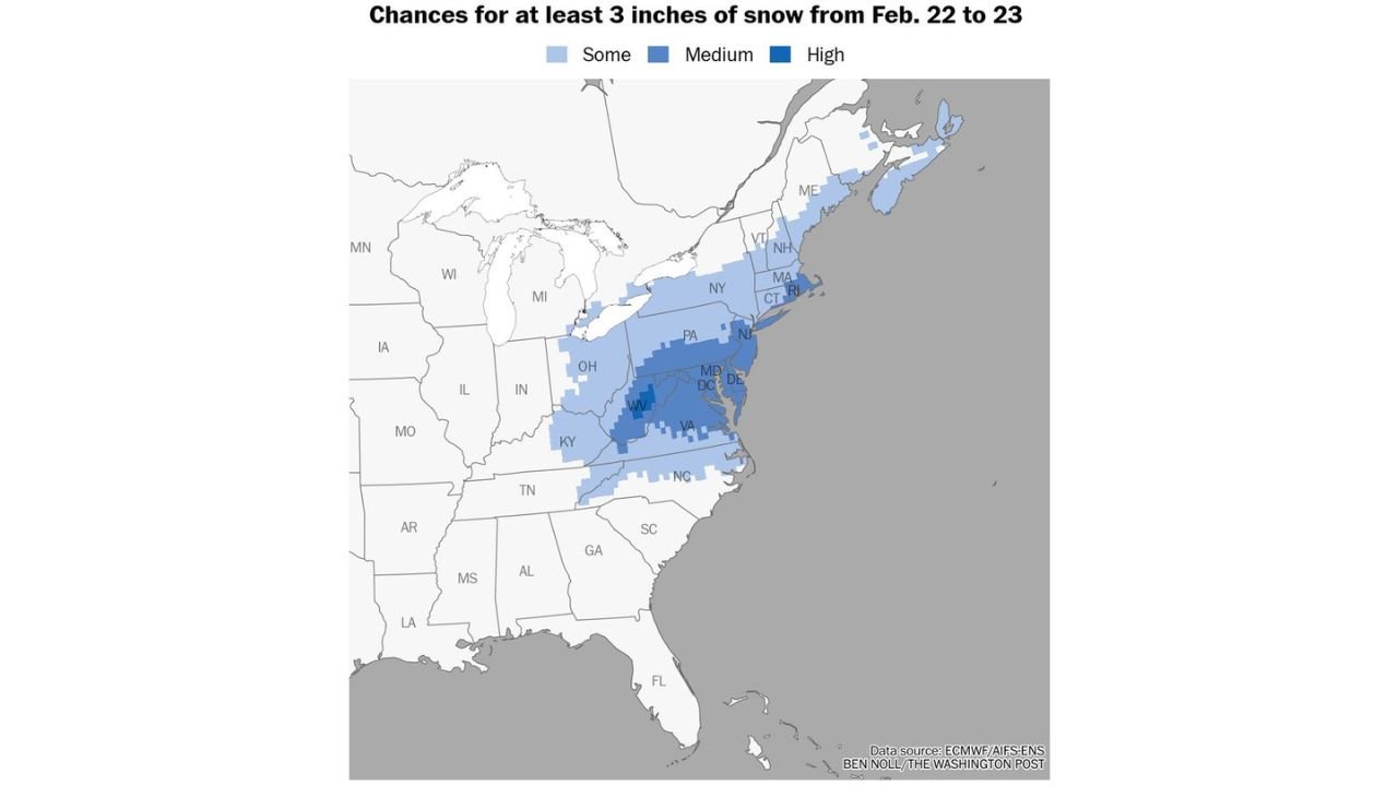
MID-ATLANTIC STATES — The highest probability of at least 3 inches of snowfall Sunday into Monday is currently centered across Virginia, Maryland, West Virginia, Delaware and southern Pennsylvania, as a developing coastal storm threatens to rapidly intensify off the East Coast.
Forecast guidance indicates the Mid-Atlantic has the strongest signal for accumulating snow between February 22 and 23, with snowfall potential extending north into New Jersey, New York and parts of southern New England.
Highest Odds for 3+ Inches Centered Over Virginia, Maryland and West Virginia
Probability mapping shows the most concentrated zone of higher snowfall chances across:
- Central and eastern Virginia
- Maryland, including the Baltimore–Washington corridor
- West Virginia
- Delaware
- Southern Pennsylvania
These areas currently hold the highest odds of reaching or exceeding the 3-inch threshold if the coastal system strengthens as projected.
Lighter but notable chances extend northward into:
- New Jersey
- Eastern Pennsylvania
- New York
- Connecticut, Rhode Island and Massachusetts
Bomb Cyclone Potential Off the Mid-Atlantic Coast
Meteorologists are watching the possibility of a rapidly deepening low-pressure system — often referred to as a bomb cyclone — developing off the Mid-Atlantic coastline before tracking southeast of New England.
If rapid intensification occurs offshore:
- Snowfall rates could increase along the I-95 corridor
- Wind impacts could become a factor
- Coastal communities could see enhanced banding
However, the exact offshore track remains critical.
Storm Track Will Determine Snow Totals
The key question remains: How far offshore does the low track?
- A track closer to the coast would shift heavier snow inland across Maryland, Virginia and Pennsylvania.
- A farther offshore track would reduce totals along the immediate coastline while enhancing snowfall east of the major metro areas.
Small shifts in storm position could significantly change snowfall distribution across the region.
Snow Risk Extends North Into New Jersey and New England
While the Mid-Atlantic currently holds the strongest signal, moderate probabilities extend into:
- New Jersey
- Southeastern New York
- Southern New England, including Connecticut, Rhode Island and Massachusetts
Farther north into northern New England, probabilities taper but still indicate some potential for measurable snowfall.
Timing: Sunday Into Monday
The primary snowfall window is expected from late Sunday through Monday, with accumulation potential depending on storm intensification and coastal proximity.
Travel impacts could develop across:
- Washington, D.C.
- Baltimore
- Richmond
- Philadelphia
- Newark
- New York City
if current trends hold.
Final Outlook for the Mid-Atlantic and Northeast
At this stage, the Mid-Atlantic corridor from Virginia through Maryland and into southern Pennsylvania has the strongest signal for at least 3 inches of snow. The potential development of a bomb cyclone offshore adds uncertainty — and possible upside — to snowfall projections.
Confidence will increase as storm track and strengthening trends become clearer over the coming forecast cycles.
Stay with WaldronNews.com for continuing updates as the coastal storm threat evolves.