
Mid March Cold Air Set to Return to Illinois, Indiana, Ohio, Kentucky, Tennessee, Georgia and the Carolinas After Brief Early March Warm Surge Across the Central and Eastern United States
UNITED STATES — The surge of warmth expected next week across parts of the country will not mark the start of a lasting spring pattern. Long range guidance already signals that colder air is poised to return to much of the central and eastern United States by mid March.
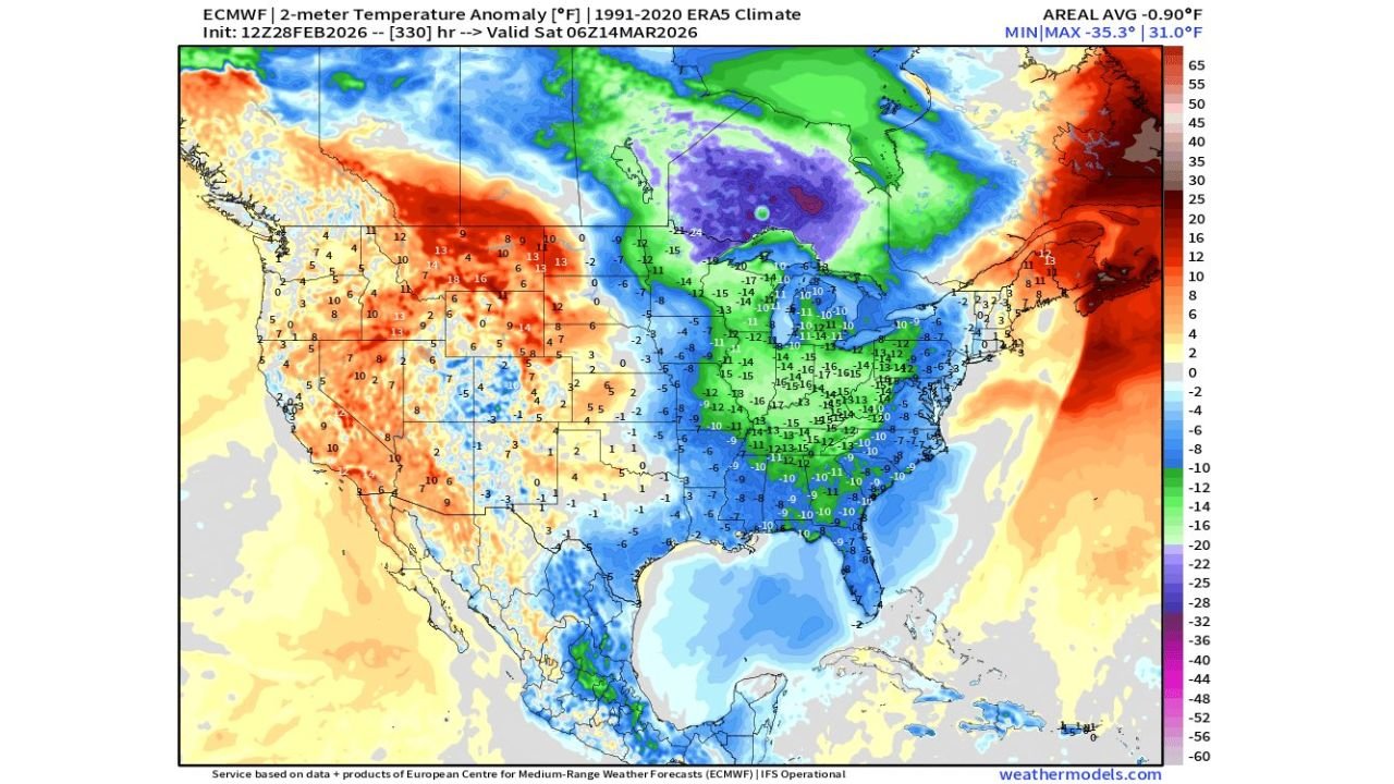
The latest ECMWF temperature anomaly forecast valid around March 14 shows a dramatic reversal compared to the early month warmth.
Cold Air Expands Across the Midwest, Ohio Valley and South
Widespread below normal temperatures are projected across:
- Illinois
- Indiana
- Ohio
- Kentucky
- Tennessee
- Mississippi
- Alabama
- Georgia
- The Carolinas
- Virginia
- West Virginia
- Pennsylvania
Many of these areas show anomalies between 10 and 15 degrees below average, with some pockets in the Ohio Valley and lower Great Lakes region nearing 15 to 20 degrees below normal.
The coldest core appears centered over:
- Michigan
- Wisconsin
- Northern Illinois
- Indiana
- Ohio
Farther north, parts of central Canada and southern Alaska show even stronger negative anomalies, reinforcing the southward push of Arctic air.
Southeast Also Turns Cooler
Even the Southeast, which may experience 70s and 80s during the early March warm surge, is shown transitioning to below average conditions.
Florida, Georgia, Alabama, and the Carolinas all display cooler-than-normal shading, signaling a meaningful drop after the temporary spring preview.
West Coast Warmer Than Normal
In contrast, much of the western United States shows above normal temperatures:
- Washington
- Oregon
- Idaho
- Montana
- Wyoming
- Utah
- Colorado
Temperature anomalies of 5 to 15 degrees above normal appear across parts of the Rockies and northern High Plains.
Meanwhile, the Northeast offshore waters and parts of Atlantic Canada show significant warmth anomalies, highlighting a sharp contrast between ocean and inland air masses.
What This Means
The pattern suggests a trough redeveloping over the central and eastern United States by mid month, allowing colder Canadian air to spill southward once again.
This reinforces a key message: the early March warmth is temporary.
While next week may feel like spring across many states, including portions of the Midwest and Mid Atlantic, the broader atmospheric pattern does not support a permanent seasonal shift just yet.
Bottom Line
Enjoy the mild stretch while it lasts, but winter is not finished. Long range guidance clearly signals a return to colder conditions across a large portion of the central and eastern United States by mid March.
Stay with WaldronNews.com as we continue tracking temperature swings and provide updates on how strong this next cold push may become.