
Mid-March Cold Front Around the 14th Could Send Central and Eastern U.S. Below Normal as Western Warmth Holds Strong
UNITED STATES — Forecast data continues to trend colder for the central and eastern United States around March 14, as a frontal boundary pushes south and east, briefly interrupting the recent stretch of milder conditions.
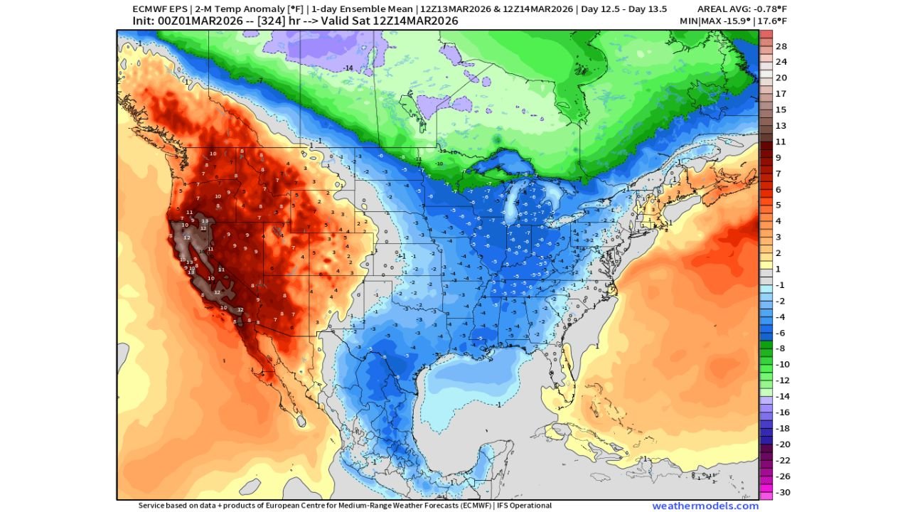
The latest European ensemble projection valid Saturday, March 14, 2026, shows a sharp temperature contrast setting up across the country — with widespread below-normal readings expanding from the Plains into the Midwest, Ohio Valley, and parts of the East.
Cold Anomalies Expanding Into the Heartland
The temperature anomaly map highlights deep blue shading across:
- The Dakotas
- Nebraska
- Kansas
- Missouri
- Iowa
- Illinois
- Indiana
- Ohio
- Kentucky
- Tennessee
- Arkansas
- Texas
- The Gulf Coast region
Much of this region is projected to run several degrees below normal for mid-March, with some areas in the Midwest showing anomalies approaching 5–10 degrees below average.
The cooling appears tied to a frontal system pushing through around the 14th, allowing colder air to settle southward.
Arkansas in the Cooler Zone
Arkansas sits squarely within the projected below-normal corridor.
While this does not signal an extreme Arctic outbreak, it does suggest a noticeable drop compared to early-March warmth — particularly if recent mild conditions have dominated.
For Waldron and surrounding areas, this could mean:
- A brief cool-down lasting a few days
- Below-average daytime highs
- Increased heating demand during the period
Western U.S. Remains Warm
In sharp contrast, the Western United States continues to show strong positive anomalies.
Deep red shading dominates:
- California
- Nevada
- Arizona
- Utah
- Oregon
- Washington
- Idaho
- Montana
- Portions of Colorado
Many western states are projected to remain well above normal, continuing the broader warm pattern that has characterized much of the winter season.
This east-west temperature split is one of the most defining features of the current forecast.
Short-Lived Cooldown Likely
While the trend toward colder data is notable, projections suggest this may be relatively short-lived.
The ensemble mean indicates a temporary dip rather than a prolonged cold regime. However, even a brief cold surge can create ripple effects in energy markets, as heating demand spikes during transitional seasons.
Forecasters had previously mentioned watching for a brief Gas-Weighted Heating Degree Day (GWHDD) spike around this timeframe — and this setup aligns with that potential.
Temperature Battle Line Near the Rockies
The map clearly shows the dividing line near the Rockies:
- West of the mountains: strong warmth persists
- East of the mountains: cooler air dominates
Such patterns often develop when the jet stream amplifies, allowing ridging in the West and troughing across the central and eastern states.
What to Watch Next
Key questions heading into mid-March:
- How long will the cooler air linger?
- Will precipitation accompany the frontal passage?
- Does the pattern reload with additional cold surges?
At this point, the signal supports a brief but noticeable cooldown centered around March 14.
For continued updates on shifting national temperature patterns and what they mean for Arkansas and the surrounding region, stay with WaldronNews.com for the latest forecast breakdowns and analysis.