
Midwest and East Coast From Illinois to New York Turn 10–20°C Above Normal by Feb. 17, While Montana and the Pacific Northwest Stay Much Colder
UNITED STATES — A dramatic temperature split is setting up across the country by mid-February, with new ECMWF model data showing much of the Midwest, Great Lakes, Ohio Valley, and Northeast surging well above normal — while the Northern Rockies and Pacific Northwest remain locked in significantly colder air.
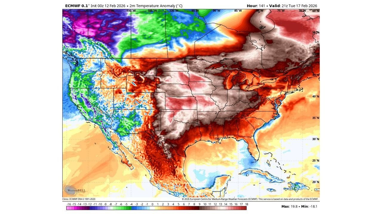
The latest ECMWF 2-meter temperature anomaly forecast valid 21Z Tuesday, February 17, 2026, highlights a sharp west-to-east contrast that could define the second half of the month.
Midwest and Great Lakes Warm Surge: Illinois, Michigan, Ohio, Pennsylvania Feel Early Spring Push
The anomaly map shows widespread deep red and brown shading stretching from:
- Illinois
- Indiana
- Michigan
- Ohio
- Pennsylvania
- New York
- New England
- Portions of Missouri and Kentucky
These areas are projected to run 10°C to nearly 20°C above average in some spots — an extraordinary departure for mid-February.
Cities like:
- Chicago
- Detroit
- Cleveland
- Pittsburgh
- New York City
- Boston
could experience temperatures that feel far more like late March or early April than the heart of winter.
Even parts of the Southeast, including Georgia, the Carolinas, and Virginia, show notable above-normal warmth, though not quite as extreme as the Great Lakes core.
This pattern strongly suggests that winter cold across much of the East will struggle to re-establish itself in the short term.
Texas and the Southern Plains Stay Warm
The anomaly map also shows widespread positive departures across:
- Texas
- Oklahoma
- Arkansas
- Louisiana
The Southern Plains appear firmly in the warm sector of the pattern, supporting the idea that sustained hard freeze threats are becoming less likely as we approach late February.
This warmth could also increase the potential for active weather setups if moisture and instability align.
Northern Rockies and Pacific Northwest: Montana, Idaho, Washington Stay Much Colder
In stark contrast, the coldest anomalies remain concentrated over:
- Montana
- Idaho
- Wyoming (northern portions)
- Eastern Washington
- Parts of Oregon
These regions show strong negative temperature anomalies, with some areas projected to run well below seasonal averages.
The purple and blue shading over Montana and surrounding areas indicates that winter is far from finished there. While the East warms dramatically, the Northern Rockies remain under colder air masses.
This sharp thermal boundary across the central U.S. will likely act as an active storm corridor.
Groundhog Said “Longer Winter” — But February Says Otherwise for the East
The commentary accompanying the model graphics notes that despite earlier signals suggesting a prolonged winter, recent trends are shortening the cold window across much of the eastern half of the country.
The ECMWF data strongly supports that idea:
- The coldest air is displaced west and north
- The core of winter retreats from the Midwest and East Coast
- Warm anomalies dominate the central and eastern CONUS
If this setup verifies, many eastern states could experience one of their warmest late-February stretches of the season.
What This Means Going Forward
- Snow chances decrease for major East Coast cities in the short term.
- Lake-effect potential drops as overall air masses moderate.
- Early spring-like days become increasingly common from Illinois to New York.
- The temperature gradient across the Plains may enhance storm development zones.
However, this does not eliminate winter entirely — pattern shifts can still occur into March.
Bottom Line for WaldronNews Readers
By February 17, the United States will be sharply divided:
- Warmth dominates from Texas through Illinois, Michigan, Ohio, Pennsylvania, and New York
- Much colder air remains over Montana, Idaho, Washington, and parts of Wyoming
For much of the Midwest and East Coast, winter may be running out of runway — at least temporarily.
Stay with WaldronNews.com for continued updates as model guidance evolves and we track whether this warm surge locks in or if winter makes one more push before March.