
Midwest Faces Dangerous –50 Wind Chills This Sunday as Arctic Blast Slams Into Minnesota and Surrounding States
MINNESOTA — Extreme Cold Expected as Wind Chills Plunge to Life-Threatening Levels, A brutally cold Arctic air mass is set to surge into the Midwest this weekend, delivering dangerously low wind chills that may fall as low as –50 degrees across parts of Minnesota, North Dakota, and surrounding states. New wind chill projections for Sunday morning show widespread areas of intense cold, with potentially life-threatening conditions developing before sunrise.
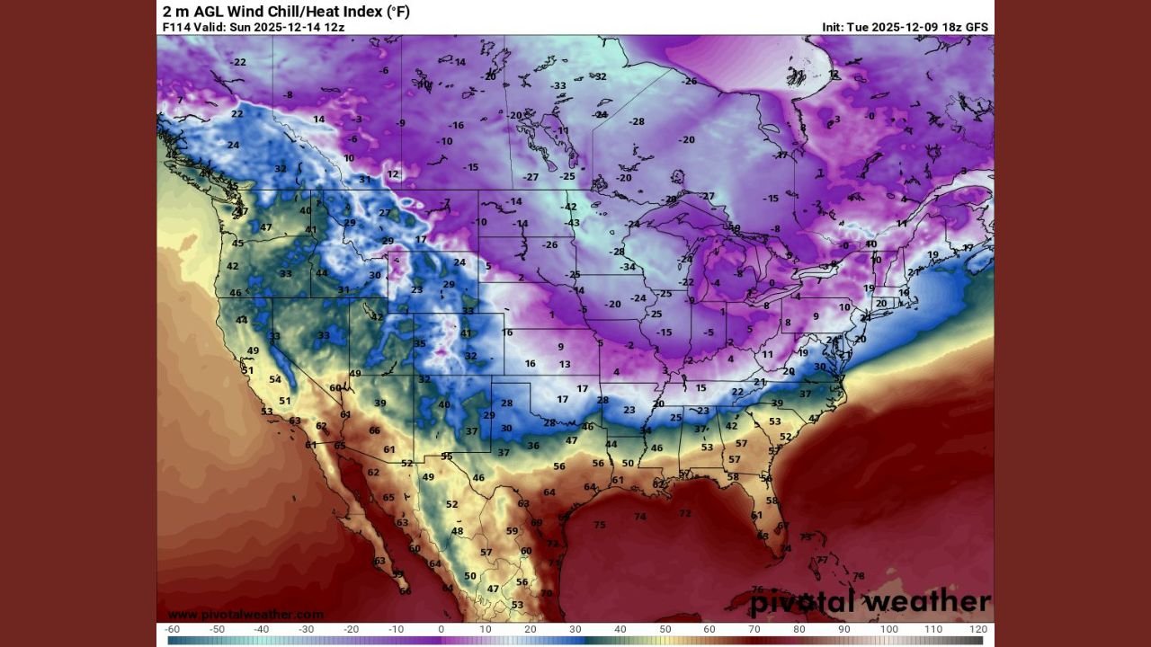
The latest analysis highlights a broad zone of purple and deep violet shading across the northern United States, reflecting the magnitude of the cold. Wind chills this low can cause frostbite in a matter of minutes, and prolonged exposure may become deadly.
This event marks one of the coldest outbreaks of the season so far, with the core of the Arctic air settling directly over the Upper Midwest.
A Closer Look at the Forecast Map
On Sunday morning, wind chill values across the region are expected to include:
- –40 to –50 degrees in northern and western Minnesota
- –30 to –40 degrees across much of North Dakota and northern Wisconsin
- –20 to –30 degrees stretching into Iowa, Illinois, and Michigan
- Single digits and teens as far south as Kentucky, Tennessee, and the Mid-Atlantic
The map illustrates a powerful dome of cold pressing southward, with the harshest values centered over Minnesota and the Dakotas where winds and temperatures will align for extreme conditions.
Even large Midwest cities — including Minneapolis, Fargo, Duluth, and Eau Claire — are expected to experience extremely dangerous cold.
Why Wind Chills Will Be So Severe
Several atmospheric factors are coming together to create a high-impact cold event:
- A deep Arctic air mass dropping south from Canada
- Strong winds on the backside of a departing storm system
- Clear skies allowing temperatures to plunge before dawn
- Snowpack in parts of the Midwest enhancing the level of surface cooling
When bitter temperatures combine with sustained winds, the wind chill — or “feels-like” temperature — drops quickly and sharply. This accelerates heat loss from exposed skin and increases the risk of hypothermia.
Travel, Outdoor Activity, and Safety Concerns
Because wind chills in the –40 to –50 range can begin causing frostbite on exposed skin in 5–10 minutes, residents across Minnesota and the Upper Midwest are urged to take extreme precautions:
- Limit outdoor activity as much as possible
- Cover all exposed skin when outside
- Wear insulated, windproof clothing layers
- Keep emergency supplies in vehicles
- Check on vulnerable neighbors or family members
The cold may also trigger stress on the power grid, mechanical failures in vehicles, and frozen pipes in poorly insulated homes.
How Long the Cold Will Last
Sunday morning will represent the peak of the extreme cold, but dangerous wind chills may continue into:
- Sunday afternoon, especially across northern Minnesota
- Monday morning, though slowly moderating
- Early next week, with temperatures gradually returning closer to seasonal levels
Wind chill advisories and warnings are likely to be issued across multiple states.
Residents Should Prepare Now
With dangerous cold only days away, Minnesota residents — and those across the broader Midwest — are encouraged to plan accordingly:
- Ensure homes are adequately heated
- Prepare vehicles for subzero starts
- Keep extra blankets, food, and water on hand
- Protect pets and livestock from exposure
This type of Arctic outbreak can strain infrastructure and create sudden hazards, making preparation essential.
Stay with WaldronNews.com for continuing coverage of this Arctic blast, along with forecast updates and safety warnings as conditions evolve.