
Midwest Faces Significant Severe Weather Tuesday as Record Breaking Instability and Supercell Conditions Target Kansas City, Chicago, Springfield and Kirksville With Giant Hail and Tornadoes Possible
KANSAS CITY, Missouri — A high-impact and potentially historic severe weather event is taking shape for Tuesday, April 14 across the Midwest, as an extraordinarily energetic atmosphere builds over a corridor stretching from Kansas City and Kirksville, Missouri through Springfield, Illinois, Chicago, and Davenport — delivering what could be some of the highest atmospheric instability values seen in years across this region, with significant large to very large hail as the primary threat and supercells capable of producing tornadoes a real and serious concern wherever storms develop in the warm sector.
The atmosphere on Tuesday is not just loaded — it is historically loaded. Surface-based instability values are screaming across the Missouri-Illinois corridor, and the combination of that energy with sufficient low-level wind shear creates an environment where any storm that fires in the warm sector will immediately have access to everything it needs to become dangerous and long-lived.
Cities and States in Tuesday’s Severe Weather Corridor
- Missouri: Kansas City, Kirksville, Columbia, Springfield, Maryville, and Iola sit inside the core of the highest instability and storm rotation values — this is the absolute bullseye of Tuesday’s threat
- Illinois: Kirksville corridor into Springfield, Chicago, Davenport, and Watseka are all within the dangerous warm sector where supercells are most likely to develop and sustain
- Iowa: Des Moines and Davenport fall within the severe weather corridor as the storm system pushes northeast
- Kansas: Iola and the northeast Kansas fringe sit on the western edge of the high-instability zone
- Indiana: Fort Wayne and surrounding communities sit within the broader severe weather threat area
- Wisconsin/Michigan: Milwaukee, Chicago metro extending into southern Wisconsin and western Michigan fall within the storm threat corridor as systems push northeast Tuesday evening
What the Atmosphere Is Showing for Tuesday
Three separate layers of atmospheric data are all telling the same alarming story for Tuesday afternoon and evening:
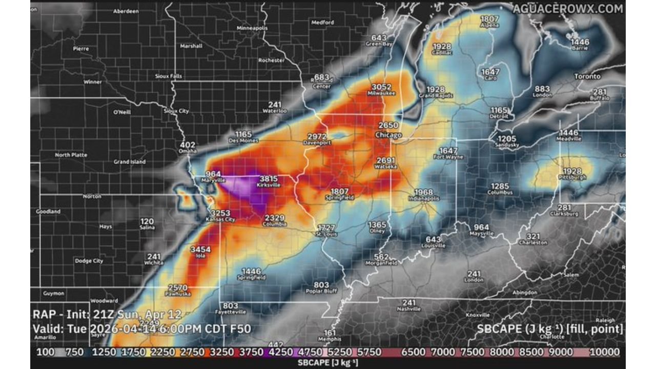
Explosive Instability — SBCAPE Values: The surface-based instability map valid Tuesday, April 14 at 6:00 PM CDT shows SBCAPE values — a direct measure of the energy available to fuel thunderstorms — reaching absolutely extraordinary levels across the Midwest. The Kansas City to Kirksville to Springfield corridor is showing values of 3,253 to 3,815 J/kg with the purple core near Kirksville indicating values pushing toward 4,250 J/kg and beyond. Further north into the Chicago, Milwaukee, and Davenport corridor, values of 2,650 to 3,052 J/kg confirm that the entire warm sector from Missouri to the Great Lakes is loaded with historic storm fuel. Values this high do not produce ordinary thunderstorms — they produce explosive, fast-developing, long-lived severe storms.
Jet Stream — 500mb Winds at 100+ Knots: The upper-level wind pattern for Tuesday shows a screaming jet stream with 500mb wind speeds reaching 100 to 140+ knots in a focused corridor directly over the severe weather threat area from Kansas City through Chicago and into the Great Lakes. This powerful upper-level flow provides the atmospheric forcing and wind shear that organizes storm systems, keeps them severe for extended periods, and allows supercells to maintain their rotation over long distances. When jet stream winds are this strong directly over an area with this level of surface instability, the setup is textbook severe weather outbreak territory.
Storm Rotation Potential — 3km EHI Values: The Energy Helicity Index map for Tuesday shows EHI values reaching 4 to 6 across a focused corridor centered on Kansas City, Maryville, Kirksville, and the Missouri-Illinois border region. EHI combines atmospheric instability and rotational potential into a single number — values above 1 are concerning, values above 2 are significant, and values reaching 4 to 6 are in the range associated with long-track, violent tornadoes. The purple cores of EHI near Kansas City and Kirksville are a direct and explicit signal that the atmosphere over this corridor on Tuesday afternoon is capable of supporting the most dangerous type of rotating thunderstorms.
Atmospheric Sounding — TOR Designation: The atmospheric profile for Tuesday evening near the Kansas City corridor shows a Psbl Haz. Type designation of TOR — tornado — confirming that the primary hazard classification for this environment is rotating storms producing tornadoes. The sounding reveals SBCAPE of 4,158 J/kg, a Significant Tornado Parameter (STP) of 0.99 — approaching the critical 1.0 threshold — and CAPE values of 449 at the surface with a relatively weak cap of just -12, meaning storms will fire without much resistance once the afternoon heating begins.
Why Kansas City and the Missouri-Illinois Corridor Are in the Most Danger
The convergence of the highest instability, the strongest storm rotation values, and the most favorable atmospheric profile all point to a single geographic bullseye for Tuesday’s most dangerous conditions — the Kansas City to Kirksville to Springfield, Illinois corridor.
This area sits in the warm sector — the region of the atmosphere where Gulf moisture, surface heating, and upper-level dynamics all combine most aggressively. Storms that develop here will not be struggling for energy or organization. They will immediately enter an environment providing over 3,800 J/kg of storm fuel, EHI values of 4 to 6, and jet stream support of 100+ knots overhead. A storm entering this environment is like throwing gasoline on an already burning fire.
The northward extent of the threat remains one of the key uncertainties heading into Tuesday — forecasters acknowledge there is still uncertainty about exactly how far north the warm sector and its associated severe weather potential will extend. But where storms do develop within the warm sector, the word being used is clear — they will be capable of producing significant hazards including very large hail, damaging winds, and tornadoes.
Multi-Day Context
Tuesday represents the fourth consecutive day of active severe weather across the central United States following Saturday’s Nebraska-Kansas tornado outbreak, Sunday’s Texas-Oklahoma conditional threat, and Monday’s Enhanced Risk across Minnesota and Wisconsin. The atmosphere has been cycling relentlessly through dangerous setups, and Tuesday closes out this extraordinary stretch with what the data suggests is the most energetically extreme environment of the entire sequence — concentrated directly over the Missouri and Illinois corridor.
After Tuesday, the pattern begins to show signs of transition — but not before this final and potentially most powerful round delivers its impact across the Midwest.
What Tuesday’s Threat Demands Right Now
- Residents across Kansas City, Kirksville, Columbia, Springfield, and Davenport are in the highest EHI and instability zone — treat Tuesday afternoon as an immediate danger period and have shelter identified before noon
- Very large hail is the most likely severe weather outcome Tuesday — every vehicle in the Missouri and Illinois severe weather corridor should be under cover before Tuesday afternoon
- The TOR atmospheric designation means tornado-producing supercells are the primary hazard type — not just wind or hail events — and shelter from tornadoes must be a real and practiced plan before Tuesday
- Watch for SPC watches to be issued Tuesday morning as storm initiation timing becomes clearer — act on watches immediately, do not wait for warnings
- The 6 PM CDT timing shown in the model data is when conditions will be most dangerous — afternoon and evening plans across Missouri and Illinois should be moved indoors well before this window
- Monitor NWS Kansas City and NWS Chicago offices for real-time warning issuance — lead times may be short given the speed of storm development in a high-CAPE environment
Tuesday is not a day to take lightly across Missouri, Illinois, and the broader Midwest. The atmosphere is loaded with historic levels of energy, storm rotation potential is extreme near Kansas City and Kirksville, and any storm that develops in the warm sector Tuesday afternoon will have immediate access to everything it needs to become violently severe.
WaldronNews.com will continue tracking Tuesday’s severe weather threat across Missouri, Illinois, Iowa, and the broader Midwest and will provide updates as watches, warnings, and storm reports become available throughout the day.