
Midwest, Great Lakes, and Northeast Brace for Temperature Whiplash as Brief Warm Surge Gives Way to Sharp Cold Blast
UNITED STATES — Forecast data shows a high-impact temperature swing developing across the central and eastern United States, with winter conditions briefly easing Tuesday and Wednesday before a strong cold blast rapidly returns by Thursday and Friday. The most affected regions based on the data are the Midwest, Great Lakes, and Northeast, where temperatures will fluctuate sharply over just a few days.
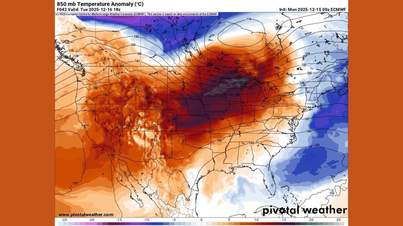
Upper-air temperature anomaly maps clearly illustrate this pattern: strong above-normal warmth briefly floods northward, followed closely by another push of much colder air plunging back into the same areas.
Brief Warm Surge Temporarily Pushes Winter Out
The first phase of this pattern is a short-lived warm surge that spreads across the most impacted regions early in the week.
Forecast guidance indicates:
- Temperatures rising well above recent averages
- A noticeable break from winter chill
- Partial melting of existing snow cover
As the forecast commentary notes:
“Winter will be leaving the building tomorrow as a surge of warm air takes over for Tuesday and Wednesday.”
This warmth is driven by a strong upper-level ridge, allowing milder air to expand northward before the pattern quickly reverses.
Why the Warm Spell Will Not Last
Despite the sudden moderation, atmospheric signals show no sustained shift away from winter. The same model data highlights a fast-moving transition, with the warm ridge quickly replaced by a deep trough.
This means:
- The warm air lacks staying power
- Cold air remains locked just to the north
- The overall winter pattern stays intact
As one forecast description put it:
“Don’t get too cozy — this is only a short break.”
Sharp Cold Blast Slams Back by Late Week
By Thursday and Friday, forecast models show a renewed and decisive return of cold air into the most affected regions.
Key impacts of the cold blast include:
- Rapid temperature drops following the warm spell
- Refreezing of melted snow and slush
- Reinforcement of winter conditions
850-mb temperature anomalies show below-normal air surging southward, confirming a quick snap back to winter.
As described in the forecast messaging:
“A sharp cold blast returns late week, bringing winter back.”
Travel and Safety Concerns During the Transition
The combination of melting followed by refreezing raises concerns for travel and daily activities.
Potential hazards include:
- Slick roads and sidewalks
- Black ice forming overnight
- Stress on infrastructure from rapid temperature changes
Residents in the most impacted areas should remain alert, as conditions can deteriorate quickly once colder air arrives.
What This Pattern Signals Going Forward
This temperature whiplash highlights a volatile winter pattern, where brief warm breaks are quickly replaced by renewed cold.
While the early-week warmth may feel spring-like, the late-week reversal reinforces that:
- Winter is not finished
- Additional cold intrusions remain possible
- Snow and ice threats can return quickly
As one observation summarized it:
“Mother Nature is just taking a short coffee break before throwing winter back into gear.”
WaldronNews.com will continue monitoring rapid temperature shifts and winter pattern changes across the country. If you experience significant warming followed by sudden cold in your area this week, share your local conditions with WaldronNews.com to help keep readers informed.