
Midwest, Great Lakes and Southern States Told to Watch Developing Summer Rain Pattern as New Forecast Signals Major Shift
UNITED STATES — A new seasonal outlook is pointing toward a significant shift in summer precipitation patterns, with multiple long-range models aligning on a wetter-than-normal trend across the Midwest, Great Lakes, and parts of the Southern United States.
Forecast signals from major seasonal models including ECMWF, CFS, and CANSIPS are showing consistent agreement, which increases confidence that this is not just a short-term fluctuation but a developing large-scale weather pattern heading into summer 2026.
Strong Signal for Wetter Pattern Across Midwest and Great Lakes
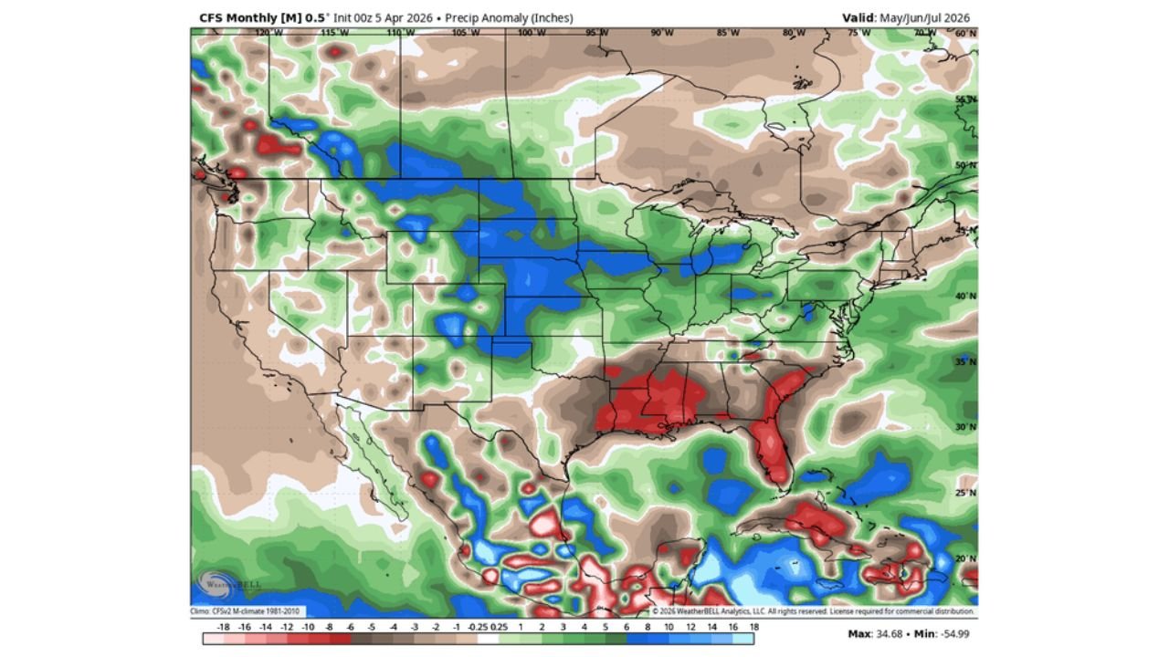
The most consistent and strongest signal appears across the Central Plains, Midwest, and Great Lakes region, where widespread above-average rainfall anomalies are being projected.
States including Iowa, Illinois, Wisconsin, Michigan, Indiana, and Ohio are showing repeated green shading across all major models, indicating a higher probability of frequent rain events and storm systems.
This pattern suggests:
- Repeated storm tracks moving west to east
- Increased thunderstorm frequency
- Higher chances of multi-day rainfall events
- Elevated localized flooding risk, especially in low-lying or saturated areas
Overall, this region is likely to experience a more active and moisture-rich summer pattern compared to normal, especially during June through early August.
Southern States Show Strong but Uneven Rainfall Signals
Across the Southern United States, the forecast becomes more regionally complex but still active.
The CFS model strongly highlights wetter-than-normal conditions across:
- Texas
- Louisiana
- Mississippi
- Alabama
- Georgia
- Florida
Some of these areas are even showing intense rainfall anomalies, particularly along the Gulf Coast and Southeast.
However, models like ECMWF and CANSIPS suggest a more patchy and uneven distribution, meaning:
- Some locations could see heavy rain and storm clusters
- Nearby regions could remain closer to normal or slightly dry
This creates a high-contrast summer setup, where storm corridors may repeatedly impact certain zones, while others miss out.
Early Season Storm Surge Expected in May and June
One of the most important takeaways is the likelihood of a storm-heavy start to summer.
Forecast data strongly supports:
- Enhanced moisture availability
- Increasing instability across the Plains and Midwest
- A more active jet stream pattern early in the season
This combination points toward:
- Frequent thunderstorm outbreaks in May and June
- Increased risk of severe storms
- Potential for heavy rainfall bursts and flash flooding events
This early-season activity could set the tone for a volatile start to summer across central and eastern U.S. regions.
Possible Disruption Later Due to Developing Climate Factors
Despite the strong early signal, there are indications that mid-to-late summer may not follow the same pattern consistently.
Some model guidance suggests a developing El Niño influence, which could:
- Shift storm tracks
- Reduce rainfall in some areas during July and August
- Create a split-season pattern, with wetter early summer and more variable late summer
This means the season may evolve into:
- Stormy May–June period
- Followed by uncertain or regionally shifting rainfall trends later
Key Regional Impacts to Watch
For the Midwest and Great Lakes, this pattern raises concerns about:
- Soil saturation and runoff issues
- Increased river and stream levels
- Possible agricultural impacts, both positive (moisture) and negative (flooding)
For the Southern U.S., impacts could include:
- Localized heavy rain zones
- Higher risk of slow-moving storm systems
- Potential coastal moisture surges from Gulf activity
Meanwhile, parts of the Northern Plains and Upper Midwest may see more balanced or slightly mixed conditions, depending on how storm tracks evolve.
Why This Forecast Is Gaining Attention
The key reason this outlook is important is the strong agreement between multiple independent seasonal models, which is relatively rare.
This alignment suggests:
- A larger atmospheric pattern is in place
- Increased confidence in a wetter-than-normal trend overall
- A higher likelihood of repeat storm setups rather than isolated events
While exact timing and locations will continue to refine, the big-picture signal is clear — summer 2026 is trending more active and wetter across key regions of the United States.
What Residents Should Do Now
With early indications pointing toward an active storm season, residents in impacted regions should:
- Stay alert for spring storm updates starting in May
- Monitor local flood-prone areas
- Prepare for periods of heavy rain and repeated storms
This is especially important in regions where multiple rounds of rainfall could occur within short timeframes, increasing flood potential.
Stay connected with WaldronNews.com as we continue tracking this developing summer weather pattern, bringing timely updates on storm risks, rainfall trends, and regional impacts across the United States.