
Midwest, Northeast and Ag Belt Communities Told to Watch Sudden Freeze Risk Before Storm Pattern Returns Later This Week
UNITED STATES — A sharp and impactful weather shift is developing across the Midwest, Northeast, and key agricultural regions, as new forecast data signals a widespread frost and freeze threat early in the week, followed quickly by a return of warmth and storm activity later in the week.
This rapid transition is creating a high-risk window for crops and early planting, especially across the Ag Belt and northern states, where temperatures are expected to drop well below normal.
Widespread Frost and Freeze Risk Expands Across Ag Belt and Northeast
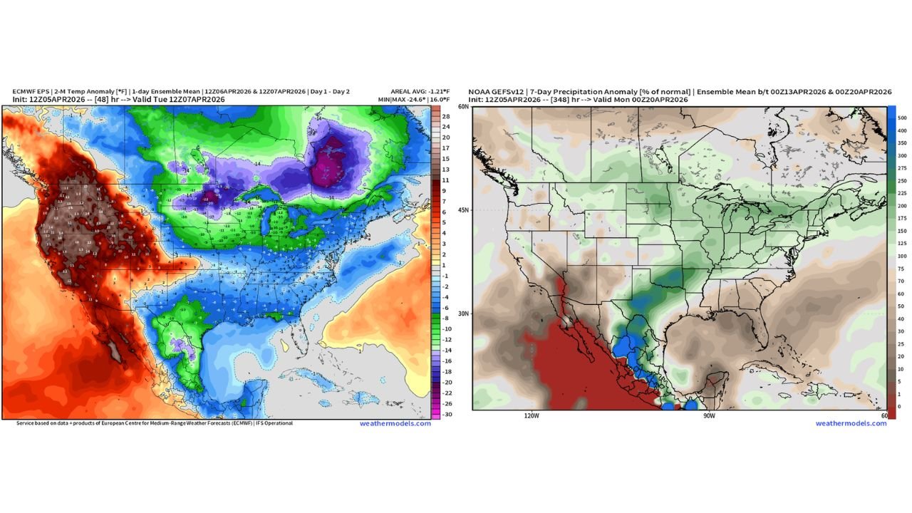
Forecast temperature anomaly data clearly shows a significant cold outbreak spreading across the central and eastern United States, with the most intense cold centered over:
- Iowa
- Illinois
- Indiana
- Ohio
- Michigan
- Pennsylvania
- New York
These areas are expected to experience below-normal temperatures ranging from 10°F to over 20°F colder than average, creating ideal conditions for:
- Widespread frost formation
- Potential hard freeze conditions in some locations
- Increased risk of crop damage and planting delays
The coldest air appears concentrated across the Upper Midwest and Great Lakes, where deeper purple shading indicates the strongest temperature departures.
Early Week Cold Could Impact Crops and Agriculture
This setup is particularly concerning because it arrives during a critical period for agriculture.
Key concerns include:
- Damage to early-planted crops
- Stress on emerging vegetation
- Risk to fruit trees and sensitive plants
With little margin for error during spring planting season, even a short-lived freeze event can have long-lasting impacts on yield and crop health.
Rainfall Pattern Shows Limited Activity in the South but Storm Corridor Developing
At the same time, precipitation anomaly data highlights a split pattern across the country.
Areas expecting above-normal precipitation include:
- Parts of the Central Plains
- Sections of the Midwest
- Portions of the Mississippi Valley
Meanwhile, much of the Deep South and Southeast, including:
- Alabama
- Georgia
- Florida
- Mississippi
are expected to see below-normal rainfall, continuing a trend of drier conditions in the southern region.
This contrast suggests a developing storm corridor focused more toward central U.S. regions, while the South remains relatively dry.
Rapid Warm-Up and Storm Return Expected After Thursday
One of the most critical aspects of this forecast is the quick transition from cold to warm conditions.
By late week, especially after Thursday, models show:
- A return to above-normal temperatures
- Increasing moisture availability
- Development of storm systems across the central and eastern U.S.
This shift could lead to:
- Thunderstorm development across the Plains and Midwest
- Expanding rain coverage into the Northeast
- A more active late-week weather pattern overall
No Extended Planting Break Expected Through April 20
Despite the early-week cold, the broader pattern suggests there will be little to no extended planting delays through April 20, as warmer conditions return quickly.
However, the timing of the freeze followed by rapid warming creates a volatile setup, where:
- Crops exposed to freeze may struggle during rapid temperature swings
- Soil conditions could change quickly with incoming storms
- Farmers may need to adjust planting strategies carefully
Key Regions to Watch Closely
The most critical areas to monitor over the next several days include:
- Midwest (Iowa, Illinois, Indiana, Ohio, Michigan) for freeze risk and later storms
- Northeast (Pennsylvania, New York) for cold impacts and returning rainfall
- Central Plains for developing storm activity
- Southern States for continued dry conditions and limited rainfall
Why This Pattern Matters Right Now
This forecast highlights a high-impact weather swing within just a few days, combining:
- Cold extremes early in the week
- Rapid transition to warm and stormy conditions
- A split precipitation pattern across the country
Such rapid changes can amplify risks, especially in agriculture, where timing and stability are critical.
What Residents and Farmers Should Do
Residents and agricultural communities should take immediate steps to prepare for:
- Protecting sensitive plants and crops from frost
- Monitoring overnight temperature drops
- Preparing for storm activity later in the week
The next few days will be crucial in determining how this freeze-to-storm transition impacts the region.
Stay with WaldronNews.com for continuous updates as this rapidly evolving weather pattern develops across the Midwest, Northeast, and surrounding regions.