
Midwest Severe Weather Alert Expands From Missouri And Iowa Border Down To Red River Valley With Damaging Winds And Tornado Risk Today
MISSOURI — A broad and intensifying severe weather setup is now unfolding across the central United States, with a Level 3 Enhanced Risk centered near the Missouri–Iowa border and a wider Level 2 Slight Risk stretching south toward Oklahoma and North Texas, including the Red River Valley.
This setup signals a multi-state severe weather event today, with the potential for damaging winds, scattered hail, and a few tornadoes, especially in the higher-risk corridor.
Enhanced Risk Focused Near Missouri–Iowa Border
The most concerning zone today is across:
- Northern Missouri
- Southern to central Iowa
- Portions of western Illinois
This is where a Level 3 out of 5 Enhanced Risk has been issued, indicating:
- Increased storm organization
- Higher chances of severe weather reports
- Potential for clusters of strong storms
Cities in or near this zone include:
- Des Moines, IA
- Kirksville, MO
- Quincy, IL
Slight Risk Extends Deep Into Southern Plains
Surrounding the enhanced zone is a much broader Level 2 Slight Risk, covering:
- Kansas
- Oklahoma
- North Texas (including Dallas–Fort Worth and Red River Valley)
- Extending northeast into parts of Illinois and Indiana
This means severe storms will not be isolated to one area — instead, a long corridor of storms is expected from the Southern Plains into the Midwest.
Damaging Winds Are The Main Concern
Across the entire risk area, the primary hazard will be:
- Damaging wind gusts capable of reaching 60–70 mph
These winds could lead to:
- Downed trees
- Power outages
- Structural damage in stronger storms
Tornado Risk Exists — Especially In Midwest Corridor
While wind is the main threat, the environment also supports:
- A few tornadoes, particularly across Missouri, Iowa, and western Illinois
- The potential for isolated tornadoes farther south into Oklahoma
The tornado threat is expected to remain secondary but still important, especially where storms can briefly organize.
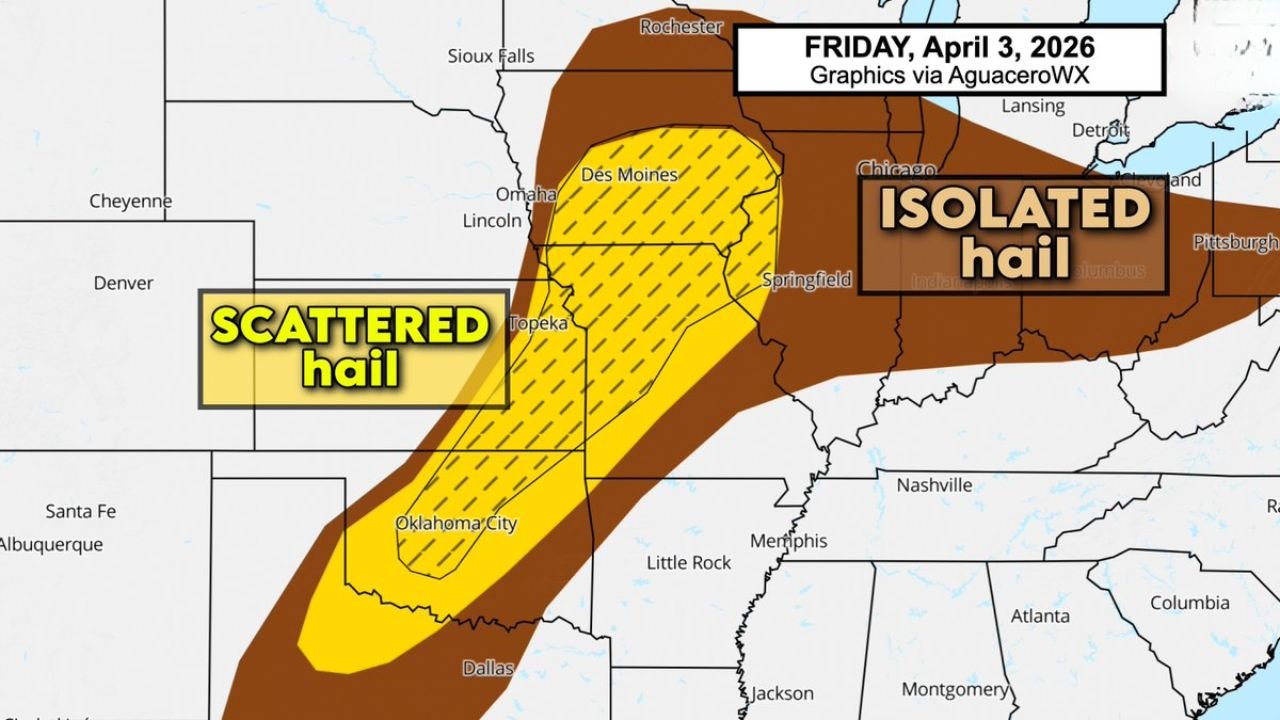
Hail Threat Spreads Across Multiple States
Hail is another concern with this setup:
- Scattered hail possible from Oklahoma into Iowa
- Isolated hail reports extending east into Illinois and Indiana
Some storms could produce larger hailstones, especially in areas where updrafts strengthen quickly.
Storm Coverage Will Be Widespread
Unlike isolated severe setups, today’s pattern suggests:
- Multiple clusters and lines of storms
- Activity spreading across several states simultaneously
- Periods of both organized and disorganized storm modes
This increases the likelihood that many areas will see at least some storm activity, even if not all locations experience severe conditions.
Timing Will Vary By Location
- Southern Plains (OK/TX): Storms begin earlier in the afternoon
- Missouri/Iowa/Illinois: Peak severe window later afternoon into evening
- Further east: Storms track in during the evening and overnight
A Broad, Multi-State Severe Setup Demands Attention
This is not a localized event — it is a large-scale severe weather pattern affecting a major portion of the central U.S., with overlapping risks across multiple regions.
Even outside the highest risk zone, any storm could briefly turn severe, especially along boundaries where conditions become more favorable.
Stay Alert As Storms Develop Rapidly
With multiple hazards possible and storms expected to evolve quickly:
- Monitor real-time updates
- Be ready to act on warnings
- Stay indoors during severe conditions
Stay with WaldronNews.com for continuous severe weather updates, live tracking, and alerts as this widespread storm system develops across Missouri, Iowa, Illinois, Oklahoma, and Texas throughout the day.