
Minnesota and Wisconsin Set for Clear, Chilly Night Before Temperatures Climb Into the 60s by Wednesday
TWIN CITIES, MN — A cool and mostly clear night is settling across Minnesota and western Wisconsin, but a noticeable warming trend will take hold through midweek, with highs climbing from the 40s and 50s Monday to the mid-50s and even mid-60s by Wednesday.
The latest forecast update issued Sunday afternoon highlights a steady rebound in temperatures after tonight’s chilly conditions.
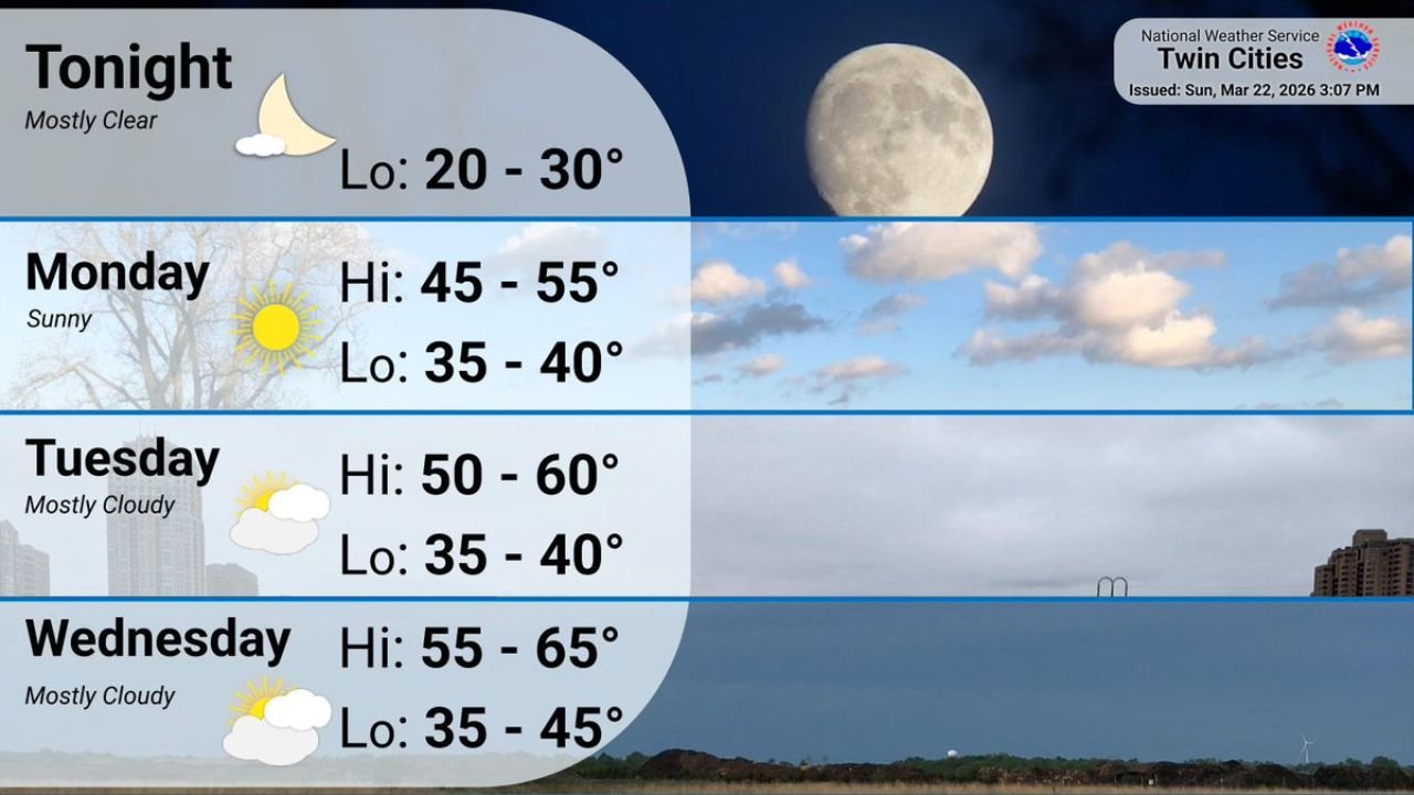
Tonight: Clear Skies and Cold Lows
Skies will remain mostly clear overnight across the Twin Cities and surrounding areas, allowing temperatures to fall quickly after sunset.
- Overnight lows: 20° to 30°
Residents should prepare for a cold start Monday morning, especially in outlying and rural communities where temperatures may dip toward the lower end of that range.
Monday: Sunshine Returns, Still Cool
Monday brings sunshine and improving daytime temperatures, though it will still feel cool compared to midweek levels.
- Highs: 45° to 55°
- Lows Monday night: 35° to 40°
With clear skies and lighter winds, conditions will feel much calmer compared to recent unsettled weather.
Tuesday: Gradual Warm-Up Continues
Cloud cover increases slightly Tuesday, but temperatures continue trending upward across both Minnesota and western Wisconsin.
- Highs: 50° to 60°
- Lows: 35° to 40°
Most locations should reach the lower 50s to near 60 degrees, depending on cloud coverage.
Wednesday: Peak of the Warm-Up
By Wednesday, the warming trend reaches its peak for the week. Despite mostly cloudy skies, much milder air moves into the region.
- Highs: 55° to 65°
- Lows: 35° to 45°
Many communities in southern Minnesota and western Wisconsin could see afternoon temperatures well into the 60s — a significant improvement from Sunday night’s freeze.
What This Means for the Region
The pattern shift signals a transition away from colder early-spring air toward more seasonable conditions. After a frosty start Monday morning, each day will feel progressively milder through midweek.
Residents should:
- Dress in layers Monday morning due to chilly lows
- Expect comfortable afternoon conditions by Tuesday
- Prepare for springlike temperatures Wednesday
The stretch of dry, moderating weather provides a favorable window for outdoor plans across Minnesota and Wisconsin before the next potential weather system develops later in the week.
Stay with WaldronNews.com for continuing updates on temperature trends and any changes to the midweek forecast.