
Minnesota Braces for Major Mid-December Pattern Shift as Deep Arctic Cold Targets Upper Midwest
MINNESOTA — Weather models are signaling a significant shift in the national pattern by mid to late December, pointing toward a deep intrusion of Arctic air across the Upper Midwest and a notable temperature divide across the United States. Meteorologists say Minnesota will be positioned directly in the path of the coldest air, with the state likely becoming the center of the strongest temperature anomalies in the country.
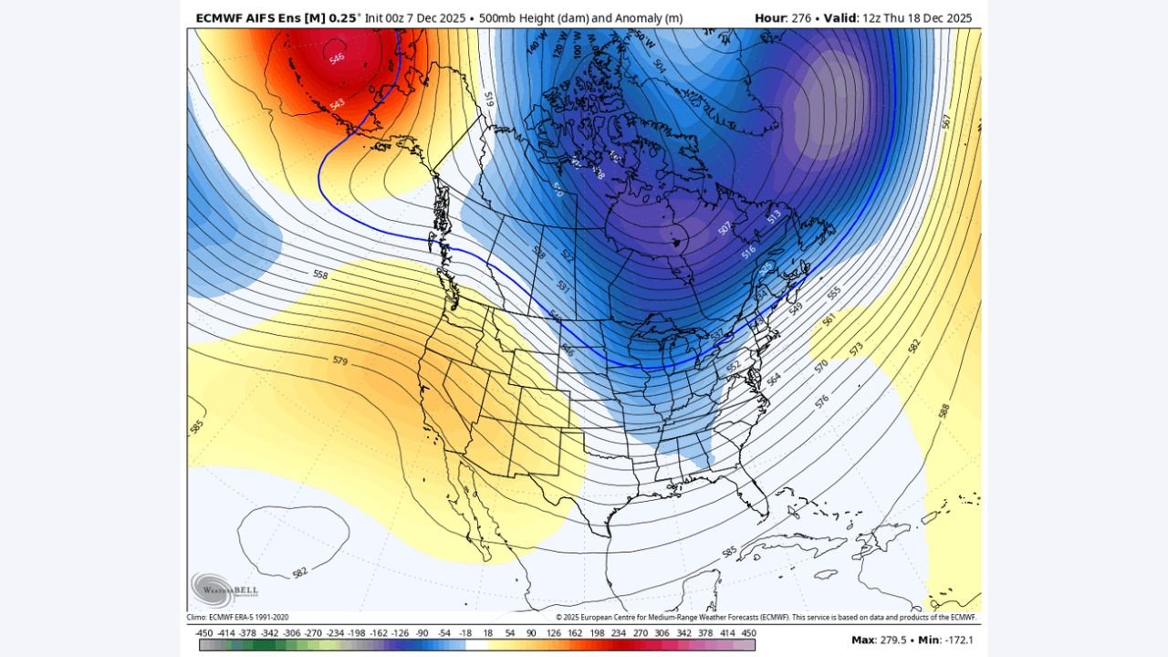
A Strong Trough Over Canada Will Drive Cold Directly Into Minnesota
Forecast charts show a powerful upper-level trough anchored over central and eastern Canada, with tightly packed height lines plunging southward into the northern United States. This setup funnels bitterly cold air straight into Minnesota, creating a sharp contrast with unseasonably warm conditions developing across the western states.
Model graphics reveal widespread areas of 10–20°F below-normal temperatures across the Upper Midwest, the most intense cold anomalies being centered directly over Minnesota. By December 18–19, the core of Arctic air is projected to extend from North Dakota across Minnesota into Wisconsin, reinforcing a prolonged stretch of freezing conditions.
Pacific Warmth and Western Ridge Add to Temperature Divide
While Minnesota faces a deep freeze, the western United States is poised to experience an entirely different pattern. A robust ridge and enhanced Pacific flow will promote warmer-than-normal temperatures across states such as California, Nevada, and Arizona, setting up a coast-to-coast thermal contrast.
Meteorologists note this is not a “torch” pattern, but it represents a meaningful warm-up for the West while Minnesota and neighboring regions deal with a reinforced Arctic blast.
Why the Shift Matters for Minnesota Residents
This mid-December pattern change has several implications:
- Wind chills may reach dangerous levels, especially during overnight hours.
- Snowpack preservation is likely, as below-freezing temperatures dominate Minnesota.
- Energy demand will rise, increasing heating needs statewide.
- Travel conditions could worsen if additional storm systems interact with the entrenched cold air.
Experts emphasize that while temperatures will be extreme, this pattern does not currently indicate a historic outbreak—however, it will be a substantial and prolonged cold period for Minnesota.
Looking Ahead
Meteorologists anticipate this colder regime to continue through late December before models suggest a gradual easing. Still, the pattern may reset again depending on upstream Pacific and Arctic influences.
Residents across Minnesota should monitor updated forecasts closely, as additional winter weather systems could form along the boundary separating the Western warmth from the Upper Midwest cold dome.
Stay alert to evolving weather conditions. For more updates like this, visit WaldronNews.com — your source for local weather, community alerts, and breaking regional reports.