
Minnesota, North Dakota, Iowa and Wisconsin Bracing for Dangerous –30°F Wind Chills as Arctic Blast Targets the Upper Midwest
MINNEAPOLIS, MINNESOTA – A surge of arctic air will drive dangerously low wind chills across the Northern Plains and Upper Midwest on Sunday morning, with widespread “feels-like” temperatures near –20°F and some locations tumbling into the –30s. The brutal cold will be reinforced by fresh snow on the ground, setting up one of the harshest mornings of this early winter stretch for millions of residents from North Dakota and Minnesota into Iowa, Wisconsin and northern Illinois.
How cold will it get and when?
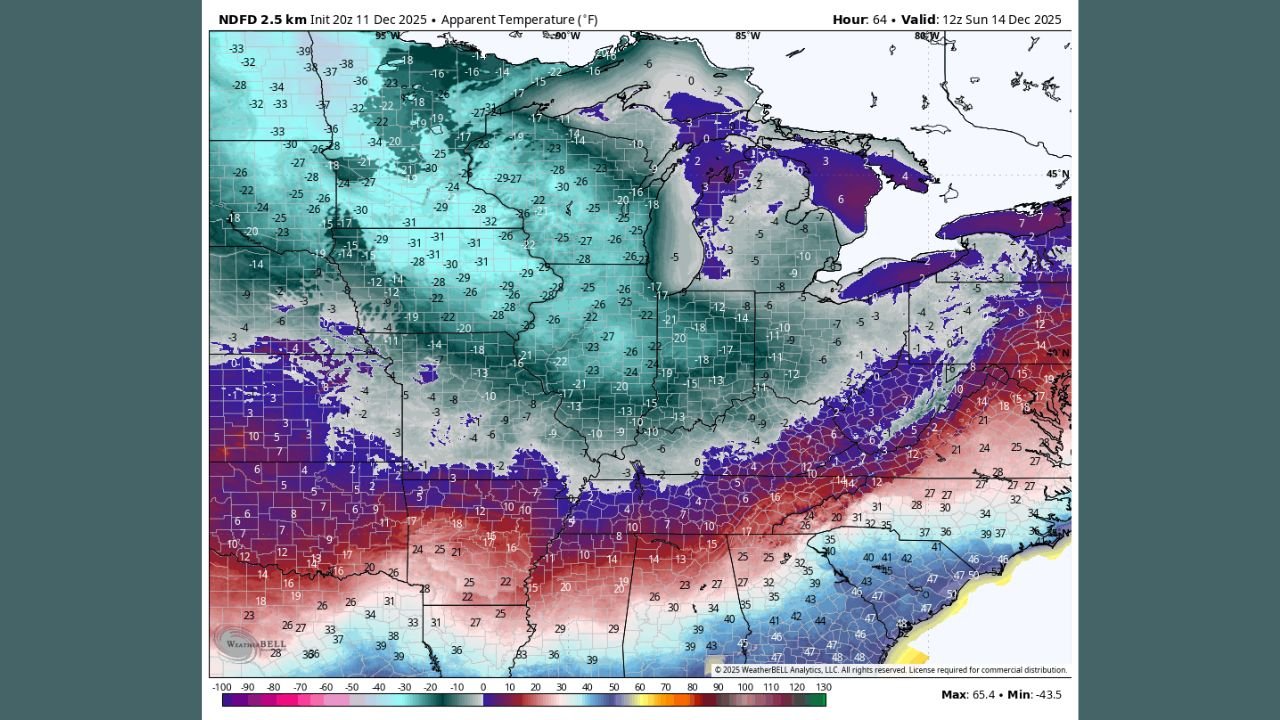
Forecast data from the National Digital Forecast Database for Sunday morning, December 14, shows apparent temperatures (wind chill values) plunging well below zero over a broad area.
- Large portions of North Dakota, northern South Dakota and central Minnesota are projected to see wind chills in the –25°F to –35°F range.
- Northern Wisconsin and the Upper Peninsula of Michigan are expected to fall into the –10°F to –25°F range.
- Farther south into Iowa, northern Illinois, northern Indiana and Ohio, wind chills will still be bitter, generally 0°F to –15°F by daybreak.
The worst of the cold will peak around and just after sunrise Sunday, when winds remain brisk while temperatures are at their lowest. Conditions will improve slightly during the afternoon, but many locations will still feel like the single digits or below zero.
Snowpack and clippers are making it worse
Meteorologists note that this round of bitter wind chills is “enhanced by the snow pack from this week’s clipper systems.” Fresh, powdery snow across the Upper Midwest allows heat to escape rapidly from the surface at night and reflects daytime sunshine, keeping actual air temperatures lower.
As strong northwest winds sweep across that cold surface, the result is a much colder wind chill than the thermometer alone would suggest. That combination will make it feel far more dangerous to be outside for long periods, especially in open rural areas.
Cold Weather Advisories and who is at greatest risk
Cold Weather and Wind Chill Advisories are already in effect across parts of the Northern Plains, and forecasters expect those alerts to expand into more of Minnesota, Iowa, Wisconsin and neighboring states as the weekend approaches.
The biggest concerns include:
- Frostbite in as little as 15–30 minutes on exposed skin where wind chills drop below –25°F.
- Hypothermia risk for anyone stranded or without adequate heating, especially the elderly, young children and people experiencing homelessness.
- Added stress on livestock and pets, which can suffer quickly in subzero wind chills without shelter.
Officials are urging residents to check on neighbors, ensure furnaces and space heaters are working safely, and make sure outdoor animals have insulated, dry shelter and fresh (unfrozen) water.
How long will the deep freeze last?
The worst wind chills are expected Sunday morning, but bitter air will linger into early next week across the Upper Midwest. Highs will struggle to escape the teens and low 20s for many locations on Sunday and Monday, with nighttime lows dropping back below zero in the coldest areas.
By mid-week, forecast guidance suggests a gradual moderation, but temperatures are still likely to run below normal for several days, especially from Minnesota and Wisconsin east into Michigan.
Staying safe in dangerous wind chills
Residents across Minnesota, North Dakota, South Dakota, Iowa, Wisconsin, northern Illinois and Michigan should prepare for a dangerously cold Sunday morning by:
- Limiting time outdoors and wearing multiple layers, including hats, scarves and insulated gloves.
- Covering all exposed skin to reduce frostbite risk.
- Keeping an emergency kit in vehicles with blankets, extra clothing, food and water in case of breakdowns.
- Bringing pets indoors and checking on vulnerable relatives or neighbors who may not have reliable heat.
As this arctic blast settles in, WaldronNews.com will continue to track updated wind chill forecasts, new advisories and any school or travel impacts across the Midwest. Stay tuned to our continuing coverage so you can plan ahead and stay safe during this dangerous stretch of winter weather.