
Minnesota, Wisconsin, Iowa, South Dakota, and Northern Illinois Brace for Major Weekend Winter Storm as High Travel Impacts Emerge From Minneapolis to Milwaukee
MINNEAPOLIS — Confidence is increasing that a significant winter storm will take shape during the second half of the weekend, with travel impacts expected to intensify beginning Saturday night and continuing through Sunday across portions of the Upper Midwest.
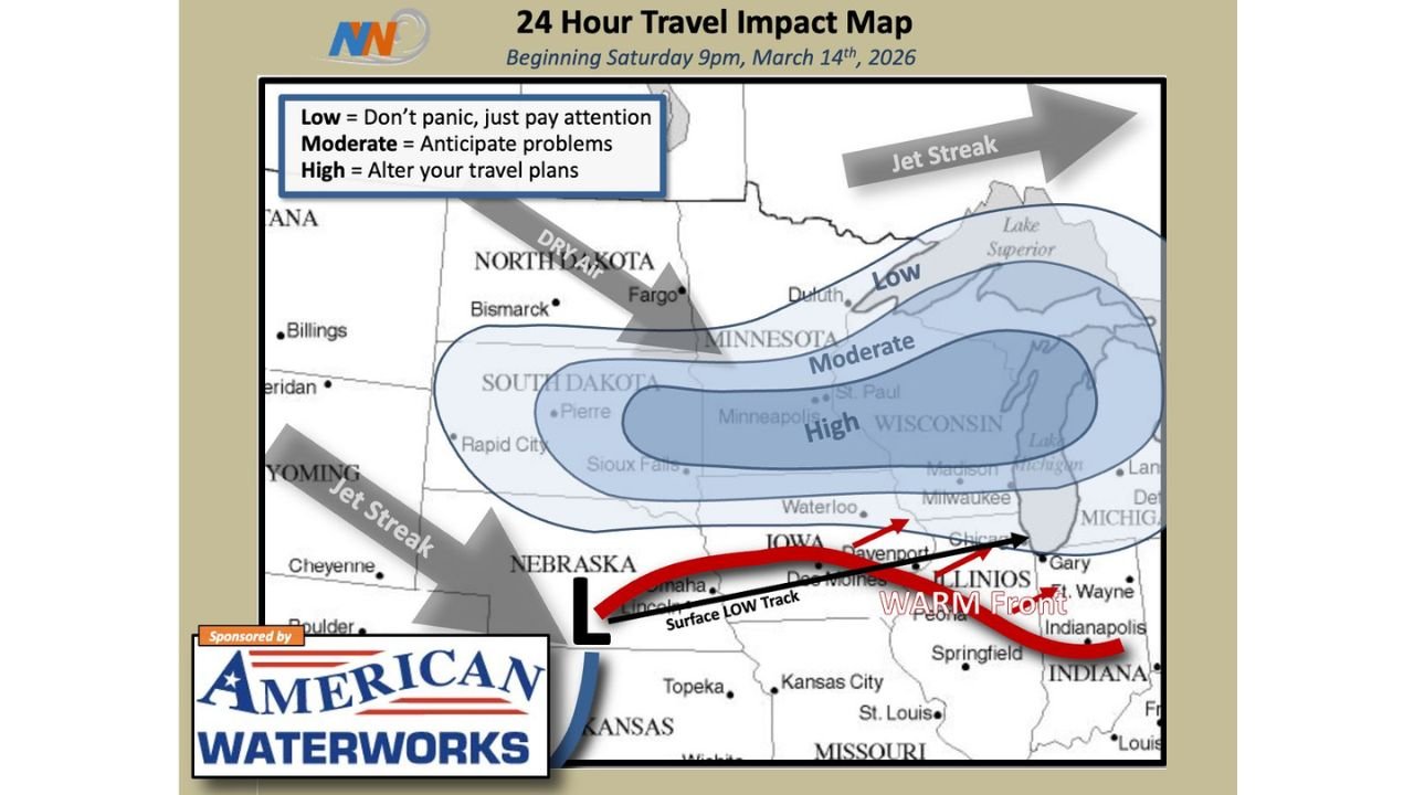
The latest 24-hour Travel Impact Map, beginning Saturday at 9 p.m. March 14, highlights a developing storm system tracking from Nebraska into Iowa and toward the Great Lakes — placing a corridor from South Dakota through Minnesota and into Wisconsin in the highest impact zone.
High Travel Impacts From South Dakota to Wisconsin
The map outlines three impact levels:
- Low – Pay attention
- Moderate – Anticipate problems
- High – Alter travel plans
The High impact zone stretches across:
- Eastern South Dakota, including areas near Sioux Falls
- Southern and central Minnesota, including Minneapolis and St. Paul
- Western and central Wisconsin, including areas near Eau Claire and Madison
This corridor suggests heavy snowfall rates and deteriorating road conditions are likely during the peak of the storm.
Moderate Impacts Extend Into Iowa and Northern Wisconsin
A broader Moderate impact area covers:
- Much of southern Minnesota
- Northern Iowa, including near Waterloo
- Western Wisconsin
This zone indicates widespread snow and potentially slick highways, especially along major travel routes such as Interstate 35 and Interstate 94.
Storm Track and Setup
The projected surface low is expected to track from Nebraska into Iowa, lifting northeast toward Wisconsin. A warm front arcs eastward across Illinois and Indiana, keeping southern areas warmer while colder air remains entrenched farther north.
Meanwhile, jet stream dynamics positioned over the northern Plains and Great Lakes are expected to enhance lift over Minnesota and Wisconsin — increasing the likelihood of heavier snowfall within the High impact corridor.
Dry air over North Dakota may limit snowfall totals there, keeping impacts lower compared to areas farther south and east.
Travel Concerns and Timing
Impacts are expected to ramp up beginning Saturday night and continue into Sunday, with the most significant issues likely during the overnight and early morning hours.
Travelers across:
- Minneapolis–St. Paul
- Southern Minnesota
- Western and central Wisconsin
- Eastern South Dakota
should anticipate snow-covered roads, reduced visibility, and slower travel times.
Planning Ahead
With forecast confidence increasing and model guidance aligning more consistently, officials advise reviewing travel plans now — especially for weekend road trips or commercial transport.
Areas in the High impact zone may need to consider delaying or adjusting travel if snowfall rates intensify as projected.
Stay with WaldronNews.com for continuing updates as this weekend winter storm develops across Minnesota, Wisconsin, Iowa, South Dakota, and northern Illinois.