
Mississippi, Alabama, Tennessee and Kentucky Told to Watch Severe Storm Patterns as New Data Shows Forecast Accuracy and Repeat Risk
UNITED STATES — Communities across the Lower Mississippi Valley, Tennessee Valley, and Ohio Valley are being urged to pay close attention to developing severe weather patterns, as new analysis highlights how a recent major storm event closely matched forecasts — raising concern for similar future setups.
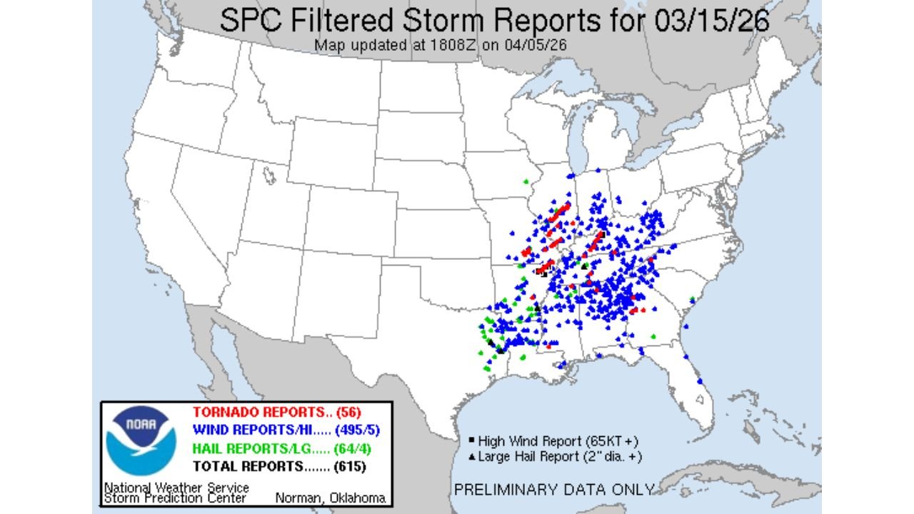
Newly reviewed data from a March 15 severe weather event shows that forecast models and outlooks were highly accurate, with storm reports aligning closely with predicted risk zones.
Storm Reports Confirm Widespread Severe Impacts Across Multiple States
Storm report data from the event shows hundreds of severe weather incidents across a broad region, including:
- Mississippi
- Alabama
- Tennessee
- Kentucky
- Parts of Indiana and Ohio
Confirmed reports included:
- 56 tornado reports
- Nearly 500 damaging wind reports
- Dozens of large hail events
These reports were heavily concentrated within the core risk zone identified before the event, showing how impactful the system became.
Forecast Risk Areas Closely Matched Actual Storm Activity
One of the most important takeaways is how closely the Storm Prediction Center outlook matched the final storm reports.
The forecast had outlined:
- A Level 3 Enhanced Risk across the central South
- A broad tornado probability zone across Mississippi, Alabama, and Tennessee
- A significant wind damage corridor extending into Kentucky and the Ohio Valley
When comparing forecast maps to actual reports:
- The highest concentration of tornado and wind reports aligned directly within the enhanced risk zone
- The core impact area matched the predicted storm track almost exactly
This level of accuracy highlights how reliable pattern recognition has become for large-scale severe events.
Tornado and Wind Threats Were the Primary Hazards
The event was driven by a setup that strongly favored:
- Widespread damaging straight-line winds
- Embedded tornadoes within storm lines
- Large areas of organized severe weather rather than isolated storms
Wind outlooks showed:
- A large 30%+ wind probability area
- A core zone with higher-end wind risk potential
Tornado outlooks included:
- A broad 5% to 10% probability zone
- Higher localized risk embedded within the main corridor
This combination led to both widespread damage and localized tornado impacts.
Why This Matters for Upcoming Weather Patterns
This analysis is important because it demonstrates how specific atmospheric setups can reliably produce similar outcomes when they repeat.
Key ingredients present during the event included:
- A strong warm sector feeding moisture northward
- Enhanced wind shear across multiple levels
- A large-scale storm system organizing into a line
When these factors come together again, they can produce:
- Large-scale severe weather outbreaks
- Fast-moving storm systems affecting multiple states simultaneously
Key Regions That Should Stay Alert Moving Forward
Based on both past impact zones and pattern recognition, the most vulnerable areas include:
- Mississippi and Alabama
- Tennessee Valley including Nashville region
- Kentucky and southern Indiana
- Parts of the Ohio Valley
These regions sit within a frequent storm corridor, where severe weather setups tend to track northeast.
What This Means for Residents
Residents in these areas should understand that:
- Severe weather events can develop quickly and impact large regions
- Forecasts are increasingly able to identify high-risk zones days in advance
- When similar patterns appear again, the risk of repeat impacts increases significantly
Preparedness becomes critical, especially during periods when:
- Storm systems organize into lines
- Wind and tornado threats occur simultaneously
- Impacts spread across multiple states within hours
Why This Forecast Alignment Is a Warning Signal
The strong alignment between forecast outlooks and actual storm reports is not just a success story — it also serves as a clear warning signal.
It shows that:
- When the atmosphere sets up in a certain way, outcomes can be highly predictable
- Future events with similar patterns may produce comparable impacts
This means upcoming forecasts showing similar setups should be taken very seriously.
What Residents Should Do Next
Communities across the Lower Mississippi Valley and Ohio Valley should:
- Stay alert for future severe weather outlooks
- Monitor SPC risk levels and updates
- Ensure access to real-time warnings and alerts
Being prepared ahead of time is essential, as these types of systems can move quickly and intensify rapidly.
Stay with WaldronNews.com for continued updates as forecasters monitor whether similar severe weather patterns could develop again across Mississippi, Alabama, Tennessee, and Kentucky in the coming weeks.