
Missouri and Illinois Brace for Sunday Severe Storm Threat as Enhanced Risk Targets Areas South of I-44 Including St. Louis, Cape Girardeau and Carbondale
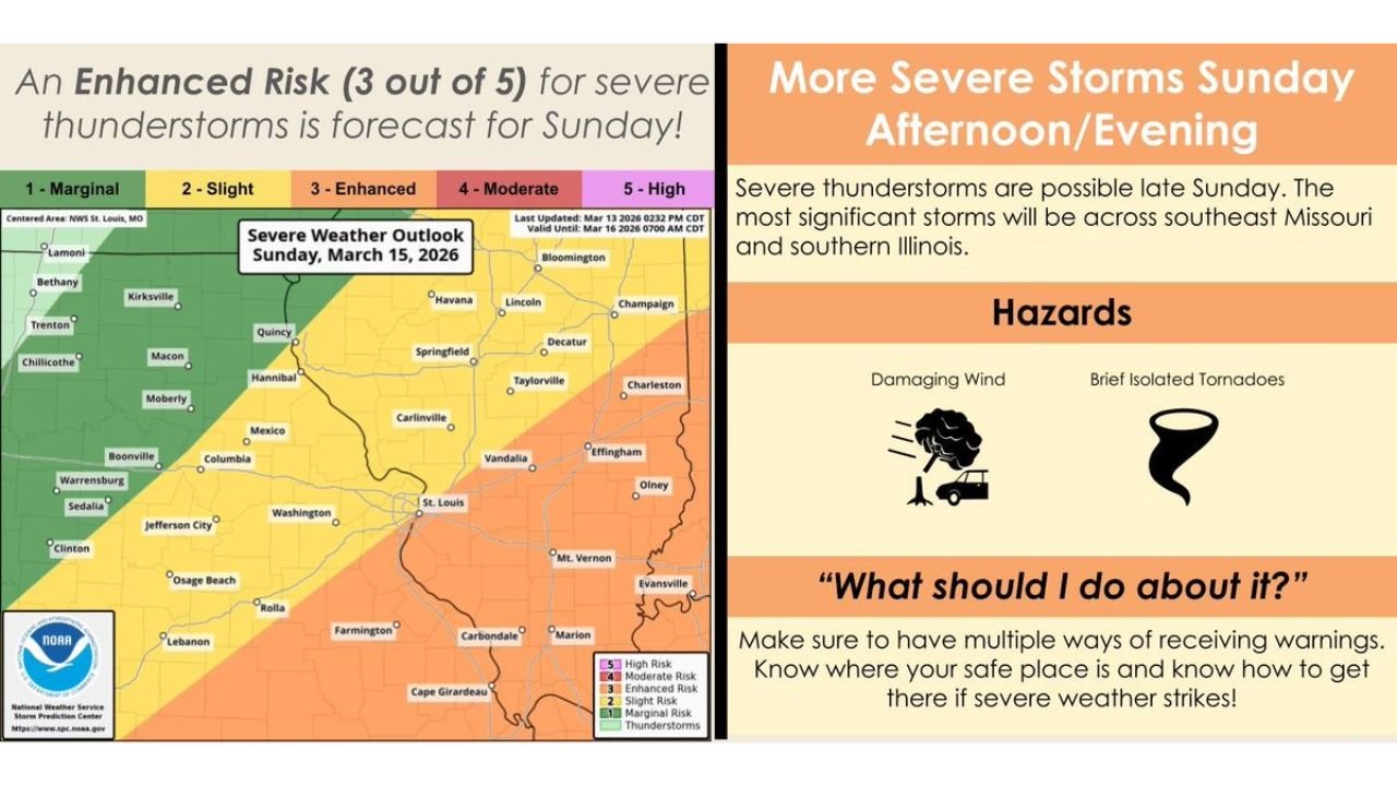
MISSOURI — A developing severe weather setup is expected to bring strong thunderstorms across Missouri and Illinois Sunday afternoon and evening, with forecasters warning that parts of the region face an Enhanced Risk (Level 3 of 5) for severe weather.
Meteorologists say the most significant storms are likely to develop along and south of the Interstate-44 corridor, where atmospheric conditions will favor stronger thunderstorm development as a powerful cold front moves through the Midwest.
The system could bring damaging winds and brief isolated tornadoes, particularly across southeast Missouri and southern Illinois.
Enhanced Risk Zone Includes Southeast Missouri and Southern Illinois
The latest severe weather outlook shows the highest storm risk concentrated across southeastern Missouri and southern Illinois, where unstable air and strong wind dynamics are expected to overlap Sunday afternoon and evening.
Cities and communities within or near the enhanced risk area include:
- Cape Girardeau, Missouri
- Farmington, Missouri
- Carbondale, Illinois
- Marion, Illinois
- Mount Vernon, Illinois
- Effingham, Illinois
- Vandalia, Illinois
These areas could experience the most organized severe storms, especially later in the day as the cold front approaches.
St. Louis Region Under Slight Risk
The St. Louis metropolitan area, along with parts of central Missouri and central Illinois, is currently within a Slight Risk (Level 2 of 5) zone.
Cities including:
- St. Louis
- Columbia
- Jefferson City
- Springfield, Illinois
- Quincy
may still experience strong thunderstorms, though the overall severe weather threat is expected to be somewhat lower compared to locations farther south.
Forecasters say storm intensity will likely increase as storms move into the warmer and more unstable air south of I-44.
Damaging Winds Expected to Be the Primary Hazard
The main concern from Sunday’s storms will likely be damaging straight-line winds, which can develop when thunderstorms organize into clusters or short lines.
Strong wind gusts from these storms could:
- Down trees and power lines
- Cause scattered power outages
- Damage roofs and structures
- Create hazardous travel conditions
Even short-lived severe storms can produce significant wind damage when strong atmospheric winds are present.
Isolated Tornadoes Also Possible
Although wind damage is expected to be the primary threat, forecasters say brief isolated tornadoes cannot be ruled out.
These tornadoes are most likely to occur if storms develop rotating updrafts ahead of the main cold front or within storm clusters.
Because these tornadoes can develop quickly, meteorologists stress the importance of monitoring weather alerts throughout the day Sunday.
Timing of the Storms
Current forecast guidance suggests thunderstorms will begin developing Sunday afternoon, with the most active severe weather period likely occurring late afternoon into the evening hours.
Storms are expected to move from west to east across Missouri before spreading into Illinois, gradually weakening overnight as the cold front continues eastward.
Residents Urged to Monitor Weather Updates
Weather officials are encouraging residents across Missouri and Illinois to stay aware of changing conditions as the storm system approaches.
Recommended safety steps include:
- Monitoring weather forecasts throughout Sunday
- Enabling emergency alerts on smartphones
- Identifying a safe shelter location in your home
- Having multiple ways to receive weather warnings
Severe storms can develop quickly along strong cold fronts, and conditions can change rapidly as the system moves through.
Forecast Could Still Change
Meteorologists note that the exact placement of the strongest storms may shift slightly as new forecast data becomes available.
However, the current outlook indicates that southeast Missouri and southern Illinois remain the most likely areas to experience severe storms Sunday afternoon and evening.
Stay with WaldronNews for continuing updates as meteorologists track the developing severe weather threat across Missouri and Illinois.