
Missouri and Illinois Record Heavy Weekend Snowfall as 8–11 Inch Band Sets Up Along I-44 and I-70, With Isolated 12+ Inch Totals
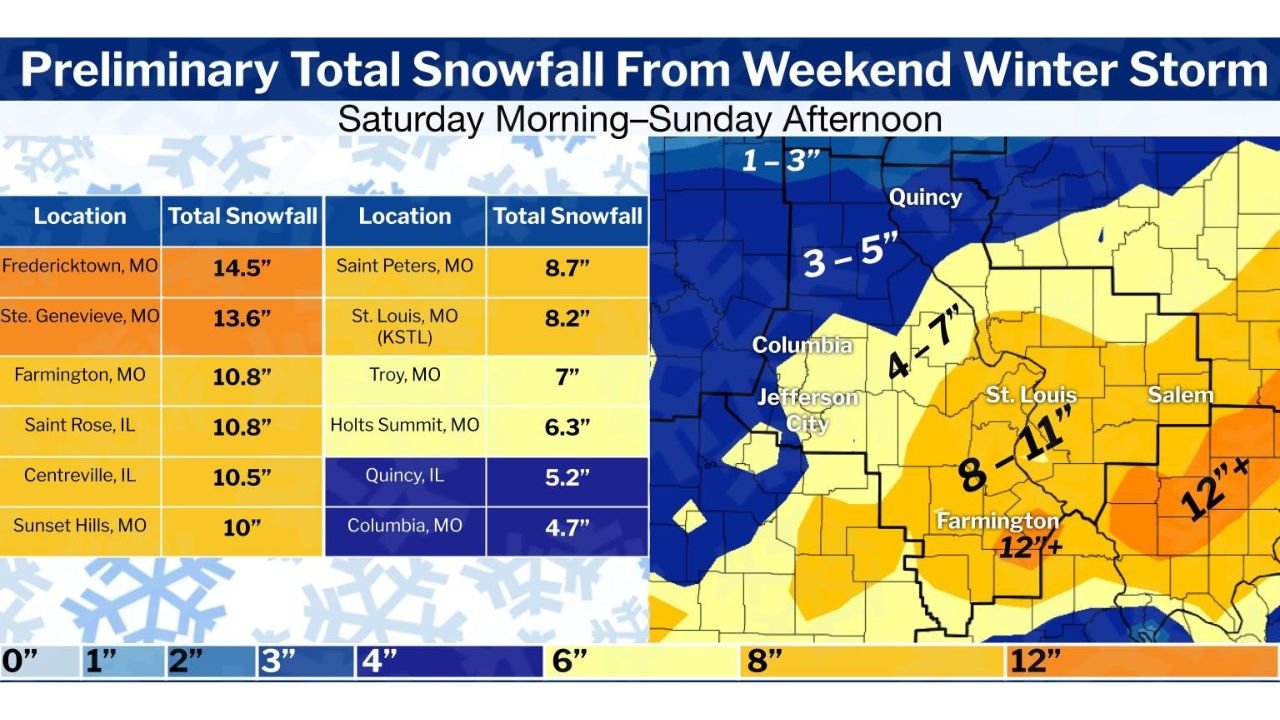
MISSOURI & ILLINOIS — A powerful weekend winter storm left behind a narrow but intense snowfall corridor across eastern Missouri and southern Illinois, where preliminary data show widespread 8 to 11 inches of snow and isolated totals exceeding 12 inches, according to compiled National Weather Service reports.
The heaviest snow fell along and just south of Interstate 44 in Missouri and Interstate 70 in Illinois, where a well-defined deformation band stalled for hours between Saturday morning and Sunday afternoon. Forecasters had flagged the risk for a focused heavy-snow axis, and post-storm totals confirm that the band materialized almost exactly where models suggested.
Where Snowfall Was Heaviest
Reports submitted to the NWS St. Louis office show several communities reaching double-digit totals, especially across southeast Missouri and adjacent parts of southern Illinois.
Highest preliminary totals include:
- Fredericktown, MO: 14.5 inches
- Ste. Genevieve, MO: 13.6 inches
- Farmington, MO: 10.8 inches
- Saint Rose, IL: 10.8 inches
- Centreville, IL: 10.5 inches
- Sunset Hills, MO: 10 inches
Additional notable totals across the region:
- Saint Peters, MO: 8.7 inches
- St. Louis (KSTL), MO: 8.2 inches
- Troy, MO: 7 inches
- Holts Summit, MO: 6.3 inches
- Quincy, IL: 5.2 inches
- Columbia, MO: 4.7 inches
North of the main snow band, totals dropped off quickly, with many locations receiving 1 to 3 inches, while areas just south of the axis still managed 4 to 7 inches.
Why the Snowfall Was So Focused
Meteorologists note that the storm featured a tight temperature gradient and strong mid-level forcing, allowing snow to accumulate rapidly in a narrow zone while nearby locations saw significantly lower amounts. This type of setup often leads to sharp cutoff lines, which were clearly visible in post-storm snowfall maps.
In southeast Missouri and southern Illinois, snowfall rates likely exceeded 1 inch per hour at times, especially Saturday evening, helping push totals past the 12-inch mark in the hardest-hit areas.
Travel and Community Impacts
The heavy snow created hazardous travel conditions, particularly along major corridors intersecting I-44 and I-70. Snow-covered roads, reduced visibility, and drifting snow persisted into Sunday, complicating cleanup efforts for road crews and emergency responders.
Many school districts and local governments across eastern Missouri and southern Illinois reported delayed reopenings as plowing and treatment continued Monday morning.
Preliminary Numbers May Still Change
Officials stress that these totals are preliminary and subject to minor revisions as additional snowfall reports are reviewed and quality-checked. Even so, the current data already confirm that this storm ranks among the more impactful regional snow events of the season for parts of Missouri and Illinois.
Residents are encouraged to continue submitting snowfall reports, which help meteorologists refine storm analyses and improve future forecasts.
Have photos, videos, or snowfall measurements from this storm? Share your experience and join the conversation at WaldronNews.com, where we continue tracking Midwest weather impacts all winter long.