
Missouri, Illinois and Indiana Face Significant Tornado Threat Thursday April 2 as Strong Low-Level Spin Targets Chicago, St. Louis, Indianapolis and Kansas City Through the Evening
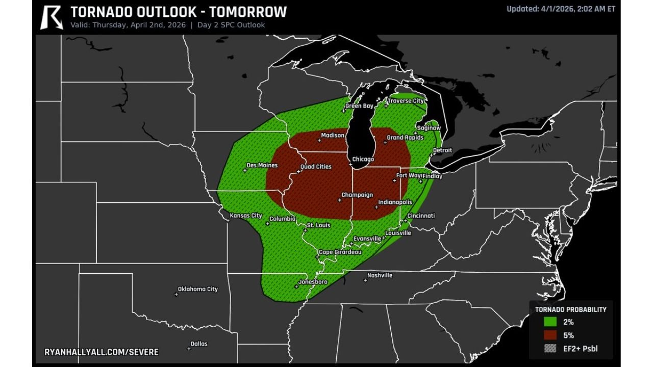
ST. LOUIS, MISSOURI — A significant tornado threat is in place for Thursday, April 2, 2026 across a large swath of the Midwest, with the SPC Day 2 Outlook identifying a corridor from northern Missouri through Illinois as the area of greatest concern. The Ryan Hall Y’All Tornado Outlook, updated April 1, 2026 at 2:02 AM ET, shows a 5% tornado probability zone — shown in dark red — covering a densely populated region that includes Chicago, St. Louis, Champaign, Indianapolis, Evansville, Kansas City, Columbia and the Quad Cities. What makes Thursday’s threat particularly concerning is that even with limited atmospheric instability, the low-level spin is strong enough to produce tornadoes embedded in fast-moving storms — meaning residents may have very little warning time if tornadoes develop.
A broader 2% tornado probability zone — shown in green — extends the threat area to include Des Moines, Madison, Green Bay, Traverse City, Saginaw, Grand Rapids, Detroit, Fort Wayne, Findlay, Cincinnati, Louisville, Cape Girardeau and Jonesboro.
Cities in the Tornado Threat Zone Thursday April 2
5% Tornado Probability Zone — highest risk:
- Illinois: Chicago, Champaign, Quad Cities, Cape Girardeau area
- Missouri: St. Louis, Kansas City, Columbia
- Indiana: Indianapolis, Evansville, Fort Wayne area
- Iowa: Quad Cities corridor
2% Tornado Probability Zone — broader risk:
- Iowa: Des Moines
- Wisconsin: Madison, Green Bay
- Michigan: Traverse City, Saginaw, Grand Rapids, Detroit
- Ohio: Findlay, Cincinnati
- Kentucky: Louisville
- Arkansas: Jonesboro
- Tennessee: Nashville on the southern fringe
Why Thursday Is More Dangerous Than a Typical Tornado Day
Thursday’s tornado threat is unusual because it does not rely on the classic ingredients that most people associate with dangerous tornado days. Normally, meteorologists look for high instability — a deeply unstable atmosphere loaded with moisture and energy — as the primary driver of significant tornadoes. Thursday April 2 is different.
Even with limited instability, the low-level wind shear and spin across the Missouri and Illinois corridor is strong enough on its own to support tornado development within fast-moving storms along the cold front. This is the kind of setup where a storm does not need to be a classic rotating supercell to produce a tornado — the spin is already present in the lower atmosphere, and storms moving through that environment can tap into it quickly and produce brief but potentially significant tornadoes with very little lead time.
The cold front tracking from northern Missouri into Illinois Thursday evening is the focal point for this threat. As the front sweeps eastward through Chicago, St. Louis and Indianapolis, the combination of the frontal boundary and the strong low-level spin creates the environment where tornado development is possible even in a relatively quick-moving storm scenario.
The EF2 or Greater Tornado Possibility
The hatched area overlaid on the dark red 5% zone indicates the possibility of EF2 or stronger tornadoes across the core of the threat corridor. An EF2 tornado has winds of 111 to 135 mph — strong enough to destroy well-constructed frame homes, uproot large trees and throw vehicles. The fact that this level of tornado potential exists even in a limited instability environment speaks to how powerful the low-level spin is across this region Thursday.
For residents of Chicago, St. Louis, Indianapolis and the surrounding metro areas, an EF2 or stronger tornado in an urban or suburban environment can cause catastrophic damage. This is not a day to dismiss the tornado threat because the sky looks partly cloudy or because storms do not look especially impressive on radar early in the day.
Fast-Moving Storms Mean Short Warning Times
One of the most important pieces of information for residents across Missouri, Illinois and Indiana to understand about Thursday is the speed of the storm system. Fast-moving storms — the kind associated with a strong cold front — produce tornadoes that also move quickly across the ground. A tornado embedded in a fast-moving squall line can travel several miles in under two minutes.
This means the standard warning time that residents may expect — 10 to 15 minutes or more ahead of a tornado — may not materialize on Thursday. The warning window could be 5 minutes or less for many communities in the path of fast-moving embedded tornadoes along the cold front.
For this reason, residents across Chicago, St. Louis, Champaign, Indianapolis and Kansas City should not wait for a warning before moving to their shelter location on Thursday evening. If a tornado watch is issued for your county — go to your shelter and stay there until the watch expires.
What to Watch Next
- Cold front arrival timing across Missouri and Illinois — the tornado threat window opens as the front pushes through each area Thursday afternoon and evening
- SPC tornado watches — watch for watch issuance across Missouri, Illinois and Indiana Thursday afternoon, likely several hours before the front arrives
- Storm motion — how fast the squall line is moving will determine how much warning time each community gets
- Chicago metro timing — when exactly the front and associated tornado threat arrives in the greater Chicago area Thursday evening
- Post-frontal conditions — how quickly the tornado threat moves east into Indiana and Ohio after clearing Illinois
Residents across Chicago, Illinois, St. Louis and Kansas City, Missouri, Indianapolis and Evansville, Indiana should treat Thursday April 2 as a serious tornado threat day, have their shelter plans finalized before Thursday afternoon and keep weather alerts active on all mobile devices through the evening hours.
WaldronNews.com will continue tracking Thursday’s tornado threat across Missouri, Illinois and Indiana and provide live updates on watches, warnings and storm reports as the cold front moves through the region.