
Missouri, Illinois, Arkansas, Tennessee and Mississippi See Tornado Surge as Early March Severe Weather Outlook Verifies with 117 Confirmed Twisters
UNITED STATES — An extended-range severe weather outlook issued in late February is now being viewed as largely on target after 117 confirmed tornadoes were recorded across parts of the Midwest and South between March 1 and March 17, 2026.
While some anticipated Southeast and Mid-Atlantic threats did not fully materialize, the broader storm corridor highlighted weeks in advance aligned closely with where tornadoes ultimately occurred.
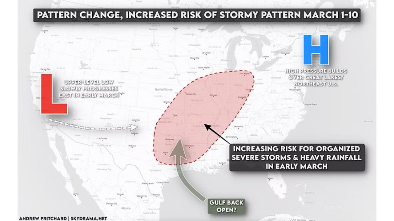
Early March Pattern Change Flagged in Advance
The late-February outlook pointed to a developing pattern shift featuring:
- An upper-level low slowly progressing east
- High pressure building over the Great Lakes and Northeast
- Increasing Gulf moisture transport northward
- A corridor of heightened severe storm potential stretching from Texas into the Mid-Mississippi Valley
The projected risk zone emphasized areas including:
- Eastern Oklahoma
- Arkansas
- Missouri
- Western Tennessee
- Western Kentucky
- Southern Illinois
That forecast window targeted early March — specifically March 1–10 — as a period of increased storm organization.
Tornado Reports Match the Corridor
Confirmed tornado data from March 1–17 shows concentrated activity across:
- Missouri, including areas near St. Louis and Springfield
- Illinois, especially near Peoria and into the Chicago region
- Arkansas and northern Mississippi
- Western Tennessee and the Memphis area
- Portions of Oklahoma and eastern Kansas
Additional tornado tracks were recorded near:
- Nashville, Tennessee
- New Orleans, Louisiana
- Parts of Alabama and Georgia
While activity in the Southeast and Mid-Atlantic was more limited than some mid-month projections suggested, the Mid-South and Mid-Mississippi Valley corridor verified strongly.
117 Tornadoes in Just Over Two Weeks
The total of 117 confirmed tornadoes during the first half of March underscores how active the pattern became.
The distribution of tracks reflects:
- Organized storm clusters
- Repeated Gulf moisture return
- Strong wind shear across the central U.S.
Multiple EF-scale ratings were observed, with a majority in the EF0–EF2 range, though stronger tornadoes were also reported within the broader outbreak episodes.
Why the Pattern Worked
The forecast discussion highlighted a key ingredient: a potentially “open Gulf” allowing warm, moist air to surge northward.
That moisture return combined with:
- Strong upper-level dynamics
- Surface boundaries
- Repeated storm system progression
created favorable conditions for organized severe weather across the central United States.
High pressure over the Great Lakes also helped channel instability and shear into the highlighted zone.
What Didn’t Happen
Some mid-month Southeast and Mid-Atlantic expectations were less active than initially feared.
That is common in extended-range forecasting, where subtle shifts in storm track can dramatically alter impact zones.
Still, the primary early-March corridor across Missouri, Illinois, Arkansas, Tennessee and Mississippi verified with notable accuracy.
Looking Ahead to Late March and April
With more than 100 tornadoes already confirmed in early March, the central and southern U.S. remain in a climatologically favorable window for continued severe weather.
As spring advances:
- Gulf moisture availability typically increases
- Jet stream dynamics remain active
- Tornado frequency often rises
Communities across the Mid-South and Midwest should remain prepared as the peak spring season approaches.
Stay with WaldronNews.com for continued updates as the 2026 severe weather season unfolds across the United States.