
Missouri Weather Chaos Unfolds as Tornado Warnings Near St. Louis Collide with Snow Squalls Around Kansas City and Iowa Border
MISSOURI — An extraordinary weather setup is unfolding across Missouri as tornado warnings, severe thunderstorms and snow squalls are occurring at the same time across different parts of the state, creating one of the most chaotic weather patterns seen this season.
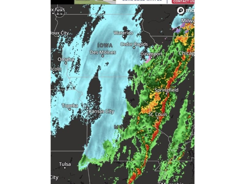
Radar imagery shows a powerful line of severe thunderstorms stretching across eastern Missouri near St. Louis and Springfield, while just a few hundred miles to the northwest, heavy snow is falling across northern Missouri, Iowa and areas near Kansas City.
Meteorologists say the unusual setup is the result of a powerful spring storm system colliding with cold air still lingering across the Midwest.
Tornado Warnings and Severe Storms Near St. Louis
The most dangerous conditions are occurring across eastern Missouri, where a narrow but intense line of thunderstorms is moving through the region.
Cities including:
- St. Louis
- Springfield
- Columbia
- Jefferson City
are seeing strong storms capable of producing damaging winds, heavy rain and possible tornadoes.
The line of storms appears to be part of a fast-moving squall line, which can quickly produce rotating storms and brief tornadoes as it moves across the state. Meteorologists say tornado warnings have already been issued in parts of the region as storms continue pushing eastward.
Snow Squalls Blasting Northern Missouri and Iowa
At the same time severe storms are raging in the east, a completely different weather scenario is unfolding farther north and west.
Radar shows widespread snowfall stretching across northern Missouri, Iowa and areas surrounding Kansas City, where strong winds are producing bursts of heavy snow.
Cities in this region include:
- Kansas City
- Des Moines
- Cedar Rapids
- Waterloo
These snow squalls can cause rapidly changing visibility and dangerous driving conditions, sometimes reducing visibility to near zero within minutes.
A Rare Collision of Winter and Severe Weather
Meteorologists say the reason for this bizarre weather pattern is the dramatic clash between warm, unstable air surging north from the Gulf of Mexico and colder air plunging south from the northern Plains.
This collision creates a powerful storm system capable of producing multiple types of extreme weather simultaneously, including:
- Tornadoes
- Severe thunderstorms
- Snow squalls
- Heavy rain
- Strong winds
Such dramatic weather contrasts are occasionally seen during the transition from winter to spring, but forecasters say it is unusual to see so many warning types occurring across one state at the same time.
Storm System Continuing to Move East
The severe thunderstorm line is expected to continue moving east through Illinois and the Mississippi Valley, while snow and colder air remain across parts of Iowa and the northern Plains.
As the storm pushes eastward overnight, additional severe weather could develop across areas farther down the storm track. Meanwhile, snow and strong winds may continue across northern sections of the region.
Residents Urged to Monitor Rapidly Changing Conditions
Because conditions vary dramatically across Missouri, meteorologists are urging residents to stay alert to changing weather conditions.
Officials recommend:
- Monitoring local weather alerts
- Avoiding travel during intense storms or snow squalls
- Preparing for rapidly changing weather conditions
Weather experts say this storm system demonstrates just how unpredictable early spring weather can be across the Midwest. Stay with WaldronNews for continuing updates as this powerful storm system moves across Missouri and the central United States.