
Montana, North Dakota, Minnesota and Michigan Brace for Dangerous Windstorm as 80 MPH Gusts Sweep the Upper Midwest and Great Lakes
UNITED STATES — A powerful windstorm is expected to sweep across the Upper Midwest and Great Lakes from Thursday night into Friday, bringing the potential for damaging wind gusts exceeding 70 to 80 mph across parts of Montana and North Dakota, with strong winds spreading eastward into Minnesota, Wisconsin, Illinois, and Michigan.
Meteorologists say the wind event will develop behind a powerful low-pressure system moving across the northern United States, the same storm system responsible for bringing snow and possible blizzard conditions to parts of North Dakota and Michigan’s Upper Peninsula.
Forecast wind guidance suggests millions of people across the northern U.S. could experience strong and potentially damaging winds as the system intensifies.
Extreme Winds Possible Across Montana and Western North Dakota
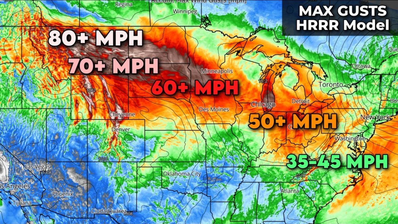
The strongest winds are expected across the northern Plains and Rocky Mountain foothills, where the pressure gradient behind the storm will be strongest.
Forecast models show gust potential of:
- 80+ mph in parts of Montana
- 70+ mph across western North Dakota
These wind speeds are capable of producing widespread damage, including downed trees, power lines, and dangerous travel conditions.
The mountainous terrain and open plains of Montana can often amplify strong wind events, especially when powerful storms pass through the region.
Western Minnesota Could See 60–70 MPH Gusts
As the system moves east, very strong winds are expected to spread into western Minnesota, where gusts may reach 60 mph or higher, with some locations possibly approaching 70 mph.
Cities that may experience the strongest winds in this region include:
- Fargo
- Moorhead
- Alexandria
- Western Minneapolis metro communities
Strong crosswinds could create hazardous conditions on highways, particularly for semi-trucks, buses, and other high-profile vehicles.
Widespread 50–60 MPH Winds Across the Midwest
Farther east, a large portion of the Upper Midwest and Great Lakes region could experience widespread wind gusts between 50 and 60 mph.
This includes major metropolitan areas such as:
- Minneapolis, Minnesota
- Des Moines, Iowa
- Chicago, Illinois
- Milwaukee, Wisconsin
- Detroit, Michigan
Although slightly lower than the extreme gusts expected in the Plains, winds at this level can still cause scattered power outages and tree damage, especially if soils are wet or trees are weakened from previous storms.
Blizzard Conditions Possible in Northern Areas
The windstorm is tied to a powerful winter system that may also produce snow and blizzard conditions on the northern side of the storm.
The areas most likely to experience winter storm conditions include:
- North Dakota
- Northern Minnesota
- Michigan’s Upper Peninsula
Strong winds combined with falling snow could lead to reduced visibility and dangerous travel conditions, particularly in rural areas and along open highways.
Blizzard conditions occur when heavy snow combines with winds above 35 mph, and the forecast wind speeds could easily exceed that threshold.
Strong Winds Expected to Reach the Great Lakes
As the system continues moving eastward, strong winds will likely spread into the Great Lakes region, impacting states such as Wisconsin, Illinois, Michigan, and Indiana.
Wind gusts around 50 mph could reach cities including:
- Chicago
- Detroit
- Cleveland
While winds will gradually weaken farther east, gusty conditions may continue across parts of the Ohio Valley and Northeast as the storm progresses.
Power Outages and Travel Hazards Possible
Meteorologists warn that a wind event of this magnitude could lead to scattered power outages across multiple states, particularly where the strongest gusts occur.
Utility crews across the Midwest and Plains may be placed on alert as the storm approaches.
Drivers of large trucks and high-profile vehicles are also being advised to monitor weather conditions carefully, as strong crosswinds can make travel extremely dangerous.
Wind Event Expected to Peak Thursday Night Through Friday
Forecast guidance indicates that the strongest winds will likely develop Thursday night and continue through Friday as the powerful storm system moves across the northern United States.
Because wind forecasts can shift as new data becomes available, meteorologists will continue refining the exact locations of the strongest gusts in the coming days.
However, the current outlook suggests that a large portion of the Upper Midwest and Great Lakes could experience one of the strongest wind events of the season.
Stay with WaldronNews for continued updates as meteorologists track this powerful windstorm across Montana, North Dakota, Minnesota, and the broader Midwest.