
Multi Day Storm Warning Issued for Texas, Oklahoma, Kansas, Missouri, Iowa, Illinois and Mississippi Valley as Severe Weather Surge Begins This Weekend
UNITED STATES — A widespread and potentially dangerous multi-day severe weather outbreak is now expected to unfold from Saturday through Wednesday, targeting a large portion of the Plains, Midwest, and Mississippi Valley.
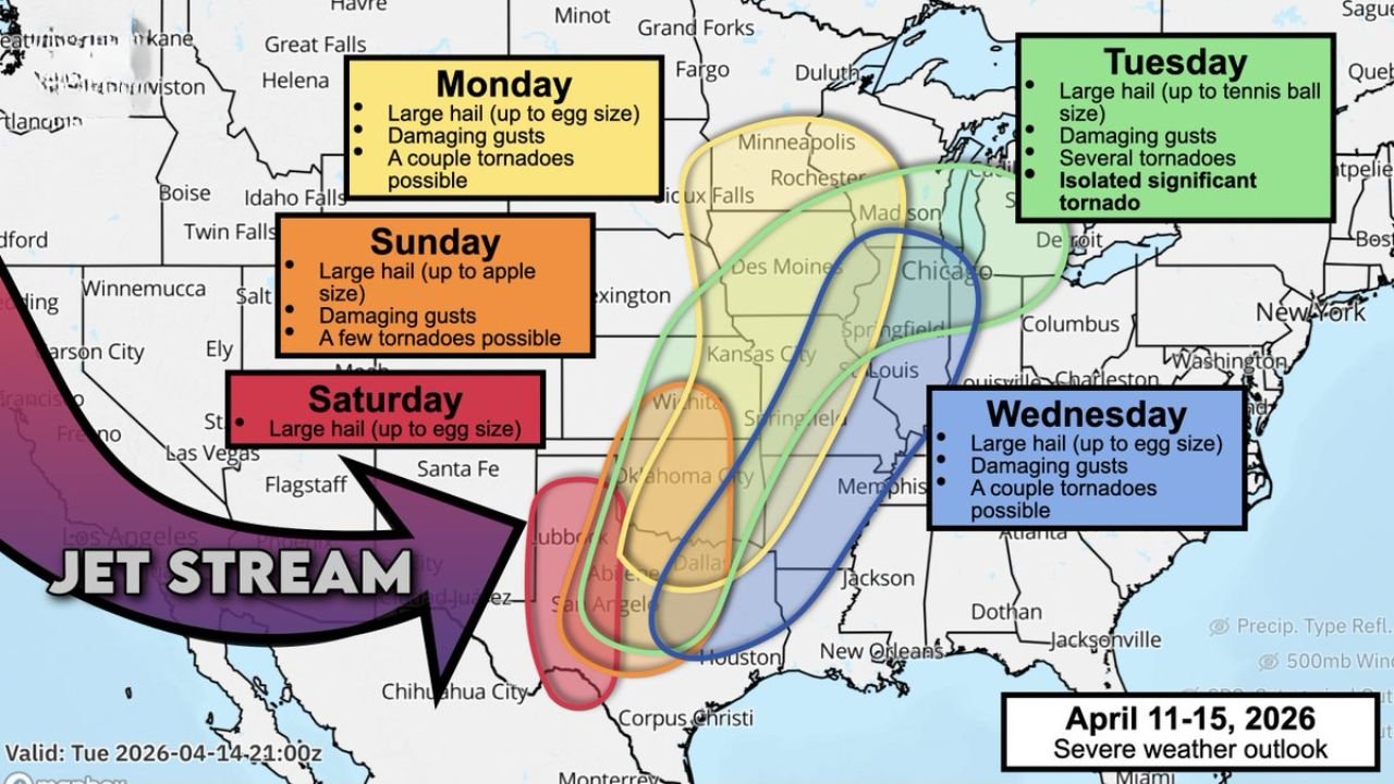
This evolving setup shows multiple rounds of severe storms, including risks for large hail, damaging winds, and tornadoes, with the threat shifting north and east each day.
Saturday: West Texas Ignites the Pattern
The outbreak begins Saturday across:
- West Texas, including areas near Lubbock and Abilene
A sharpening dryline and incoming jet stream disturbance will trigger:
- Supercells capable of large hail (up to egg size)
- Storms transitioning into a wind-driven line overnight
This marks the starting point of a broader, multi-day severe pattern.
Sunday: Texas to Oklahoma Sees Intensifying Threat
By Sunday, conditions reset and become more unstable across:
- Texas and Oklahoma
Storms are expected to redevelop with:
- Large hail up to apple size
- Damaging winds
- A few tornadoes possible
The environment becomes more supportive of organized severe storms, increasing overall risk.
Monday: Kansas and Missouri Move Into Focus
On Monday, the severe weather zone expands north into:
- Kansas, Missouri, and parts of Iowa
Forecast signals suggest:
- Large hail up to egg size
- Damaging wind gusts
- A few tornadoes possible, especially in Kansas
Some storms during this phase may become intense supercells, particularly in the central Plains.
Tuesday: Midwest Faces Peak Severe Risk
Tuesday stands out as a high-impact day, with the threat shifting into:
- Missouri, Iowa, Illinois, and Wisconsin
This phase could bring:
- Large hail up to tennis ball size
- Widespread damaging winds
- Multiple tornadoes, including the possibility of strong or significant tornadoes
The combination of strong jet stream energy and abundant moisture suggests this could be the most dangerous day of the outbreak.
Wednesday: Storms Push Into Mississippi Valley and Tennessee
By Wednesday, the system continues eastward into:
- Arkansas, Mississippi, Tennessee, and surrounding areas
Expected threats include:
- Large hail
- Damaging winds
- A couple of tornadoes possible
While slightly less intense than Tuesday, severe storms remain a concern.
Why This Setup Is Concerning
This pattern is being driven by:
- A persistent jet stream dip across the western U.S.
- Repeated storm system development along the Plains
- A steady supply of warm, moist Gulf air feeding northward
This combination creates a classic severe weather corridor, often associated with prolonged outbreaks.
Areas Most at Risk Overall
Across the full event window, the highest concern stretches from:
- Texas and Oklahoma
- Through Kansas, Missouri, and Iowa
- Into the Midwest and Mississippi Valley
This corridor will see repeated rounds of storms, increasing the risk of cumulative impacts.
Bottom Line
A multi-day severe weather outbreak is now expected from Saturday through Wednesday across a large part of the central United States.
With large hail, damaging winds, and tornadoes possible on multiple days, this is a setup that requires close attention.
Residents across Texas, Oklahoma, Kansas, Missouri, Iowa, Illinois, and surrounding states should begin preparing now and stay alert for forecast updates as this dangerous pattern unfolds.