
Multi-State Winter Storm Threat Targets Texas, Oklahoma, Arkansas, Tennessee, Georgia, the Carolinas, and Virginia This Weekend
UNITED STATES — A large and potentially high-impact winter storm is taking shape for Saturday into Sunday, with confidence increasing that snow, sleet, and freezing rain will stretch across a massive portion of the country — impacting millions across the South, Midwest, and Southeast.
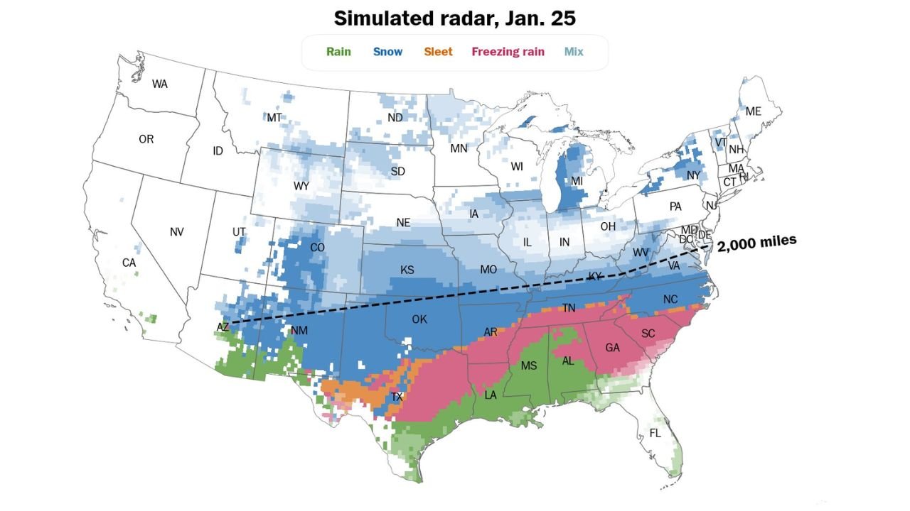
Forecast guidance shows a 2,000-mile-long winter weather corridor, with around 160 million people expected to experience some form of wintry precipitation at the same time as the system moves east.
Winter Weather Probabilities Increase From the Southern Plains Into the Carolinas
Probability maps indicate a high likelihood of impactful winter weather, especially from the Southern Plains through the Tennessee Valley and into the Carolinas.
- 70–90% chance:
Northern North Carolina, southern Virginia, and portions of eastern Tennessee - 50–70% chance:
Central North Carolina, northern South Carolina, and parts of Tennessee - 10–30% chance:
Central South Carolina and southern Georgia - 1–10% chance:
Coastal Georgia and parts of coastal South Carolina
These probabilities reflect the chance of exceeding 0.25 inches of ice or 2.5 inches of snow or sleet, which would be enough to cause travel disruptions, power issues, and dangerous road conditions.
Snow, Ice, and Freezing Rain All Possible Depending on Location
Forecast confidence is high that multiple precipitation types will be involved, but exact placement remains uncertain this far out. Cold surface temperatures mean whatever falls is likely to stick, increasing impacts.
Early projections suggest:
- Snow likely across Texas Panhandle, Oklahoma, Kansas, Missouri, Tennessee, Kentucky, and North Carolina
- Freezing rain and sleet favored across Texas, Arkansas, Louisiana, Mississippi, Alabama, Georgia, and South Carolina
- Rain farther south into parts of Mississippi, Alabama, and Florida
City-by-City Early Sunday Precipitation Snapshot
Here’s how precipitation types could break down in select cities early Sunday:
- Sedona, Arizona – Snow
- Albuquerque, New Mexico – Snow
- Lubbock, Texas – Snow
- Dallas, Texas – Freezing rain
- Austin, Texas – Freezing rain
- Oklahoma City, Oklahoma – Snow
- Tulsa, Oklahoma – Snow
- Wichita, Kansas – Snow
- Kansas City, Missouri – Snow
- St. Louis, Missouri – Snow
- Little Rock, Arkansas – Sleet
- Shreveport, Louisiana – Freezing rain
- Memphis, Tennessee – Freezing rain
- Nashville, Tennessee – Snow
- Louisville, Kentucky – Snow
- Atlanta, Georgia – Freezing rain
- Augusta, Georgia – Freezing rain
- Columbia, South Carolina – Freezing rain
- Charleston, South Carolina – Freezing rain
- Myrtle Beach, South Carolina – Freezing rain
- Charlotte, North Carolina – Snow
- Raleigh, North Carolina – Snow
- Virginia Beach, Virginia – Snow
Why This Storm Has High Impact Potential
Meteorologists are stressing that this is not just a snow event. The ice threat may be more dangerous, especially in the South where freezing rain can quickly lead to:
- Widespread power outages
- Tree damage
- Hazardous road conditions
- Prolonged travel disruptions
With very cold surface temperatures, even light ice accumulation could cause major problems, particularly overnight.
What Happens Next
As the storm moves closer, forecast confidence will increase, but changes to storm track and precipitation type are still likely. Residents across the affected states should begin preparing now and monitor updates closely through the week.
Stay alert and keep checking back with Waldron News for the latest winter storm updates, probability shifts, and state-by-state impact details as this major weather system develops.