
National Weather Outlook Shows Dramatic Temperature Divide as Arctic Air Targets Eastern U.S. While Western States Brace for Unusual Warmth
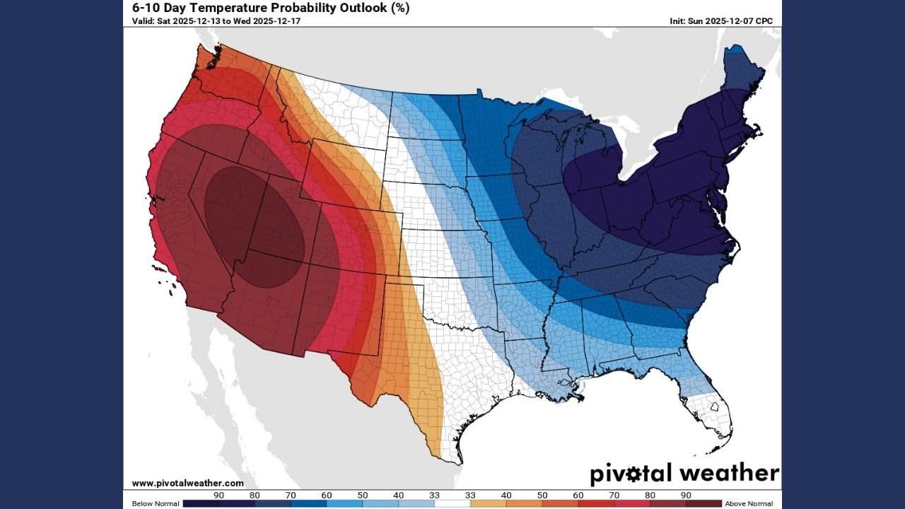
UNITED STATES — A newly released 6–10 Day Temperature Probability Outlook from the Climate Prediction Center shows a striking and intensifying temperature split across the country, with bitterly cold Arctic air expanding across the Midwest, Great Lakes, and East Coast, while the Western U.S. faces unusually warm conditions heading into mid-December.
The updated maps, valid from December 13 to December 17, reveal that the blue-shaded cold zone has widened and deepened, signaling a pattern forecasters say may become a recurring theme throughout Winter 2025.
Arctic Blast Expands Across Half the Nation
The latest outlook shows a significant push of below-normal temperatures stretching from the Central Plains through the Ohio Valley, and deep into the Northeast and Mid-Atlantic.
Meteorologists note that the deep purples and darker blues indicate high confidence in colder-than-normal temperatures.
According to the posted analysis:
“The only thing that has changed lately is the blue area has gotten bigger and bluer. Likely a recurring theme this winter…”
This suggests continued reinforcement of Arctic air, with storm systems likely to develop along the thermal boundary separating warm and cold regions.
West Coast Locked Into a Warm Pattern
While the eastern half of the country prepares for winter-like chill, the West Coast and Southwest are forecast to remain under a strong above-normal temperature pattern.
The deepest red shading — spanning California, Nevada, Utah, and Arizona — indicates very high odds of unseasonable warmth.
Forecasters say this warm West / cold East pattern aligns with long-range atmospheric trends observed over the last several weeks.
Why the Temperature Split Matters
This sharp temperature contrast can influence:
- Storm development across the central U.S.
- Snowfall potential for the Great Lakes and Northeast
- Energy demand, especially in colder regions
- Travel conditions heading toward the holiday period
The expanding cold belt also raises the likelihood of lake-effect snow events, particularly around the Great Lakes, as Arctic air sweeps over warmer waters.
Trending Pattern for Winter 2025
Meteorologists widely note that once a winter pattern becomes established — like the current warm West / cold East split — it can persist for weeks.
This early-season data suggests:
- Persistent cold outbreaks for states east of the Mississippi
- Storm track shifts toward the Midwest and East
- Warmer, drier conditions dominating much of the West
With the core of the cold intensifying, residents from Minnesota to Georgia may see temperatures fall well below seasonal norms as mid-December approaches.
What Happens Next?
Forecasters will continue monitoring:
- The strength of the Arctic air mass
- Any storm systems forming along the temperature boundary
- Potential impacts on holiday travel, agriculture, and utilities
As of now, long-range analysts agree: the cold pattern gripping the East appears locked in, and could be a defining feature of Winter 2025.
How will this temperature divide impact your region? Stay informed with the latest national and local weather updates only at WaldronNews.com.